Wilcox County, Georgia facts for kids
Quick facts for kids
Wilcox County
|
|
|---|---|

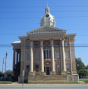
Wilcox County Courthouse in Abbeville
|
|

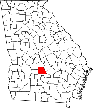
Location within the U.S. state of Georgia
|
|
 Georgia's location within the U.S. |
|
| Country | |
| State | |
| Founded | December 22, 1857 |
| Named for | Mark Wilcox |
| Seat | Abbeville |
| Largest city | Abbeville |
| Area | |
| • Total | 382 sq mi (990 km2) |
| • Land | 378 sq mi (980 km2) |
| • Water | 4.4 sq mi (11 km2) 1.2%% |
| Population
(2020)
|
|
| • Total | 8,766 |
| • Density | 23/sq mi (9/km2) |
| Time zone | UTC−5 (Eastern) |
| • Summer (DST) | UTC−4 (EDT) |
| Congressional district | 8th |
Wilcox County is a county located in the south-central part of the U.S. state of Georgia. In 2020, about 8,766 people lived there. The main town and county seat is Abbeville.
Contents
History of Wilcox County
Wilcox County was created on December 22, 1857. It was made from parts of three other counties: Irwin, Pulaski, and Dooly. The county is named after General Mark Wilcox. He was a lawmaker in Georgia and helped start the Georgia Supreme Court, which is the highest court in the state.
The first building for the county government was built in 1858. The building used today was built in 1903.
Geography and Rivers
Wilcox County covers a total area of about 382 square miles. Most of this area, about 378 square miles, is land. The remaining 4.4 square miles, or 1.2%, is water.
The northern and eastern parts of Wilcox County are in the Lower Ocmulgee River area. This river flows into the larger Altamaha River basin. The southwestern part of the county is in the Alapaha River area. This river flows into the Suwannee River basin.
Neighboring Counties
Wilcox County shares borders with several other counties:
- Pulaski County - to the north
- Dodge County - to the east
- Telfair County - to the east
- Ben Hill County - to the south
- Turner County - to the southwest
- Crisp County - to the west
- Dooly County - to the northwest
Main Roads in Wilcox County
Several important highways pass through Wilcox County:
Towns and Cities
Wilcox County has several communities:
Cities
Town
Census-designated place
Population Information
| Historical population | |||
|---|---|---|---|
| Census | Pop. | %± | |
| 1860 | 2,115 | — | |
| 1870 | 2,439 | 15.3% | |
| 1880 | 3,109 | 27.5% | |
| 1890 | 7,980 | 156.7% | |
| 1900 | 11,097 | 39.1% | |
| 1910 | 13,486 | 21.5% | |
| 1920 | 15,511 | 15.0% | |
| 1930 | 13,439 | −13.4% | |
| 1940 | 12,755 | −5.1% | |
| 1950 | 10,167 | −20.3% | |
| 1960 | 7,905 | −22.2% | |
| 1970 | 6,998 | −11.5% | |
| 1980 | 7,682 | 9.8% | |
| 1990 | 7,008 | −8.8% | |
| 2000 | 8,577 | 22.4% | |
| 2010 | 9,255 | 7.9% | |
| 2020 | 8,766 | −5.3% | |
| 2023 (est.) | 8,779 | −5.1% | |
| U.S. Decennial Census 1790-1880 1890-1910 1920-1930 1930-1940 1940-1950 1960-1980 1980-2000 2010 2020 |
|||
As of the 2020 United States census, there were 8,766 people living in Wilcox County. There were 2,575 households and 1,807 families. Most residents identified as White (59.15%) or Black/African American (35.32%). About 3.10% of the population was Hispanic or Latino.
Education
The schools in Wilcox County are managed by the Wilcox County Schools. The main office for the district is in Abbeville. The schools, including Wilcox County High School, are located in Rochelle.
Local Events
The Ocmulgee Wild Hog Festival is a fun event held every year in Abbeville. It takes place on the Saturday before Mother's Day.
See also
 In Spanish: Condado de Wilcox (Georgia) para niños
 | Sharif Bey |
 | Hale Woodruff |
 | Richmond Barthé |
 | Purvis Young |

