Telfair County, Georgia facts for kids
Quick facts for kids
Telfair County
|
|
|---|---|

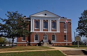
Telfair County Courthouse in McRae-Helena
|
|

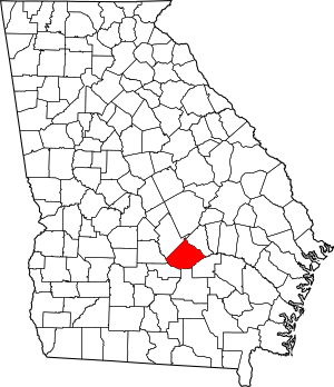
Location within the U.S. state of Georgia
|
|
 Georgia's location within the U.S. |
|
| Country | |
| State | |
| Founded | December 10, 1807 |
| Named for | Edward Telfair |
| Seat | McRae-Helena |
| Largest city | McRae-Helena |
| Area | |
| • Total | 444 sq mi (1,150 km2) |
| • Land | 437 sq mi (1,130 km2) |
| • Water | 6.7 sq mi (17 km2) 1.5%% |
| Population
(2020)
|
|
| • Total | 12,477 |
| • Density | 29/sq mi (11/km2) |
| Time zone | UTC−5 (Eastern) |
| • Summer (DST) | UTC−4 (EDT) |
| Congressional district | 8th |
Telfair County is a county located in the central part of Georgia, a state in the United States. In 2020, about 12,477 people lived here. The biggest city and the place where the county government is located is McRae-Helena.
In 2009, scientists from the Fernbank Museum of Natural History found old items near the Ocmulgee River. They believe these items came from the Hernando de Soto Expedition in 1541. This was the first time such items were found between Tallahassee, Florida and western North Carolina. De Soto's journey was well-recorded, but finding things he left behind has been hard. This site was once a village of the Creek people from the early 1400s to the 1500s. It was located further southeast than people thought de Soto's group traveled in Georgia.
Contents
Exploring Telfair County's Past
Archaeologists from Atlanta's Fernbank Museum of Natural History started digging in a large area near McRae-Helena in 2005. This area is about a mile from the Ocmulgee River. In 2009, they announced they had found proof of a Spanish settlement from the early 1500s.
At first, the archaeologists thought the items might be from a settlement started by Spanish leader Lucas Vázquez de Ayllón in 1526. Hundreds of settlers came with him, but they faced very tough conditions. Fewer than 200 people survived to return home.
Discoveries from the De Soto Expedition
Later research suggested that the site was actually visited in 1541 by the de Soto Expedition. Researchers have found special glass beads made in Venice, Italy. The Spanish brought these beads to trade with Native Americans. They also found pieces of pottery and iron weapons.
Some of the beads have a unique chevron pattern. These types of beads are a special sign of the de Soto expedition. This is because they were only made for a short time. The digs also uncovered six metal objects. These included three iron tools and a silver pendant.
This discovery showed that the de Soto expedition traveled further west than experts had thought. Before this, evidence of his trip was only found in Tallahassee, Florida, and western North Carolina. This was the first time items from his journey were found in between these two places.
What we have now is the best-documented collection of Spanish artifacts in Georgia; many are unique, and they are the only examples of certain artifacts ever found outside Florida.
Scientists believe this site was a Native American village. People lived there from the late 1400s to the early 1500s. At that time, they did not have glass or metal goods of their own. Dennis Blanton shared his findings in November 2009 at a meeting in Mobile, Alabama.
Founding of Telfair County
The Creek people lived in much of this area of Georgia for thousands of years. European Americans officially created Telfair County on December 10, 1807. The county grew a lot after the Indian Removal in the 1830s. During this time, the Creek Confederacy was forced to move from their lands. They were moved to Indian Territory west of the Mississippi River, which is now Oklahoma.
The county is named after Edward Telfair. He was the sixteenth governor of Georgia and a member of the Continental Congress. Many of the first European-American settlers were Scottish immigrants. Others were Scots-Irish people who moved south from Pennsylvania and Virginia.
World Record Largemouth Bass
Telfair County is also famous for a world record! The biggest largemouth bass ever caught is a tie between two fish. One was caught by Manabu Kurita in Japan in 2009. It weighed 10.12 kilograms (22 pounds, 5 ounces). The other was caught by George W. Perry on June 2, 1932. This fish was caught in Montgomery Lake in Georgia and weighed 10.09 kilograms (22 pounds, 4 ounces). Montgomery Lake is actually a bend in the Ocmulgee River near Lumber City, Georgia and Jacksonville, Georgia.
Geography of Telfair County
Telfair County covers about 444 square miles. Most of this area, about 437 square miles, is land. The remaining 6.7 square miles (1.5%) is water. The county has at least 50 artesian wells, which are natural springs where water flows up from the ground.
The southern two-thirds of Telfair County are in the Lower Ocmulgee River area. This river flows into the Altamaha River. The northern part of the county is in the Little Ocmulgee River area, which also flows into the Altamaha River.
Main Roads in Telfair County
Neighboring Counties
Telfair County shares its borders with these other counties:
- Wheeler County (to the northeast)
- Jeff Davis County (to the southeast)
- Coffee County (to the south)
- Ben Hill County (to the southwest)
- Wilcox County (to the west)
- Dodge County (to the northwest)
- Laurens County (to the north)
Communities in Telfair County
Cities
- McRae-Helena (the county seat)
- Jacksonville
- Lumber City
- Milan
- Scotland
Other Communities
- China Hill
- Towns
- Workmore
People of Telfair County
| Historical population | |||
|---|---|---|---|
| Census | Pop. | %± | |
| 1810 | 744 | — | |
| 1820 | 2,104 | 182.8% | |
| 1830 | 2,136 | 1.5% | |
| 1840 | 2,763 | 29.4% | |
| 1850 | 3,026 | 9.5% | |
| 1860 | 2,713 | −10.3% | |
| 1870 | 3,245 | 19.6% | |
| 1880 | 4,828 | 48.8% | |
| 1890 | 5,477 | 13.4% | |
| 1900 | 10,083 | 84.1% | |
| 1910 | 13,288 | 31.8% | |
| 1920 | 15,291 | 15.1% | |
| 1930 | 14,997 | −1.9% | |
| 1940 | 15,145 | 1.0% | |
| 1950 | 13,221 | −12.7% | |
| 1960 | 11,715 | −11.4% | |
| 1970 | 11,381 | −2.9% | |
| 1980 | 11,445 | 0.6% | |
| 1990 | 11,000 | −3.9% | |
| 2000 | 11,794 | 7.2% | |
| 2010 | 16,500 | 39.9% | |
| 2020 | 12,477 | −24.4% | |
| 2023 (est.) | 10,920 | −33.8% | |
| U.S. Decennial Census 1790-1880 1890-1910 1920-1930 1930-1940 1940-1950 1960-1980 1980-2000 2010 |
|||
In 2020, there were 12,477 people living in Telfair County. There were 4,668 households and 3,259 families.
| Group | Number | Percentage |
|---|---|---|
| White (not Hispanic) | 5,970 | 47.85% |
| Black or African American (not Hispanic) | 4,326 | 34.67% |
| Native American | 28 | 0.22% |
| Asian | 30 | 0.24% |
| Other/mixed | 195 | 1.56% |
| Hispanic or Latino | 1,928 | 15.45% |
Notable People from Telfair County
- Eugene Talmadge
- Herman Talmadge
- James E. Livingston
- Marion B. Folsom
- Kim Batten
- James McRae (United States Army officer)
See also
 In Spanish: Condado de Telfair para niños
 | Dorothy Vaughan |
 | Charles Henry Turner |
 | Hildrus Poindexter |
 | Henry Cecil McBay |


