McRae–Helena, Georgia facts for kids
Quick facts for kids
McRae–Helena, Georgia
|
|
|---|---|

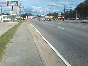
Downtown McRae–Helena, Georgia
|
|
| Nickname(s):
The Purple Heart City
|
|
| Motto(s):
The Crossroads City
|
|
| Country | United States |
| State | Georgia |
| County | Telfair, Wheeler |
| Area | |
| • Total | 6.53 sq mi (16.92 km2) |
| • Land | 6.44 sq mi (16.67 km2) |
| • Water | 0.10 sq mi (0.25 km2) |
| Population
(2020)
|
|
| • Total | 6,253 |
| • Density | 971.57/sq mi (375.15/km2) |
| ZIP code |
31055
|
| Area code(s) | 229, 912 |
| FIPS code | 13-49100 |
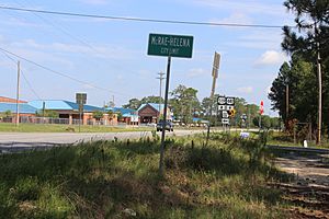
McRae–Helena is a city in the U.S. state of Georgia. It was formed on January 1, 2015. This happened when the two cities of McRae and Helena joined together. McRae–Helena is the main city, also known as the county seat, of Telfair County.
It is the largest city in Telfair County. In 2020, its population was 6,253 people. This number includes people living in local facilities.
Contents
History of McRae–Helena
On January 1, 2015, the cities of McRae and Helena officially merged. This merger created the new city of McRae–Helena. The idea for the merger came about when Helena faced problems with its water system. It made sense for nearby McRae to help with Helena's water services.
This change would have greatly reduced Helena's income. It would have left Helena with only two city services. To solve this, the cities decided to unite. Representative Jimmy Pruett helped make this happen. He sponsored House Bill 967. Governor Nathan Deal signed this bill into law on April 10, 2014.
Geography of McRae–Helena
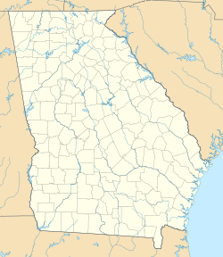
McRae–Helena is located in the northern part of Telfair County. Its coordinates are 32°3′52″N 82°53′54″W / 32.06444°N 82.89833°W.
The city covers about 6.44 square miles of land. Its total area, including water, is about 6.53 square miles. The Little Ocmulgee River flows just northeast of the city. Sugar Creek runs along the southwest edge of the city.
Getting Around McRae–Helena
Several major roads pass through McRae–Helena. U.S. Route 23 and U.S. Route 341/State Route 27 go through the city. They use Martin Luther King Jr. Boulevard and Oak Street. These roads lead northwest to Eastman and southeast to Hazlehurst.
Other important roads include U.S. Route 280, U.S. Route 319, U.S. Route 441, State Route 30, and State Route 31. They all travel along Third Avenue. These roads connect McRae–Helena to cities like Vidalia, Cordele, Jacksonville, and Dublin.
Railroad lines also run through the city. The Norfolk Southern Railway passes through both former cities. The Heart of Georgia Railroad also has a line that went through Helena. These lines meet in what was once Helena.
Places to Visit in McRae–Helena
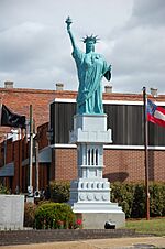
In downtown McRae–Helena, you can find Liberty Square. This square features a replica of the Statue of Liberty. It is one-twelfth the size of the original statue. Liberty Square also has a copy of the Liberty Bell. There is a marble memorial there too. It honors Telfair County residents who served in the military.
On the edge of McRae–Helena is the Talmadge Home. This old house was home to two former Georgia governors. They were Eugene Talmadge and Herman Eugene Talmadge. McRae–Helena was also the birthplace of Marion B. Folsom (1893–1976). He was a leader at the Eastman Kodak Company. He also served in the U.S. government under President Dwight D. Eisenhower.
Education in McRae–Helena
Telfair County School District
The Telfair County School District serves students from pre-school to twelfth grade. It includes one elementary school, one middle school, and one high school. The district has 112 full-time teachers. Over 1,648 students attend these schools.
- Telfair County Elementary School
- Telfair County Middle School
- Telfair County High School
- Telfair County Pre-K
Colleges and Universities
- Oconee Fall Line Technical College has a campus in McRae–Helena.
Population of McRae–Helena
| Historical population | |||
|---|---|---|---|
| Census | Pop. | %± | |
| 2020 | 6,253 | — | |
| 2023 (est.) | 4,759 | ||
| U.S. Decennial Census | |||
As of 2022, there were about 6,338 people living in McRae–Helena. There were also about 1,215 households. The city had about 985 people per square mile.
The people living in the city came from various backgrounds. About 41.6% were White. About 34.0% were Black or African American. About 10.5% were from other races. About 13.5% were from two or more races. People of Hispanic or Latino background made up 24.6% of the population.
The average household had about 3.49 people. The average family had about 4.21 people. About 24.5% of the population was under 18 years old. About 14.2% were 65 or older. The average age in the city was 36.4 years.
Economy of McRae–Helena
McRae–Helena has several important employers. These businesses and organizations provide many jobs for the community.
- Husqvarna (a company known for outdoor power products)
- City of McRae–Helena (local government jobs)
- Coca-Cola Bottling Plant (produces beverages)
- Golden Peanut Company (processes peanuts)
- Little Ocmulgee State Park (tourism and recreation)
- Cook Petro
- Griffins Warehouse–McRae, LLC
 | Delilah Pierce |
 | Gordon Parks |
 | Augusta Savage |
 | Charles Ethan Porter |


