McRae, Georgia facts for kids
Quick facts for kids
McRae, Georgia
|
|
|---|---|

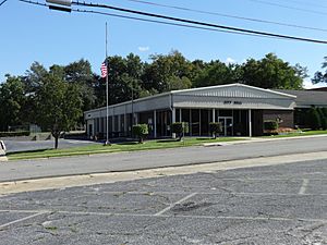
McRae-Helena City Hall
|
|

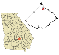
Location in Telfair County and the state of Georgia
|
|
| Country | United States |
| State | Georgia |
| County | Telfair |
| Area | |
| • Total | 4.4 sq mi (11.4 km2) |
| • Land | 4.3 sq mi (11.2 km2) |
| • Water | 0.08 sq mi (0.2 km2) |
| Elevation | 246 ft (75 m) |
| Population
(2010)
|
|
| • Total | 5,740 |
| • Density | 1,322/sq mi (510.4/km2) |
| Time zone | UTC-5 (Eastern (EST)) |
| • Summer (DST) | UTC-4 (EDT) |
| ZIP code |
31055
|
| Area code(s) | 229 |
| FIPS code | 13-49084 |
| GNIS feature ID | 0317973 |
McRae was a city in Georgia, United States. It was the main town, also called the county seat, of Telfair County. McRae became the county seat in 1871. It started a year earlier as a stop on the Macon and Brunswick Railroad. In 2015, McRae joined with the nearby town of Helena. The new combined city is now called McRae-Helena. This new city is the county seat.
In 2010, McRae had a population of 5,740 people. This number was much higher than in 2000 (2,682 people). The reason for this growth was that the city's borders expanded. This expansion included the area and people from the McRae Correctional Institution. This prison is privately owned and run by a company called CoreCivic. It is a low-security prison for adult men.
Contents
History of McRae
McRae began in 1870. It was the eleventh station on the Macon and Brunswick Railroad line. In 1871, McRae became the county seat for Telfair County. Before this, the county seat was Jacksonville. McRae officially became a town on March 3, 1874. It was named after the McRae family, who were early settlers from Scotland. Daniel M. McRae owned the land where the town was built.
For many years, the county's economy relied on cotton farms. McRae became an important place for trading goods. In 1902, McRae officially became a city. In the early 2000s, McRae and Telfair County agreed to build a private prison. They believed it would create jobs for local people. The McRae Correctional Facility opened in 2003. It is a low-security prison for adult men. CCA (now CoreCivic) has owned and operated it since it opened.
Geography of McRae
McRae is located in the northern part of Telfair County. Its exact location is at 32 degrees, 3 minutes, 52 seconds North and 82 degrees, 53 minutes, 54 seconds West. The town of Helena is to the northwest.
Several major U.S. highways go through McRae. U.S. Routes 23 and 341 run through the city as Oak Street. They lead northwest about 20 miles to Eastman and southeast about 24 miles to Hazlehurst. U.S. Routes 280, 319, and 441 pass through as Third Avenue. These roads cross US 23/341 in the middle of town. US 280 goes northeast about 33 miles to Vidalia and west about 55 miles to Cordele. US 319/441 goes south about 19 miles to Jacksonville and north about 35 miles to Dublin.
The city covers a total area of about 11.4 square kilometers (4.4 square miles). Most of this area, about 11.2 square kilometers (4.3 square miles), is land. The rest, about 0.2 square kilometers (0.1 square miles), is water. The Little Ocmulgee River flows just outside the city limits to the northeast.
Fun Places to Visit
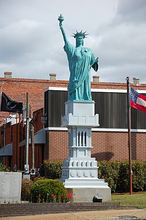
In downtown McRae, you can find Liberty Square. This square has a smaller copy of the famous Statue of Liberty. This replica is one-twelfth the size of the original statue in New York. Liberty Square also has a copy of the Liberty Bell. There is also a marble memorial here. It honors people from Telfair County who died while serving in the military.
On the edge of McRae is the Talmadge Home. This old house was once home to two former governors of Georgia: Eugene Talmadge and Herman Eugene Talmadge. McRae was also the birthplace of Marion B. Folsom (1893–1976). He was a long-time leader at the Eastman Kodak Company. He also served as the United States Secretary of Health, Education, and Welfare during the time Dwight D. Eisenhower was president.
Education
Telfair County School District
The Telfair County School District serves students from pre-school up to the twelfth grade. The district has one elementary school, one middle school, and one high school. There are 112 full-time teachers. Over 1,648 students attend schools in the district.
- Telfair County Elementary School
- Telfair County Middle School
- Telfair County High School
Population Data
| Historical population | |||
|---|---|---|---|
| Census | Pop. | %± | |
| 1900 | 1,020 | — | |
| 1910 | 1,160 | 13.7% | |
| 1920 | 1,273 | 9.7% | |
| 1930 | 1,314 | 3.2% | |
| 1940 | 1,595 | 21.4% | |
| 1950 | 1,904 | 19.4% | |
| 1960 | 2,738 | 43.8% | |
| 1970 | 3,151 | 15.1% | |
| 1980 | 3,409 | 8.2% | |
| 1990 | 3,007 | −11.8% | |
| 2000 | 2,682 | −10.8% | |
| 2010 | 5,740 | 114.0% | |
| 2020 | 6,253 | 8.9% | |
| U.S. Decennial Census | |||
According to the census from 2000, there were 2,682 people living in McRae. There were 1,057 households, which means groups of people living together. Out of these, 714 were families. The population density was about 796.7 people per square mile.
In the city, about 24.0% of the people were under 18 years old. About 20.9% were 65 years old or older. The average age of people in the city was 40 years.
See also
 In Spanish: McRae (Georgia) para niños
 | Janet Taylor Pickett |
 | Synthia Saint James |
 | Howardena Pindell |
 | Faith Ringgold |


