Jacksonville, Georgia facts for kids
Quick facts for kids
Jacksonville, Georgia
|
|
|---|---|

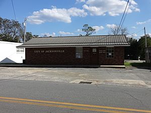
Jacksonville City Hall, police station
|
|

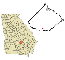
Location in Telfair County and the state of Georgia
|
|
| Country | United States |
| State | Georgia |
| County | Telfair |
| Area | |
| • Total | 1.12 sq mi (2.89 km2) |
| • Land | 1.09 sq mi (2.81 km2) |
| • Water | 0.03 sq mi (0.08 km2) |
| Elevation | 207 ft (63 m) |
| Population
(2020)
|
|
| • Total | 111 |
| • Density | 102.12/sq mi (39.43/km2) |
| Time zone | UTC-5 (Eastern (EST)) |
| • Summer (DST) | UTC-4 (EDT) |
| ZIP code |
31544
|
| Area code(s) | 229 |
| FIPS code | 13-41708 |
| GNIS feature ID | 0316026 |
| Website | https://www.jacksonvillega.gov/ |
Jacksonville is a small city in Telfair County, Georgia, in the United States. In 2020, about 111 people lived there.
Contents
History of Jacksonville
Jacksonville was once the main town for Telfair County. This means it was the "county seat", where the county government was located.
Becoming the County Seat
In 1814, a specific piece of land was chosen to be the permanent county seat. On November 25, 1815, the state of Georgia officially named this new county seat Jacksonville. It was named after Andrew Jackson, a famous hero from the Battle of New Orleans.
Changes Over Time
When Jacksonville was first named, it was in the middle of Telfair County. But in 1854, a new county called Coffee County was created. This new county took some land from Telfair County, which made Jacksonville closer to the edge of Telfair County.
In 1856, people voted to decide if the county seat should move. We don't know the exact results of that vote. However, Jacksonville stayed the county seat until after the American Civil War.
Moving the County Seat
In 1871, the county seat was moved from Jacksonville to McRae. McRae had become a busy train station town just a year before.
A Famous Fish Story
Something very cool happened near Jacksonville! On June 2, 1932, a man named George Perry caught the world record largemouth bass fish here.
Geography of Jacksonville
Jacksonville is located at coordinates 31°48′48″N 82°58′31″W / 31.81333°N 82.97528°W. This helps us find it on a map.
Area of the City
The United States Census Bureau says that Jacksonville covers about 1.1 square miles (2.8 square kilometers). All of this area is land.
Population of Jacksonville
The number of people living in Jacksonville has changed over the years. Here's a look at the population at different times:
| Historical population | |||
|---|---|---|---|
| Census | Pop. | %± | |
| 1850 | 119 | — | |
| 1870 | 40 | — | |
| 1960 | 236 | — | |
| 1970 | 227 | −3.8% | |
| 1980 | 206 | −9.3% | |
| 1990 | 128 | −37.9% | |
| 2000 | 118 | −7.8% | |
| 2010 | 140 | 18.6% | |
| 2020 | 111 | −20.7% | |
| U.S. Decennial Census | |||
Recent Population Numbers
In the year 2000, there were 118 people living in Jacksonville. These people lived in 49 different homes, and 32 of those homes were families. By 2020, the population had changed slightly to 111 people.
See also
 In Spanish: Jacksonville (Georgia) para niños
 | Kyle Baker |
 | Joseph Yoakum |
 | Laura Wheeler Waring |
 | Henry Ossawa Tanner |

