Lumber City, Georgia facts for kids
Quick facts for kids
Lumber City, Georgia
|
|
|---|---|

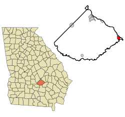
Location in Telfair County and the state of Georgia
|
|
| Country | United States |
| State | Georgia |
| County | Telfair |
| Area | |
| • Total | 1.94 sq mi (5.02 km2) |
| • Land | 1.93 sq mi (4.99 km2) |
| • Water | 0.01 sq mi (0.03 km2) |
| Elevation | 138 ft (42 m) |
| Population
(2020)
|
|
| • Total | 967 |
| • Density | 502.08/sq mi (193.90/km2) |
| Time zone | UTC-5 (Eastern (EST)) |
| • Summer (DST) | UTC-4 (EDT) |
| ZIP code |
31549
|
| Area code(s) | 912 |
| FIPS code | 13-47952 |
| GNIS feature ID | 0356372 |
Lumber City is a small city located in Telfair County, Georgia, in the United States. It's known for its history tied to the timber industry. As of the 2020 census, about 967 people lived there.
Contents
History of Lumber City
The Georgia General Assembly officially made Lumber City a town in 1889. This means it was given the legal right to govern itself. The community got its name because there was a sawmill very close to where the town first started. Sawmills are places where logs are cut into lumber, which is wood used for building and other purposes.
Geography of Lumber City
Lumber City is located in the state of Georgia. Its exact location is 31 degrees, 55 minutes, 48 seconds North, and 82 degrees, 41 minutes, 1 second West.
Main Roads and Highways
The main roads that go through Lumber City are U.S. Route 23 and U.S. Route 341. These roads connect Lumber City to other towns. For example, they lead northwest about 17 miles (27 km) to McRae-Helena. This town is the county seat for Telfair County, meaning it's where the county government is located. The roads also go southeast about 7 miles (11 km) to Hazlehurst. Other important state roads that pass through the city include Georgia State Route 19 and Georgia State Route 117.
City Size and Rivers
According to the United States Census Bureau, Lumber City covers a total area of about 1.9 square miles (5.0 square kilometers). Almost all of this area is land.
Lumber City is special because it's located where two rivers meet. The Ocmulgee River and the Oconee River flow together here. When they combine, they form a new, larger river called the Altamaha River.
Population of Lumber City
The number of people living in Lumber City has changed over the years. Here's a look at the population from different census counts:
| Historical population | |||
|---|---|---|---|
| Census | Pop. | %± | |
| 1890 | 471 | — | |
| 1900 | 760 | 61.4% | |
| 1910 | 1,195 | 57.2% | |
| 1920 | 978 | −18.2% | |
| 1930 | 1,043 | 6.6% | |
| 1940 | 1,044 | 0.1% | |
| 1950 | 1,232 | 18.0% | |
| 1960 | 1,360 | 10.4% | |
| 1970 | 1,377 | 1.3% | |
| 1980 | 1,426 | 3.6% | |
| 1990 | 1,429 | 0.2% | |
| 2000 | 1,247 | −12.7% | |
| 2010 | 1,328 | 6.5% | |
| 2020 | 967 | −27.2% | |
| U.S. Decennial Census 1850-1870 1870-1880 1890-1910 1920-1930 1940 1950 1960 1970 1980 1990 2000 2010 2020 |
|||
As of the 2020 United States census, there were 967 people living in Lumber City. These people lived in 494 households, and 268 of these were families.
See also

- In Spanish: Lumber City (Georgia) para niños
 | Misty Copeland |
 | Raven Wilkinson |
 | Debra Austin |
 | Aesha Ash |

