Pulaski County, Georgia facts for kids
Quick facts for kids
Pulaski County
|
|
|---|---|

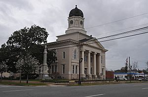
Pulaski County Courthouse
|
|

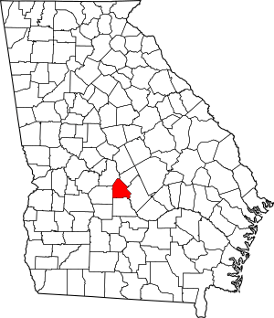
Location within the U.S. state of Georgia
|
|
 Georgia's location within the U.S. |
|
| Country | |
| State | |
| Founded | December 13, 1808 |
| Named for | Kazimierz Pułaski |
| Seat | Hawkinsville |
| Largest city | Hawkinsville |
| Area | |
| • Total | 251 sq mi (650 km2) |
| • Land | 249 sq mi (640 km2) |
| • Water | 2.2 sq mi (6 km2) 0.9%% |
| Population
(2020)
|
|
| • Total | 9,855 |
| • Estimate
(2023)
|
10,095 |
| • Density | 39.26/sq mi (15.160/km2) |
| Time zone | UTC−5 (Eastern) |
| • Summer (DST) | UTC−4 (EDT) |
| Congressional district | 8th |
Pulaski County is a county located in the central portion of the U.S. state of Georgia. As of the 2020 census, about 9,855 people lived here. The main town and county seat is Hawkinsville.
Contents
History of Pulaski County
Pulaski County was officially created on December 13, 1808. It was formed from a part of Laurens County. Before the American Civil War, this area was known for growing cotton. It is part of a region in Georgia called the Black Belt, which has very rich soil.
Over time, parts of Pulaski County were used to create other counties. In 1870, a section became part of Dodge County. Later, in 1912, the northeastern half of Pulaski County was used to form Bleckley County.
The county was named after Count Kazimierz Pułaski. He was a Polish hero who fought and died for the United States during the American Revolutionary War.
Between 1910 and 1930, the number of people living in Pulaski County dropped by more than half. Many residents moved to bigger cities to find work. A large number of African Americans moved north during this time. This movement is known as the Great Migration. They sought better jobs and aimed to escape unfair racial rules in the South.
Geography and Location
Pulaski County covers a total area of about 251 square miles. Most of this area, about 249 square miles, is land. The remaining 2.2 square miles is water. This means about 0.9% of the county is covered by water.
All of Pulaski County is located within the Lower Ocmulgee River area. This river flows into the larger Altamaha River basin.
Major Roads in Pulaski County
Neighboring Counties
Pulaski County shares borders with several other counties:
- Bleckley County to the northeast
- Dodge County to the east
- Wilcox County to the south
- Dooly County to the west
- Houston County to the northwest
Communities in Pulaski County
City
- Hawkinsville (This is the county seat, meaning it's where the county government is located.)
Unincorporated Community
- Hartford (This is a community that is not part of an official city or town.)
Population and People
| Historical population | |||
|---|---|---|---|
| Census | Pop. | %± | |
| 1810 | 2,093 | — | |
| 1820 | 5,283 | 152.4% | |
| 1830 | 4,906 | −7.1% | |
| 1840 | 5,389 | 9.8% | |
| 1850 | 6,627 | 23.0% | |
| 1860 | 8,744 | 31.9% | |
| 1870 | 11,940 | 36.6% | |
| 1880 | 14,058 | 17.7% | |
| 1890 | 16,559 | 17.8% | |
| 1900 | 18,489 | 11.7% | |
| 1910 | 22,835 | 23.5% | |
| 1920 | 11,587 | −49.3% | |
| 1930 | 9,005 | −22.3% | |
| 1940 | 9,829 | 9.2% | |
| 1950 | 8,808 | −10.4% | |
| 1960 | 8,204 | −6.9% | |
| 1970 | 8,066 | −1.7% | |
| 1980 | 8,950 | 11.0% | |
| 1990 | 8,108 | −9.4% | |
| 2000 | 9,588 | 18.3% | |
| 2010 | 12,010 | 25.3% | |
| 2020 | 9,855 | −17.9% | |
| 2023 (est.) | 10,095 | −15.9% | |
| U.S. Decennial Census 1790-1880 1890-1910 1920-1930 1930-1940 1940-1950 1960-1980 1980-2000 2010 |
|||
| Race | Num. | Perc. |
|---|---|---|
| White (non-Hispanic) | 6,022 | 61.11% |
| Black or African American (non-Hispanic) | 3,161 | 32.08% |
| Native American | 8 | 0.08% |
| Asian | 92 | 0.93% |
| Pacific Islander | 3 | 0.03% |
| Other/Mixed | 242 | 2.46% |
| Hispanic or Latino | 327 | 3.32% |
According to the 2020 United States census, there were 9,855 people living in Pulaski County. These people made up 3,687 households and 2,479 families.
See also
 In Spanish: Condado de Pulaski (Georgia) para niños
 | Frances Mary Albrier |
 | Whitney Young |
 | Muhammad Ali |

