Meigs, Georgia facts for kids
Quick facts for kids
Meigs, Georgia
|
|
|---|---|

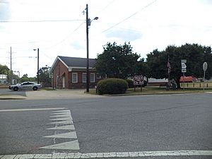
Meigs City Hall and police station
|
|

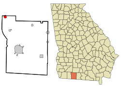
Location in Thomas County and the state of Georgia
|
|
| Country | United States |
| State | Georgia |
| Counties | Thomas, Mitchell |
| Area | |
| • Total | 1.60 sq mi (4.14 km2) |
| • Land | 1.56 sq mi (4.03 km2) |
| • Water | 0.04 sq mi (0.11 km2) |
| Elevation | 341 ft (104 m) |
| Population
(2020)
|
|
| • Total | 928 |
| • Density | 596.40/sq mi (230.30/km2) |
| Time zone | UTC-5 (Eastern (EST)) |
| • Summer (DST) | UTC-4 (EDT) |
| ZIP code |
31765
|
| Area code(s) | 229 |
| FIPS code | 13-50680 |
| GNIS feature ID | 0318004 |
Meigs is a city located in the state of Georgia, United States. Most of the city is in Thomas County, but a small part reaches into Mitchell County. In 2020, about 928 people lived here. This was a bit less than the 1,035 people counted in 2010.
Contents
Meigs: A Look at Its History
The city of Meigs was officially made a town by the Georgia General Assembly in 1889. It was named after a person named William Allen Meigs (1862–1913). He was a successful businessman who dealt with turpentine in the area.
Where is Meigs Located?
Meigs is found in the northwestern part of Thomas County. Its exact location is 31°4′22″N 84°5′28″W / 31.07278°N 84.09111°W. A small piece of the city also extends into Mitchell County.
Size and Water in Meigs
The United States Census Bureau says that Meigs covers a total area of about 1.6 square miles (4.14 square kilometers). Most of this area, about 1.56 square miles (4.03 square kilometers), is land. The rest, about 0.04 square miles (0.11 square kilometers), is water. This means about 2.75% of the city's area is water.
Roads and Travel in Meigs
U.S. Route 19 runs just east of Meigs. This road can take you southeast about 19 miles (30 kilometers) to Thomasville. Thomasville is the main city in Thomas County. If you go northwest on U.S. Route 19, you'll reach Pelham in about 5 miles (8 kilometers).
Georgia State Route 111 goes right through the middle of Meigs. It follows Marshall Street and Depot Street. This route leads northeast about 20 miles (32 kilometers) to Moultrie. If you go southwest on State Route 111, you will arrive at Cairo in about 16 miles (26 kilometers).
People Living in Meigs
The number of people living in Meigs has changed over the years.
| Historical population | |||
|---|---|---|---|
| Census | Pop. | %± | |
| 1900 | 617 | — | |
| 1910 | 697 | 13.0% | |
| 1920 | 1,011 | 45.1% | |
| 1930 | 1,000 | −1.1% | |
| 1940 | 927 | −7.3% | |
| 1950 | 1,125 | 21.4% | |
| 1960 | 1,236 | 9.9% | |
| 1970 | 1,226 | −0.8% | |
| 1980 | 1,231 | 0.4% | |
| 1990 | 1,120 | −9.0% | |
| 2000 | 1,090 | −2.7% | |
| 2010 | 1,035 | −5.0% | |
| 2020 | 928 | −10.3% | |
| U.S. Decennial Census 1850-1870 1870-1880 1890-1910 1920-1930 1940 1950 1960 1970 1980 1990 2000 2010 |
|||
Different Backgrounds in Meigs (2020)
In 2020, there were 928 people living in Meigs. These people lived in 394 households, and 235 of these were families. The table below shows the different racial and ethnic groups that made up the population in 2020.
| Race | Num. | Perc. |
|---|---|---|
| White (not Hispanic) | 255 | 27.48% |
| Black or African American (not Hispanic) | 576 | 62.07% |
| Asian | 3 | 0.32% |
| Other/Mixed | 19 | 2.05% |
| Hispanic or Latino | 76 | 8.08% |
In 2024, the population was estimated to be around 1,035 people. Most of these people, 993, lived in the Thomas County part of Meigs. The remaining 42 people lived in the Mitchell County part.
Schools in Meigs
Students living in the Thomas County part of Meigs go to schools in the Thomas County School District.
Students who live in the Mitchell County part of Meigs attend schools in the Mitchell County School District.
See also

- In Spanish: Meigs para niños
 | Bessie Coleman |
 | Spann Watson |
 | Jill E. Brown |
 | Sherman W. White |

