Eldorendo, Georgia facts for kids
Quick facts for kids
Eldorendo, Georgia
|
|
|---|---|
| Country | |
| State | Georgia |
| County | Decatur County |
| Elevation | 40 m (131 ft) |
| ZIP codes |
39825, 39817, 39837
|
| GNIS feature ID | 0313895 |
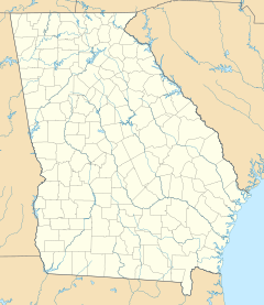
Eldorendo is a small place in Decatur County, located in the southwest part of Georgia, United States. It's known as an unincorporated community, which means it doesn't have its own official city government or mayor. Instead, it's part of the larger county.
Eldorendo is found along major roads like U.S. Route 27 and Georgia State Route 1. It's about halfway between the towns of Colquitt and Bainbridge. Some local roads include Old Eldorendo Road and Church Street. Since it's not an official city, Eldorendo doesn't have its own public services like water or trash collection. Even though it's small, mail for Eldorendo uses three different ZIP codes: 39825, 39817, and 39837.
History of Eldorendo
How Eldorendo Got Its Name
The community of Eldorendo was named after a woman named Eldorendo Virginia Higgs Brown. She was born in 1835 and passed away in 1904. In the 1870s, she and her husband, S. Morgan Brown, moved to this area.
A new railroad line was built through their land. When a post office was going to be opened there, Eldorendo Brown applied to be the Postmistress. This meant she would be in charge of the mail. When she filled out the forms, she signed her full name.
The postal officials noticed that the town didn't have a name yet. They decided to use "Eldorendo" from her first name on the paperwork. That's how the community got its unique name! Eldorendo Brown and her husband are both buried in the Eldorendo Baptist Church Cemetery. After she passed away, her daughter, Ona Brown Pridgen, took over as Postmistress.
The Post Office Story
After Ona Brown Pridgen, Victor Smith became the Postmaster of Eldorendo. The post office eventually closed down in the early to mid-1950s.
However, it was reopened a few years later in the late 1950s. Calista Powell Jester Barrett then ran it. The post office closed again in the late 1960s. This was because fewer people were using it, and better roads made it easier to deliver mail directly to homes in rural areas.
Where is Eldorendo?
Eldorendo is located at a specific point on the map: 31 degrees, 2 minutes, 39 seconds North and 84 degrees, 39 minutes, 7 seconds West. It sits at an elevation of about 131 feet (or 40 meters) above sea level.
 | William M. Jackson |
 | Juan E. Gilbert |
 | Neil deGrasse Tyson |


