
St. Marks River facts for kids
Quick facts for kids St. Marks River |
|
|---|---|

St. Marks River viewed from U.S. Highway 98.
|
|

St. Marks River watershed
|
|
| Country | United States |
| State | Florida |
| Counties | Leon, Jefferson, Wakulla |
| District | NWFWMD |
| Physical characteristics | |
| Main source | Tallahassee Hills Capitola, Florida 30°28′40″N 84°06′01″W / 30.47778°N 84.10028°W |
| River mouth | Apalachee Bay Port Leon, Florida 30°4′53″N 84°11′31″W / 30.08139°N 84.19194°W |
| Length | 36 mi (58 km) |
| Discharge (location 2) |
|
| Basin features | |
| Basin size | 1,150 sq mi (3,000 km2) |
| Tributaries |
|
The St. Marks River is a beautiful river located in the Big Bend area of Florida. It is very special because the Florida Department of Environmental Protection has named it an Outstanding Florida Water. This means the river is protected because it is so important for nature and people. It is also the most eastern river in the Northwest Florida Water Management District.
The St. Marks River starts in eastern Leon County, Florida. It flows for about 36 miles (58 km) through Leon and Wakulla counties. Finally, it empties into Apalachee Bay, which is part of the Gulf of Mexico. The area of land that drains water into the river, called its drainage basin, is about 1,150 square miles (3,000 km2) big. The river has one main branch, called a tributary, which is the Wakulla River.
Contents
How the St. Marks River Flows
A few miles south of where it begins, the St. Marks River flows under a natural bridge. This cool spot is at the Natural Bridge Battlefield Historic State Park. After this, the river actually disappears underground for about half a mile! It becomes a subterranean river, flowing beneath the ground.
The St. Marks River Rise
The river then comes back to the surface at a place called the St. Marks River Rise. This is a very large spring, which means water flows out of the ground here. It's so big that it's called a "first magnitude spring," and a lot of water, about 433 cubic feet per second, comes out. After emerging, the river flows over some rocks, creating small rapids.
Towns and Important Places Along the River
The town of St. Marks is located right where the Wakulla River joins the St. Marks River. North of St. Marks is a community called Newport. There's also a small industrial area between St. Marks and Newport where goods are moved by barges on the river.
Historical and Modern Sites
Near where the river meets the bay, you can find the San Marcos de Apalache Historic State Park. This park has a lot of history. Also nearby is the St. Marks lighthouse, which has guided ships for many years. Further up the river, in St. Marks, is the City of Tallahassee's Sam O. Purdom Generating Plant, which helps provide power.
Images for kids
-
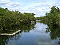
St. Marks River viewed from U.S. Highway 98.
-
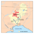
St. Marks River watershed
See also
 In Spanish: Río St. Marks para niños
