Wakulla River facts for kids
The Wakulla River is a beautiful 11-mile (18 km) long river in Wakulla County, Florida. It starts from the amazing Wakulla Springs, which is part of the Edward Ball Wakulla Springs State Park. The river then flows into the St. Marks River, about 3 miles (5 km) north of the Gulf of Mexico. The water in the Wakulla River is super clear and clean!
Because of its clear water, the Wakulla River was once a popular spot for filming underwater movie scenes. This happened during a time when many movies were made in north Florida. Famous films shot here include several Tarzan movies, starring Johnny Weissmuller, and the classic monster movie Creature from the Black Lagoon.
Quick facts for kids Wakulla River |
|
|---|---|

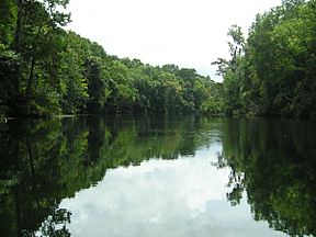
Wakulla River between the Upper and Lower Bridges.
|
|

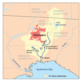
St. Marks River watershed
|
|
| Country | United States |
| State | Florida |
| County | Wakulla |
| District | NWFWMD |
| Physical characteristics | |
| Main source | Wakulla Springs Wakulla Springs State Park 30°14′01″N 84°18′19″W / 30.23361°N 84.30528°W |
| River mouth | St. Marks River St. Marks, Florida 30°8′58″N 84°12′40″W / 30.14944°N 84.21111°W |
| Length | 11 mi (18 km) |
What Does the Name "Wakulla" Mean?
The name Wakulla comes from an old Native American word, Guacara. This word was used by the Spanish when they explored the area. Native American groups like the Seminoles changed the pronunciation over time.
It's hard to know the exact meaning of Wakulla today. It might be related to a word that meant "spring of water" in some Native American languages. Interestingly, the Suwannee River was also once called "Guacara River." Both rivers are fed by large springs, which might be why they shared a similar name.
Exploring the Wakulla River
You can explore part of the Wakulla River by canoe! There's a special Canoe Trail that is about 4 miles (6 km) long. This trail runs between two bridges, called the Upper and Lower Bridges.
Years ago, a fence was put up that blocks access to the river north of the Upper Bridge. A court decided that this part of the river was not considered "navigable" (meaning boats couldn't easily travel on it).
Bridges Over the Wakulla River
Several bridges cross the Wakulla River, helping people travel across it. Here are the main crossings:
| Crossing | Carries | Image | Location | Coordinates |
|---|---|---|---|---|
| Where the River Starts | 30°14′01″N 84°18′19″W / 30.23361°N 84.30528°W | |||
| Upper Bridge | Shadeville Highway |
Wakulla Station | 30°12′49″N 84°15′41″W / 30.21361°N 84.26139°W | |
| Lower Bridge | Coastal Highway |
St. Marks | 30°10′32″N 84°14′43″W / 30.17556°N 84.24528°W | |
| Where the River Ends | 30°08′58″N 84°12′40″W / 30.14944°N 84.21111°W | |||
 | Janet Taylor Pickett |
 | Synthia Saint James |
 | Howardena Pindell |
 | Faith Ringgold |

