
Wakulla County, Florida facts for kids
Quick facts for kids
Wakulla County
|
||
|---|---|---|

Wakulla County Courthouse
|
||
|
||

Location within the U.S. state of Florida
|
||
 Florida's location within the U.S. |
||
| Country | ||
| State | ||
| Founded | March 11, 1843 | |
| Named for | Wakulla River | |
| Seat | Crawfordville | |
| Largest city | Sopchoppy | |
| Area | ||
| • Total | 736 sq mi (1,910 km2) | |
| • Land | 606 sq mi (1,570 km2) | |
| • Water | 129 sq mi (330 km2) 17.6%% | |
| Population
(2020)
|
||
| • Total | 33,764 | |
| • Estimate
(2023)
|
36,449 |
|
| • Density | 45.88/sq mi (17.712/km2) | |
| Time zone | UTC−5 (Eastern) | |
| • Summer (DST) | UTC−4 (EDT) | |
| Congressional district | 2nd | |

Wakulla County is a place in the northern part of Florida, a state in the United States. It's in an area called the Big Bend. In 2020, about 33,764 people lived here. Its main town, or county seat, is Crawfordville. Wakulla County is also part of the larger Tallahassee area. Most people in Wakulla County live outside of towns, with only a small number living in its two small towns.
Contents
Discovering Wakulla County's Past
Early Spanish Explorers
In 1528, a Spanish explorer named Pánfilo de Narváez arrived in what is now Wakulla County. He camped where the Wakulla and St. Marks rivers meet. Narváez thought this was a great spot for a fort. Later, in 1539, another explorer, Hernando de Soto, also traveled through this area.
The Fort San Marcos de Apalache started as a wooden fort in the late 1600s. People didn't settle around the fort until 1733. Spanish officials began building a stone fort, but it wasn't finished when Great Britain took control in the 1760s.
British Rule
The British divided Florida into two parts: East Florida and West Florida. Wakulla County was in East Florida. The Apalachicola River was the border. West Florida stretched all the way to the Mississippi River back then. Twenty years later, when the Spanish returned, they kept these two divisions. The main cities for these areas were St. Augustine and Pensacola.
Spain Returns
The area that became Wakulla County was very active in the early 1800s. A former British officer, William Augustus Bowles, tried to unite 400 Creek Native Americans. He led them against the Spanish fort of San Marcos and captured it. Spain sent ships about five weeks later to get control back.
In 1818, General Andrew Jackson invaded the area and captured Fort San Marcos. Two British citizens, Robert Ambrister and Alexander Arbuthnot, were found guilty of causing Native American raids. They were executed under Jackson's orders. This caused big problems between the U.S. and Britain. The U.S. Army had 200 soldiers at the fort for almost a year (1818–1819).
In 1821, Florida became part of the United States. Fort St. Marks, as the Americans called it, was again guarded by U.S. troops.
Florida Becomes a Territory
In 1824, the fort was no longer used by the military. It was given to the Territory of Florida.
By 1839, the fort was given back to the U.S. government. A hospital for sailors was built there. This hospital also helped people with yellow fever in the area.
American Forts in Wakulla County
- 1840 - Camp Lawson, also called Fort Lawson (2), was northwest of Wakulla.
- 1841-1842 - Fort Many was located near Wakulla Springs.
- 1839 - Fort Number Five (M) was near Sopchoppy.
- 1839-1843 - Fort Stansbury was on the Wakulla River, about 9 miles (14 km) from St. Marks.
- 1841-1843 - Fort Port Leon was destroyed by a hurricane. Later, the Confederate Army used its site for cannons.
- 1839 - James Island Post was on James Island.
Before the Civil War
Wakulla County was created from Leon County in 1843. Its name might come from a Timucuan Native American word. This word could mean "spring of water" or "mysterious water." This refers to Wakulla Springs, one of the world's largest freshwater springs. It's known for its depth and how much water flows from it. In 1974, the water flow was measured at 1.23 billion US gallons (4.66 million cubic meters) per day. This was the biggest flow ever recorded for a single spring.
In 1856, an adventurer named Charles Lanman wrote about the springs:
An adequate idea of this mammoth spring could never be given by pen or pencil; but when once seen, on a bright calm day, it must ever after be a thing to dream about and love. It is the fountain-head of a river... and is of sufficient volume to float a steamboat, if such an affair had yet dared to penetrate this solemn wilderness... It wells up in the very heart of a dense cypress swamp, is nearly round in shape, measures some four hundred feet in diameter, and is in depth about one hundred and fifty feet, having at its bottom an immense horizontal chasm, with a dark portal, from one side of which looms up a limestone cliff, the summit of which is itself nearly fifty feet beneath the spectator, who gazes upon it from the sides of a tiny boat. The water is so astonishlingly clear that even a pin can be seen on the bottom in the deepest places, and of course every animate and inanimate object which it contains is fully exposed to view. The apparent color of the water from the shore is greenish, but as you look perpendicularly into it, it is colorless as air, and the sensation of floating upon it is that of being suspended in a balloon; and the water is so refractive, that when the sun shines brilliantly every object you see is enveloped in the most fascinating prismatic hues.
Another idea for the name Wakulla is that it means "mist" or "misting." This might be about the "Wakulla Volcano." This was a strange event in the 1800s where a column of smoke could be seen rising from the swamp for miles.
The town of Port Leon was once a busy place for shipping cotton. A railroad from Tallahassee brought over 50,000 tons of cotton each year. This cotton was put on ships, usually going straight to Europe. Port Leon was Florida's sixth-largest town, with 1,500 people. But a hurricane and a huge storm surge completely destroyed the town. A new town, New Port (now Newport, Florida), was built 2 miles (3 km) upstream. However, it never became as successful as Port Leon.
The Civil War Years
During the Civil War, the Union Navy blocked Wakulla County from 1861 to 1865. They were at the mouth of the St. Marks River. Confederate soldiers took over the old Spanish fort, San Marcos de Apalache, and renamed it Fort Ward.
The Battle of Natural Bridge stopped Union forces from taking Fort Ward and nearby Tallahassee. Tallahassee was the only Confederate state capital (besides Austin, Texas) that had not been captured. The Union army couldn't land all their soldiers, but they still had more troops than the Confederates. The Confederates decided to fight where the St. Marks River goes underground, at the "Natural Bridge." The Confederate Army had over a day to get ready. The Union Army eventually retreated. Most of the soldiers who died were African-American Union soldiers.
From 1900 to Today
In her book The Other Florida, Gloria Jahoda wrote about how poor Wakulla County was from the early 1900s until 1966. Back then, Wakulla had no doctors or dentists, few stores, and a county newspaper that came out only once a month.
Today, Wakulla County has several doctors and dentists. It also has supermarkets, large stores, a golf resort, and a successful seafood business.
What Does "Wakulla" Mean?
The name Wakulla comes from "Guacara." Guacara is how the Spanish wrote an original Native American name. Wakulla is how the Muskhogean people, like the Seminoles, would say Guacara. The Spanish "Gua" is like the Creek "wa." Since the Creek alphabet doesn't have an "R" sound, "cara" would have been said as "kala" by the Creeks.
Because Wakulla was probably a Timucuan word, we may never know its exact meaning. It might include the word "kala," which meant "spring of water" in some Native American languages. It could also refer to the Whip-poor-will bird, which is called "waxkula" in Creek.
Wakulla County's Location
The U.S. Census Bureau says that Wakulla County covers 736 square miles (1,906 square kilometers). About 606 square miles (1,570 square kilometers) is land, and 129 square miles (334 square kilometers) (17.6%) is water.
Wakulla County became part of the Tallahassee, Florida Metropolitan Statistical Area (MSA) in 1973. It was removed in 1983 but added back again in 2003.
Neighboring Counties
- Leon County - to the north
- Liberty County - to the west
- Franklin County - to the southwest
- Jefferson County - to the east
Protected Natural Areas
- Apalachicola National Forest (part of it)
- St. Marks National Wildlife Refuge (part of it)
State and Local Parks
People of Wakulla County
| Historical population | |||
|---|---|---|---|
| Census | Pop. | %± | |
| 1850 | 1,955 | — | |
| 1860 | 2,839 | 45.2% | |
| 1870 | 2,506 | −11.7% | |
| 1880 | 2,723 | 8.7% | |
| 1890 | 3,117 | 14.5% | |
| 1900 | 5,149 | 65.2% | |
| 1910 | 4,802 | −6.7% | |
| 1920 | 5,129 | 6.8% | |
| 1930 | 5,468 | 6.6% | |
| 1940 | 5,463 | −0.1% | |
| 1950 | 5,258 | −3.8% | |
| 1960 | 5,257 | 0.0% | |
| 1970 | 6,308 | 20.0% | |
| 1980 | 10,887 | 72.6% | |
| 1990 | 14,202 | 30.4% | |
| 2000 | 22,863 | 61.0% | |
| 2010 | 30,776 | 34.6% | |
| 2020 | 33,764 | 9.7% | |
| 2023 (est.) | 36,449 | 18.4% | |
| U.S. Decennial Census 1790-1960 1900-1990 1990-2000 2010-2015 2019 |
|||
In 2020, there were 33,764 people living in Wakulla County. There were 11,382 households and 8,362 families.
Getting Around Wakulla County
Roads
 US 98
US 98 US 319
 SR 61
SR 61 SR 267
 SR 363
Railroads
No trains run in Wakulla County today. But two different railroads used to operate here.
The Georgia, Florida and Alabama Railroad was finished in 1893. It went through Sopchoppy on its way between Tallahassee and Carrabelle. It stopped running in 1948. South of Sopchoppy, the tracks followed H.T. Smith Road. The old railroad bridge over the Ochlocknee River at MacIntyre still has parts standing.
The Tallahassee Railroad was Florida's first railroad, completed in 1836. Its later owner, the Seaboard Coast Line Railroad, stopped using it in 1983. About 16 miles (26 km) of that old railway path became the Tallahassee-St. Marks Historic Railroad State Trail in 1988.
Airports
The Wakulla County Airport (2J0) is south of Panacea. It's a small public airport with one grass runway. This airport was built during World War II. It was an emergency landing strip for Army Air Corps planes. These planes trained and flew along the Gulf Coast. After the war, the county took over the airport for public use.
Seaports
St. Marks is a small port for commercial boats. Panacea and Ochlockonee Bay also have small fishing fleets.
Education in Wakulla County
Wakulla County has its own school district. Here are some of the schools:
- Crawfordville Elementary School
- C.O.A.S.T. Charter School
- Medart Elementary School
- Shadeville Elementary School
- Riversink Elementary School
- Riversprings Middle School
- Wakulla Middle School
- Wakulla High School
- Wakulla Christian School
The old Sopchoppy Elementary School is now the Sopchoppy Education Center. It offers Pre-K, adult, and second-chance education.
The former Shadeville High School served African-American students from 1931 to 1967.
Library
The Wakulla County Public Library is the main library. It is part of the Wilderness Coast Public Libraries system.
Communities in Wakulla County
Towns
Census-Designated Places
- Crawfordville (this is the county seat)
- Panacea
Other Unincorporated Communities
- Arran
- Buckhorn
- Curtis Mills
- Hyde Park
- Ivan
- Medart
- Newport
- Port Leon
- Sanborn
- Shadeville
- Shell Point
- Smith Creek
- Spring Creek
- Wakulla
- Wakulla Beach
Images for kids
-
Wakulla County Seal
-
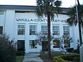
Wakulla County Courthouse
See also
 In Spanish: Condado de Wakulla para niños
