Brantley County, Georgia facts for kids
Quick facts for kids
Brantley County
|
|||
|---|---|---|---|
|
County
|
|||

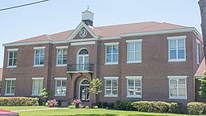
Brantley County Courthouse in Nahunta
|
|||
|
|||

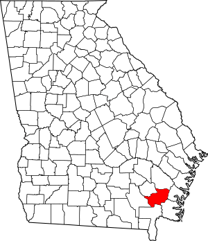
Location within the U.S. state of Georgia
|
|||
 Georgia's location within the U.S. |
|||
| Country | |||
| State | |||
| Founded | 1920 | ||
| Named for | Benjamin Daniel Brantley or William Gordon Brantley | ||
| Seat | Nahunta | ||
| Largest city | Nahunta | ||
| Area | |||
| • Total | 447 sq mi (1,160 km2) | ||
| • Land | 442 sq mi (1,140 km2) | ||
| • Water | 4.8 sq mi (12 km2) 1.1%% | ||
| Population
(2020)
|
|||
| • Total | 18,021 | ||
| • Density | 42/sq mi (16/km2) | ||
| Time zone | UTC−5 (Eastern) | ||
| • Summer (DST) | UTC−4 (EDT) | ||
| Congressional district | 1st | ||
Brantley County is a county located in the southeastern part of the U.S. state of Georgia. As of the 2020 census, about 18,021 people lived there. The main town and county seat is Nahunta. Brantley County is also part of the larger Brunswick metropolitan area.
Contents
History of Brantley County
Georgia voters approved a change to the state's rules on November 2, 1920. This change created Brantley County. The new county was made from parts of three older counties: Charlton, Pierce, and Wayne.
The exact reason for the county's name is not fully known. However, it is thought to honor William Gordon Brantley. He was a U.S. Representative (a member of Congress). Another idea is that it honors his father, Benjamin Daniel Brantley. Benjamin was a well-known local merchant and a soldier in the Confederate States Army during the American Civil War (1861-1865).
Geography of Brantley County
Brantley County covers a total area of about 447 square miles (1,158 square kilometers). Most of this area, about 442 square miles (1,145 square kilometers), is land. The remaining 4.8 square miles (12 square kilometers) is water. This means about 1.1% of the county is water. The Satilla River flows through Brantley County.
Most of Brantley County is in the Satilla River area. This includes areas from east of Hortense south to west of Waynesville, and west to east of Waycross. The eastern edge of the county, near Waynesville, is in a different part of the same river system. A small section in the northwest is in the Little Satilla area. A very small part in the southwest is in the Upper Suwannee River area.
Main Roads in Brantley County
Counties Next to Brantley County
- Wayne County - to the northeast
- Glynn County - to the east
- Camden County - to the southeast
- Charlton County - to the south
- Ware County - to the west
- Pierce County - to the northwest
Towns and Communities
Cities
Census-Designated Places
These are areas that are like towns but are not officially incorporated as cities.
- Hickox
- Hortense
- Waynesville
Unincorporated Communities
These are smaller settlements that are not part of any city or census-designated place.
- Fort Mudge
- Schlatterville
Population of Brantley County
| Historical population | |||
|---|---|---|---|
| Census | Pop. | %± | |
| 1930 | 6,895 | — | |
| 1940 | 6,871 | −0.3% | |
| 1950 | 6,387 | −7.0% | |
| 1960 | 5,891 | −7.8% | |
| 1970 | 5,940 | 0.8% | |
| 1980 | 8,701 | 46.5% | |
| 1990 | 11,077 | 27.3% | |
| 2000 | 14,629 | 32.1% | |
| 2010 | 18,411 | 25.9% | |
| 2020 | 18,021 | −2.1% | |
| 2023 (est.) | 18,401 | −0.1% | |
| U.S. Decennial Census 1790-1880 1890-1910 1920-1930 1930-1940 1940-1950 1960-1980 1980-2000 2010 |
|||
According to the 2020 United States census, there were 18,021 people living in Brantley County. There were 6,823 households and 4,578 families.
Education in Brantley County
The schools in Brantley County are managed by the Brantley County School District.
See also
 In Spanish: Condado de Brantley para niños
 | Lonnie Johnson |
 | Granville Woods |
 | Lewis Howard Latimer |
 | James West |


