Charlton County, Georgia facts for kids
Quick facts for kids
Charlton County
|
||
|---|---|---|

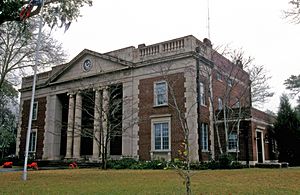
Charlton County Courthouse in Folkston
|
||
|
||

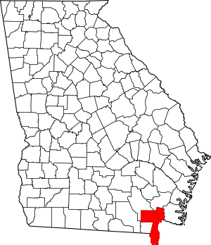
Location within the U.S. state of Georgia
|
||
 Georgia's location within the U.S. |
||
| Country | ||
| State | ||
| Founded | 1854 | |
| Named for | Robert M. Charlton | |
| Seat | Folkston | |
| Largest city | Folkston | |
| Area | ||
| • Total | 782 sq mi (2,030 km2) | |
| • Land | 774 sq mi (2,000 km2) | |
| • Water | 8.8 sq mi (23 km2) 1.1%% | |
| Population
(2020)
|
||
| • Total | 13,392 | |
| • Density | 16.4/sq mi (6.3/km2) | |
| Time zone | UTC−5 (Eastern) | |
| • Summer (DST) | UTC−4 (EDT) | |
| Congressional district | 1st | |
Charlton County is a county in the state of Georgia, located in the southeastern part of the state. It is the southernmost county in Georgia. In 2020, about 12,518 people lived here. The main town and county seat is Folkston.
Contents
History of Charlton County
Charlton County was created on February 18, 1854. It was formed from a part of Camden County. The first county seat was at Trader's Hill. This changed to Folkston in 1901.
More land was added to Charlton County in 1855. This land came from Ware County. The county's borders were adjusted again in 1856.
The county is named after Robert Milledge Charlton. He was a U. S. Senator who represented Georgia.
Geography of Charlton County
Charlton County covers a total area of about 782 square miles. Most of this area, 774 square miles, is land. Only 8.8 square miles, or 1.1%, is water. This makes it the fifth-largest county in Georgia by area.
A big part of the county is covered by the Okefenokee Swamp. This swamp is a protected area by the government.
The central and southern parts of Charlton County are in the St. Marys River area. The northeastern part is in the Satilla River area. The western part is in the Suwannee River area. The southern part of the county is flat. It is at the same level as the northern part of Florida.
Main Roads in Charlton County
 U.S. Route 1
 U.S. Route 23
 U.S. Route 301
 State Route 4
 State Route 15
 State Route 23
 State Route 40
 State Route 40 Connector
 State Route 94
 State Route 121
 State Route 177
 State Route 185
 State Route 252
Nearby Counties
- Brantley County - to the north
- Nassau County, Florida - to the south and east
- Camden County - to the east
- Baker County, Florida - to the south
- Ware County - to the north and west
Protected Areas
- Okefenokee National Wildlife Refuge (part of it is in Charlton County)
Cities and Towns
Small Communities
- Moniac
- Racepond
- Saint George
- Toledo
- Trader's Hill
- Uptonville
Population of Charlton County
| Historical population | |||
|---|---|---|---|
| Census | Pop. | %± | |
| 1860 | 1,780 | — | |
| 1870 | 1,897 | 6.6% | |
| 1880 | 2,154 | 13.5% | |
| 1890 | 3,335 | 54.8% | |
| 1900 | 3,592 | 7.7% | |
| 1910 | 4,722 | 31.5% | |
| 1920 | 4,536 | −3.9% | |
| 1930 | 4,381 | −3.4% | |
| 1940 | 5,256 | 20.0% | |
| 1950 | 4,821 | −8.3% | |
| 1960 | 5,313 | 10.2% | |
| 1970 | 5,680 | 6.9% | |
| 1980 | 7,343 | 29.3% | |
| 1990 | 8,496 | 15.7% | |
| 2000 | 10,282 | 21.0% | |
| 2010 | 12,171 | 18.4% | |
| 2020 | 12,518 | 2.9% | |
| 2023 (est.) | 12,934 | 6.3% | |
| U.S. Decennial Census 1850-1870 1870-1880 1890-1910 1920-1930 1940 1950 1960 1970 1980 1990 2000 2010 2020 |
|||
Here is a table showing the different groups of people living in Charlton County over the years:
| Race / Ethnicity (NH = Not Hispanic) | Pop 2000 | Pop 2010 | Pop 2020 | % 2000 | % 2010 | % 2020 |
|---|---|---|---|---|---|---|
| White alone (NH) | 7,014 | 8,116 | 7,532 | 68.22% | 66.68% | 60.17% |
| Black or African American alone (NH) | 2,990 | 3,443 | 2,386 | 29.08% | 28.29% | 19.06% |
| Native American or Alaska Native alone (NH) | 39 | 38 | 40 | 0.38% | 0.31% | 0.32% |
| Asian alone (NH) | 35 | 76 | 109 | 0.34% | 0.62% | 0.87% |
| Pacific Islander alone (NH) | 6 | 3 | 2 | 0.06% | 0.02% | 0.02% |
| Other race alone (NH) | 3 | 5 | 30 | 0.03% | 0.04% | 0.24% |
| Mixed race or Multiracial (NH) | 114 | 180 | 383 | 1.11% | 1.48% | 3.06% |
| Hispanic or Latino (any race) | 81 | 310 | 2,036 | 0.79% | 2.55% | 16.26% |
| Total | 10,282 | 12,171 | 12,518 | 100.00% | 100.00% | 100.00% |
In 2020, there were 12,518 people living in Charlton County. These people lived in 3,675 households. About 2,685 of these households were families.
Education in Charlton County
The schools in Charlton County are managed by the Charlton County School District.
See also
 In Spanish: Condado de Charlton para niños
 | James Van Der Zee |
 | Alma Thomas |
 | Ellis Wilson |
 | Margaret Taylor-Burroughs |


