
Baker County, Florida facts for kids
Quick facts for kids
Baker County
|
||
|---|---|---|
.jpg)
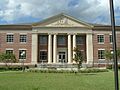
Baker County Courthouse in Macclenny
|
||
|
||

Location within the U.S. state of Florida
|
||
 Florida's location within the U.S. |
||
| Country | ||
| State | ||
| Founded | February 8, 1861 | |
| Named for | James McNair Baker | |
| Seat | Macclenny | |
| Largest city | Macclenny | |
| Area | ||
| • Total | 588.97 sq mi (1,525.4 km2) | |
| • Land | 585.23 sq mi (1,515.7 km2) | |
| • Water | 3.74 sq mi (9.7 km2) | |
| Population
(2020)
|
||
| • Total | 28,259 | |
| • Density | 48.29/sq mi (18.64/km2) | |
| Time zone | UTC−5 (Eastern) | |
| • Summer (DST) | UTC−4 (EDT) | |
| Congressional district | 3rd | |

Baker County is a county located in the state of Florida. In 2020, about 28,259 people lived here. The main town and county seat is Macclenny.
The county was started in 1861. It was named after James McNair Baker. He was a judge and a senator for the Confederate States. Baker County is part of the larger Jacksonville area.
A very important event happened here in 1864. The Battle of Olustee was fought in Baker County. This was the only major American Civil War battle in Florida.
Contents
History of Baker County
Baker County was created in 1861. It was named to honor James McNair Baker. He was a judge and a senator during the American Civil War.
In 1864, a big battle took place in the county. This was the Battle of Olustee. It was the only major Civil War battle fought in Florida.
Geography and Nature
Baker County covers about 589 square miles. Most of this area is land. A small part, about 3.7 square miles, is water.
The northern part of the county touches the Okefenokee Swamp. This swamp is a large, protected natural area. Baker County is also home to the St. Marys River. This river is a quiet, dark-water stream. It forms part of the border between Florida and Georgia.
Neighboring Counties
Baker County shares borders with several other counties:
- Charlton County, Georgia - to the north
- Ware County, Georgia - to the north
- Nassau County, Florida - to the northeast
- Duval County, Florida - to the east
- Clay County, Florida - to the southeast
- Union County, Florida - to the south
- Bradford County, Florida - to the south
- Columbia County, Florida - to the west
- Clinch County, Georgia - to the northwest
Protected Natural Areas
Parts of two important national protected areas are in Baker County:
Travel and Roads
Baker County has several important roads and railways. They help people and goods move around.
Main Highways
 I-10: This is the main highway going from west to east. It divides the county into northern and southern parts. It has five exits in Baker County.
 US 90: This road used to be the main east-west route. Now, Interstate 10 is the primary one.
 SR 2: This road goes from west to east in the northwest part of the county. It crosses into Georgia.
 SR 121: This road goes from south to north. It passes through Macclenny and then continues into Georgia.
 SR 228: This is a shorter state road in Macclenny. It also has county road parts that extend it.
Railroads
Railroads are important for moving goods.
- The Florida Gulf & Atlantic Railroad runs through the county.
- The Norfolk Southern Railway also has a line here. It goes from the Okefenokee National Wildlife Refuge to Jacksonville.
- A former railroad line, the Jacksonville and Southwestern Railroad, was closed in 1992. Part of it has been turned into a walking and biking trail.
People of Baker County
| Historical population | |||
|---|---|---|---|
| Census | Pop. | %± | |
| 1870 | 1,325 | — | |
| 1880 | 2,303 | 73.8% | |
| 1890 | 3,333 | 44.7% | |
| 1900 | 4,516 | 35.5% | |
| 1910 | 4,805 | 6.4% | |
| 1920 | 5,622 | 17.0% | |
| 1930 | 6,273 | 11.6% | |
| 1940 | 6,510 | 3.8% | |
| 1950 | 6,313 | −3.0% | |
| 1960 | 7,363 | 16.6% | |
| 1970 | 9,242 | 25.5% | |
| 1980 | 15,289 | 65.4% | |
| 1990 | 18,486 | 20.9% | |
| 2000 | 22,259 | 20.4% | |
| 2010 | 27,115 | 21.8% | |
| 2020 | 28,259 | 4.2% | |
| 2023 (est.) | 28,368 | 4.6% | |
| U.S. Decennial Census 1790–1960 1900–1990 1990–2000 2010–2020 |
|||
In 2020, Baker County had 28,259 people living there. There were 8,828 households, which are groups of people living together.
Most people in Baker County are White. There is also a significant Black or African American population. Other groups include Native American, Asian, and people of mixed backgrounds. About 3.4% of the population is Hispanic or Latino.
In 2000, the average age of people in the county was 34 years old. About 27.5% of the population was under 18.
Education in Baker County
The Baker County School District manages all the public schools in the county.
The main library is the Emily Taber Public Library. This building used to be the Old Baker County Courthouse. It was built in 1908.
Industries and Jobs
Baker County has various industries. There are also several correctional facilities in the western part of the county. These include local, state, and federal prisons. One example is the Baker Correctional Institution.
Towns and Communities
City
Town
Unincorporated Communities
Images for kids
-
Baker County Courthouse in Macclenny
See also
 In Spanish: Condado de Baker (Florida) para niños
