
Bradford County, Florida facts for kids
Quick facts for kids
Bradford County
|
||
|---|---|---|

Bradford County Courthouse
|
||
|
||

Location within the U.S. state of Florida
|
||
 Florida's location within the U.S. |
||
| Country | ||
| State | ||
| Founded | December 31, 1858 | |
| Seat | Starke | |
| Largest city | Starke | |
| Area | ||
| • Total | 300 sq mi (800 km2) | |
| • Land | 294 sq mi (760 km2) | |
| • Water | 6.5 sq mi (17 km2) 2.2%% | |
| Population
(2020)
|
||
| • Total | 28,303 | |
| • Density | 91/sq mi (35/km2) | |
| Time zone | UTC−5 (Eastern) | |
| • Summer (DST) | UTC−4 (EDT) | |
| Congressional district | 3rd | |

.jpg)
Bradford County is a county located in the north central part of Florida, a state in the United States. In 2020, about 28,303 people lived there. The main city and county seat is Starke.
Contents
History of Bradford County
How Bradford County Started
Bradford County was first created in 1858. It was called New River County back then. Parts of Columbia and Alachua counties were used to form it. In 1861, its name changed to Bradford County. This was to honor Captain Richard Bradford. He was a soldier who fought in the American Civil War. He was the first officer from Florida to die in that war.
The County Seat's Journey
When the county was new, Lake Butler was its county seat. This is where the county government was located. But Starke started to grow. It became an important city because of a railroad. So, in 1875, people voted to move the county seat to Starke. Starke won by a small number of votes.
However, there was a legal challenge. The county seat moved back to Lake Butler. In 1885, another vote happened. This vote also said Lake Butler should be the county seat. But in 1887, yet another vote took place. This time, the county seat moved back to Starke for good.
This argument about the county seat was a big deal. In 1921, the western part of Bradford County, including Lake Butler, became its own county. This new county was named Union County.
Farming and Growth
In its early days, Bradford County had many citrus farms. But a very cold winter in 1894-1895, called the Great Freeze, damaged them. After that, Starke and Lawtey still grew a lot of crops. They were known for cotton, tobacco, and strawberries.
The county grew a lot during World War II. A major road, U.S. Route 301, was built. Also, a military training camp called Camp Blanding was nearby.
After the war, the Florida State Prison was built near the county line.
Geography of Bradford County
Bradford County covers about 300 square miles (777 square kilometers). Most of this area, about 294 square miles (761 square kilometers), is land. The rest, about 6.5 square miles (17 square kilometers), is water. It is one of the smallest counties in Florida.
Neighboring Counties
Bradford County shares borders with several other counties:
- Baker County, Florida to the north
- Clay County, Florida to the east
- Putnam County, Florida to the southeast
- Alachua County, Florida to the south
- Union County, Florida to the west
- Duval County, Florida to the northeast
Protected Natural Areas
A part of the Osceola National Forest is located in Bradford County. This is a large protected area of nature.
Getting Around Bradford County
Bradford County does not have any major interstate highways. The closest one is I-75, which is west of the county.
 US 301
 SR 16
SR 16 SR 18
SR 18 SR 21
SR 21 SR 100
 SR 200
 SR 230
 SR 231
 SR 235
The county shares Keystone Heights Airport with Clay County. For bigger flights, people use Gainesville Regional Airport or Jacksonville International Airport.
People of Bradford County (Demographics)
| Historical population | |||
|---|---|---|---|
| Census | Pop. | %± | |
| 1860 | 3,820 | — | |
| 1870 | 3,671 | −3.9% | |
| 1880 | 6,112 | 66.5% | |
| 1890 | 7,516 | 23.0% | |
| 1900 | 10,295 | 37.0% | |
| 1910 | 14,090 | 36.9% | |
| 1920 | 12,503 | −11.3% | |
| 1930 | 9,405 | −24.8% | |
| 1940 | 8,717 | −7.3% | |
| 1950 | 11,457 | 31.4% | |
| 1960 | 12,446 | 8.6% | |
| 1970 | 14,625 | 17.5% | |
| 1980 | 20,023 | 36.9% | |
| 1990 | 22,515 | 12.4% | |
| 2000 | 26,088 | 15.9% | |
| 2010 | 28,520 | 9.3% | |
| 2020 | 28,303 | −0.8% | |
| 2023 (est.) | 27,858 | −2.3% | |
| U.S. Decennial Census 1790-1960 1900-1990 1990-2000 2010-2015 |
|||
In 2020, there were 28,303 people living in Bradford County. There were 9,318 households. About 5,882 of these were families.
Most people in Bradford County are White. A large number are also Black or African American. There are also smaller groups of Native American, Asian, and other races. Some people are of Hispanic or Latino background.
In 2000, the average household had about 2.58 people. The average family had about 3.01 people. About 31.9% of households had children under 18. The median age in the county was 37 years old.
The median income for a household was $33,140. For a family, it was $39,123. About 14.6% of the population lived below the poverty line.
Education in Bradford County
The Bradford County School District manages all the public schools in the county. Bradford High School is the main public high school for students.
The main library for the county is the Bradford County Public Library. It is located in Starke. As of 2023, Robert E. Perone is the library director.
Communities in Bradford County
Cities
Town
Images for kids
-
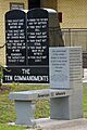
American Atheists bench and Ten Commandments display at the courthouse

-
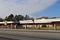
Bradford High School
-
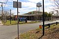
Bradford County Public Library


See also
 In Spanish: Condado de Bradford (Florida) para niños
