Brooker, Florida facts for kids
Quick facts for kids
Brooker, Florida
|
|
|---|---|
| Town of Brooker | |

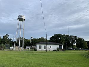
Brooker Water Tower
|
|

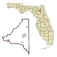
Location in Bradford County and the state of Florida
|
|
| Country | |
| State | |
| County | Bradford |
| Settled (Ward City) | 1838 |
| Settled (Vandy) | April 17, 1893-August 23, 1894 |
| Unincorporated (Brooker) | August 24, 1894 |
| Incorporated (Town of Brooker) |
1952 |
| Government | |
| • Type | Mayor-Council |
| Area | |
| • Total | 0.53 sq mi (1.37 km2) |
| • Land | 0.53 sq mi (1.37 km2) |
| • Water | 0.00 sq mi (0.00 km2) |
| Elevation | 128 ft (39 m) |
| Population
(2020)
|
|
| • Total | 322 |
| • Density | 611.01/sq mi (235.81/km2) |
| Time zone | UTC-5 (Eastern (EST)) |
| • Summer (DST) | UTC-4 (EDT) |
| ZIP code |
32622
|
| Area code(s) | 352 |
| FIPS code | 12-08725 |
| GNIS feature ID | 0279434 |
Brooker is a small town located in Bradford County, Florida, in the United States. It is part of the North central Florida area. In 2020, about 322 people lived there.
Contents
History of Brooker
Brooker has an interesting history with a few name changes.
Early Settlement and Name Changes
In 1838, the area was first known as Ward City. It was named after an early settler, E. P. Ward. Later, in 1892, a man named Thomas R. Collins asked for a US Post Office to be set up there. He became the local postmaster in 1894.
For a short time, from April 17, 1893, to August 23, 1894, the post office was called Vandy. But soon after, on August 24, 1894, it was renamed Brooker.
Why the Name "Brooker"?
Thomas Collins decided to rename the post office after an old bridge. This bridge crossed the Santa Fe River and was named after an early local farmer, Ed Brooker. Most people living in the area liked the name "Brooker" better than "Ward City." This led to Collins' decision to change the name.
Becoming an Official Town
The Town of Brooker officially became a municipality (an organized town with its own government) in 1952.
Geography of Brooker
Brooker is located in the western part of Bradford County. Its exact location is 29°53′20″N 82°19′53″W / 29.88889°N 82.33139°W.
Location and Nearby Areas
The town is about 17 miles (27 km) west of Starke, which is the main city and county seat of Bradford County. A part of the Santa Fe River flows through the town. Also, Florida State Road 235 runs through Brooker, making it easy to travel to and from the town.
Size of the Town
According to the United States Census Bureau, Brooker covers a total area of about 0.53 square miles (1.4 square kilometers). All of this area is land.
Climate in Brooker
Brooker has a climate known as a humid subtropical climate. This means the area experiences hot and humid summers. The winters are generally mild, not too cold.
Population and People
Brooker is a small community. The number of people living in the town has changed over the years.
Population Changes Over Time
Here's how the population of Brooker has changed according to the U.S. Census:
| Historical population | |||
|---|---|---|---|
| Census | Pop. | %± | |
| 1950 | 277 | — | |
| 1960 | 292 | 5.4% | |
| 1970 | 340 | 16.4% | |
| 1980 | 429 | 26.2% | |
| 1990 | 312 | −27.3% | |
| 2000 | 352 | 12.8% | |
| 2010 | 338 | −4.0% | |
| 2020 | 322 | −4.7% | |
| U.S. Decennial Census | |||
In 2020, there were 322 people living in Brooker. There were 113 households and 82 families in the town. In 2010, there were 338 people, with 142 households and 104 families.
See also
 In Spanish: Brooker (Florida) para niños
Images for kids
 | Delilah Pierce |
 | Gordon Parks |
 | Augusta Savage |
 | Charles Ethan Porter |


