
Santa Fe River (Florida) facts for kids
Quick facts for kids Santa Fe |
|
|---|---|

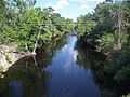
Santa Fe River, north of High Springs
|
|

Santa Fe River Drainage Basin
|
|
| Country | United States |
| State | Florida |
| Cities | Keystone Heights, Branford |
| Physical characteristics | |
| Main source | Lake Santa Fe Keystone Heights, Florida |
| River mouth | Suwannee River Branford, Florida |
| Length | 75 mi (121 km) |
| Basin features | |
| Basin size | 1,380 sq mi (3,600 km2) |
The Santa Fe River is a 75-mile long river in northern Florida. It flows through many areas, including parts of Columbia, Suwannee, and Alachua counties. The river starts from Lake Santa Fe, which is near Keystone Heights.
The Santa Fe River usually flows slowly. Because it moves slowly and has many leaves falling into it, especially from Bald Cypress trees, the water often looks dark brown. This color comes from natural substances called tannins, which are like the ones found in tea.
A River That Disappears
The Santa Fe River is very unique because it completely disappears underground! This happens in a special area called karst region. The river flows into a large sinkhole in O'Leno State Park. Then, about 3 miles (5 km) downstream, it reappears in the nearby River Rise Preserve State Park.
The land above this underground section of the river is known as a natural bridge. Long ago, people used this natural bridge as a main path. It was part of the Spanish mission trail and the Bellamy Road. This allowed travelers to avoid crossing the river directly.
Amazing Springs and Wildlife
Many beautiful springs flow into the Santa Fe River. These include Gilchrist Blue, Ginnie, Hornsby, Lily, Poe, and Rum Island springs. Most of these springs are located downstream from where the river reappears above ground.
The water from these springs is always about 72 degrees Fahrenheit (22 degrees Celsius). This constant temperature makes parts of the river a great home for animals like manatees.
The area around the river is not very crowded with people. This means you might spot amazing wildlife! Animals like the black bear, bobcat, and even the rare Florida panther have been seen here. Just like many rivers in Florida, you can also find many plant and animal fossils along the Santa Fe River.
River Connections
The Santa Fe River has several smaller rivers and creeks that flow into it. These are called tributaries. Some of its tributaries include the New River, Olustee Creek, and the Ichetucknee River. The Ichetucknee River is another river that is fed by springs.
Finally, the Santa Fe River flows into the Suwannee River near Branford, Florida. The name "Santa Fe" comes from an old Spanish mission called Santa Fé de Toloca, which was once located near the river.
Images for kids
-
A bridge over the Santa Fe River
-
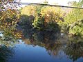
The Santa Fe River near High Springs
-

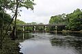
US-27 bridge crossing the Santa Fe River
-
FL-47 bridge over the Santa Fe River


