El Camino Real (Florida) facts for kids
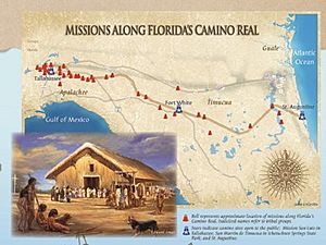
El Camino Real, which means "The Royal Road" or "The King's Highway" in Spanish, was an important path in Florida. The Spanish created this trail in the 1680s. It mostly followed older paths used by Native Americans. The trail stretched from St. Augustine in the east to Spanish missions in north Florida.
Before this road, travel across Florida between the western missions and St. Augustine was difficult. People mostly used water routes. Goods like crops from the Apalachee area were carried by canoes. They went to the Gulf of Mexico and then up rivers like the Suwannee River and Santa Fe River. From there, people or pack animals carried the goods the rest of the way overland. Important supplies and money for the colony also traveled this route in reverse.
Contents
Why Was El Camino Real Needed?
For a long time, moving goods and money across Florida was a big challenge for the Spanish. The main way was by boat, which could be slow and risky.
The Idea for a New Route
In 1673, a Franciscan friar named Juan Moreno had an idea. He suggested that the "situado" (pronounced see-TOO-ah-doh), which was money sent yearly from Spain to support the colony, should travel differently. He thought it could come overland from Veracruz, Mexico, to Apalachee, and then to St. Augustine.
Challenges of the Overland Route
However, this idea was not followed. The route Moreno suggested went through lands of Native American tribes who were not always friendly with the Spanish. Also, the "situado" was silver coins, which would be very heavy to carry. It would be hard to move them across swamps, forests, and large rivers without bridges. Wagons or mule trains could not easily pass through these areas.
Building the Royal Road
Even though the earlier idea for a new route was not used, the Spanish still wanted a better way to connect their settlements.
Governor Quiroga's Plan
In the 1680s, Florida's Governor Diego de Quiroga y Losada decided to build a proper road. He hired an engineer named Enrique Primo de Rivera for the job. The goal was to create a road strong enough for oxcarts.
The Unfinished Project
The project was never fully finished as planned. However, people and goods still used this main path. It became known as El Camino Real. It helped connect the capital city of St. Augustine with the western parts of Spanish Florida.
Was It a True Highway?
Sometimes, people think of El Camino Real as a grand highway connecting all of Spanish Florida. But this isn't quite right.
A Series of Trails
The Spanish did have a loose connection of trails. These paths linked their settlements in Florida to other Spanish areas further west, like California. But it was not a continuous, well-built road.
Difficult Journeys
Much of the path, especially near the Gulf of Mexico, was just Native American foot trails. These trails often ran along high ground. They were frequently broken up by large bodies of water and rivers without bridges or ferries. So, calling it a "highway" would be an exaggeration.
Other Roads in Florida
The Spanish did not build many roads south of St. Augustine.
The King's Road
Some stories say the Spanish built a road to New Smyrna in 1632, but this is incorrect. The area where New Smyrna Beach is today was wild and empty of Europeans at that time. The town of New Smyrna was actually founded much later, in 1768, by a Scottish doctor named Andrew Turnbull.
The British later built a road called the King's Road. It went from Colerain, Georgia, to New Smyrna. When the Spanish took control of Florida again in 1783, they used this road. However, they did not maintain it very well.
 | James B. Knighten |
 | Azellia White |
 | Willa Brown |


