Santa Fe River (New Mexico) facts for kids
Quick facts for kids Santa Fe River |
|
|---|---|

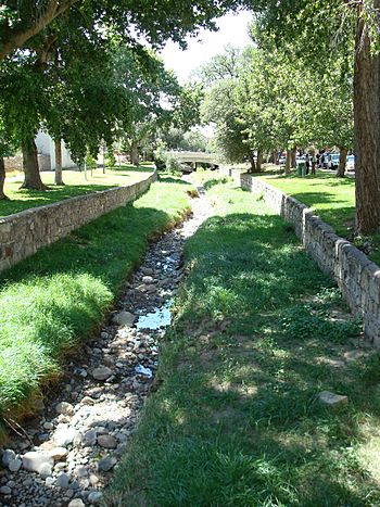
The Santa Fe River as it winds its way through downtown Santa Fe in August 2007.
|
|
| Country | United States |
| State | New Mexico |
| County | Santa Fe, Sandoval |
| Physical characteristics | |
| Main source | Sangre de Cristo Mountains 35°47′21″N 105°46′37″W / 35.78917°N 105.77694°W |
| River mouth | Rio Grande Peña Blanca 35°36′3″N 106°20′23″W / 35.60083°N 106.33972°W |
| Length | 46 mi (74 km) |
| Basin features | |
| Basin size | 285 sq mi (740 km2) |
The Santa Fe River is a river in northern New Mexico, United States. It flows into the Rio Grande, which is a much larger river. The Santa Fe River begins high up in the Sangre de Cristo Mountains and flows through the city of Santa Fe. This river is very important because it provides about 40% of the city's water.
The Santa Fe River is about 46 miles (74 km) long. It's often an intermittent stream, meaning it doesn't always have water flowing in all parts. However, some sections always have water, which are called perennial reaches.
Contents
About the Santa Fe River
The Santa Fe River was first dammed in 1881. This was done to help manage the water supply. Today, the river flows when water is released from two reservoirs by the city of Santa Fe.
Where the River Starts
The river's journey begins in the Sangre de Cristo Mountains. The area that collects water for the river is called its watershed. The Santa Fe River watershed covers about 285 square miles (738 km²). The elevation in this area ranges from very high mountains at 12,408 feet (3,782 m) down to 5,220 feet (1,591 m).
Protecting the River
In 2007, an environmental group called American Rivers named the Santa Fe River "America's most endangered river." This meant the river needed a lot of help to stay healthy. Because of this, the mayor of Santa Fe at the time, David Coss, made bringing the river back to life a top goal for his city.
Santa Fe River Trail
The Santa Fe River Trail is a path for walking and biking. It runs alongside parts of the Santa Fe River. In 2007, the trail existed in small sections within the city and county of Santa Fe. Plans were made to connect these sections to create a longer, continuous trail.
Trail Development and History
The first efforts to build the trail focused on the sections downstream from the city. This area followed the historic El Camino Real de Tierra Adentro. This was an old royal road that approached Santa Fe. One important stop on this old road was in La Cienega. This is now the site of El Rancho de las Golondrinas. Eventually, the trail is planned to stretch 13 miles (21 km) from Patrick Smith Park to NM 599.
Recent Trail Improvements
In the spring of 2012, a new 1.3-mile (2.1 km) section of the trail was finished. This part goes from Camino Alire west to Frenchy's Field Park. Building this section also involved a lot of work to improve the riverbed. They added structures to stop erosion and planted hundreds of cottonwood trees and willows along the path.
There are still two separate parts of the trail further west that need to be connected. One part goes west from the Community Farm at San Ysidro crossing. The other goes north and west from Agua Fria and Dominguez Lane towards the Municipal Recreation Center.
 | Janet Taylor Pickett |
 | Synthia Saint James |
 | Howardena Pindell |
 | Faith Ringgold |

