Columbia County, Florida facts for kids
Quick facts for kids
Columbia County
|
|
|---|---|

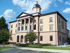
Columbia County Courthouse in Lake City
|
|

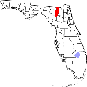
Location within the U.S. state of Florida
|
|
 Florida's location within the U.S. |
|
| Country | |
| State | |
| Founded | February 4, 1832 |
| Named for | Christopher Columbus |
| Seat | Lake City |
| Largest city | Lake City |
| Area | |
| • Total | 801 sq mi (2,070 km2) |
| • Land | 798 sq mi (2,070 km2) |
| • Water | 3.8 sq mi (10 km2) 0.5%% |
| Population
(2020)
|
|
| • Total | 69,698 |
| • Density | 87/sq mi (34/km2) |
| Time zone | UTC−5 (Eastern) |
| • Summer (DST) | UTC−4 (EDT) |
| Congressional district | 3rd |
Columbia County is a special area called a county in the north central part of Florida. It's a great place to live and visit!
In 2020, about 69,698 people lived here. The main city and where the county government is located is Lake City.
Columbia County is part of a larger area that includes Gainesville. A part of the beautiful Osceola National Forest is also found here.
Contents
History of Columbia County
Columbia County was created a long time ago, in 1832. It was named after "Columbia," which is a poetic name for the United States. This name comes from Christopher Columbus.
In 1958, a group of people who loved talking to others around the world formed the Columbia Amateur Radio Society. They used special radios to communicate. This club is still active today!
Geography of Columbia County
Columbia County covers a total area of about 801 square miles. Most of this is land, with a small part being water.
Neighboring Counties
Columbia County shares its borders with several other counties.
- Echols County, Georgia - to the north
- Clinch County, Georgia - to the northeast
- Baker County - to the east
- Union County - to the southeast
- Alachua County - to the south
- Gilchrist County - to the southwest
- Suwannee County - to the west
- Hamilton County - to the northwest
Protected Natural Areas
A part of the Osceola National Forest is located within Columbia County. This forest is a protected area where you can find nature and wildlife.
People of Columbia County (Demographics)
The number of people living in Columbia County has grown a lot over the years.
| Historical population | |||
|---|---|---|---|
| Census | Pop. | %± | |
| 1840 | 2,102 | — | |
| 1850 | 4,808 | 128.7% | |
| 1860 | 4,646 | −3.4% | |
| 1870 | 7,335 | 57.9% | |
| 1880 | 9,589 | 30.7% | |
| 1890 | 12,877 | 34.3% | |
| 1900 | 17,094 | 32.7% | |
| 1910 | 17,689 | 3.5% | |
| 1920 | 14,290 | −19.2% | |
| 1930 | 14,638 | 2.4% | |
| 1940 | 16,859 | 15.2% | |
| 1950 | 18,216 | 8.0% | |
| 1960 | 20,077 | 10.2% | |
| 1970 | 25,250 | 25.8% | |
| 1980 | 35,399 | 40.2% | |
| 1990 | 42,613 | 20.4% | |
| 2000 | 56,513 | 32.6% | |
| 2010 | 67,531 | 19.5% | |
| 2020 | 69,698 | 3.2% | |
| 2023 (est.) | 73,063 | 8.2% | |
| U.S. Decennial Census 1790-1960 1900-1990 1990-2000 2010-2015 2020 |
|||
The county is home to a diverse group of people. In 2020, there were 69,698 people living in Columbia County. There were also 25,205 households.
| Group | Number in 2010 | Number in 2020 | Percent in 2010 | Percent in 2020 |
|---|---|---|---|---|
| White (NH) | 50,475 | 49,096 | 74.74% | 70.44% |
| Black or African American (NH) | 11,663 | 11,441 | 17.27% | 16.42% |
| Native American or Alaska Native (NH) | 316 | 236 | 0.47% | 0.34% |
| Asian (NH) | 611 | 867 | 0.9% | 1.24% |
| Pacific Islander (NH) | 36 | 27 | 0.05% | 0.04% |
| Some Other Race (NH) | 94 | 295 | 0.14% | 0.42% |
| Mixed/Multi-Racial (NH) | 1,060 | 2,673 | 1.57% | 3.84% |
| Hispanic or Latino | 3,276 | 5,063 | 4.85% | 7.26% |
| Total | 67,531 | 69,698 |
In 2000, about 25.40% of the people were under 18 years old. The average age was 37 years old.
Education in Columbia County
The Columbia County School District is in charge of all the public schools in the county.
Libraries
The Columbia County Public Library has three different locations:
- Main Branch
- West Branch
- Fort White Branch
Transportation in Columbia County
Airports
The main airport in Columbia County is the Lake City Municipal Airport. There are also smaller private airports.
Major Roads
Many important roads run through Columbia County:
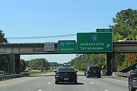
 I-10 is a major highway that goes from west to east. It helps divide the northern and southern parts of the county.
 I-75 is another big highway that goes from southeast to northwest. It connects Columbia County to other areas.
 US 27 is a road in the southwestern part of the county. It passes through Fort White.
 US 41 and
  US 441 are two important roads that run north. They go through Lake City and continue towards Georgia.
 US 90 used to be the main east-west highway before I-10 was built. It goes through Lake City.
- Other state roads like
 SR 2,
SR 2,  SR 47,
  SR 100,
  SR 238, and
  SR 247 also help people travel around the county.
Railroads
Columbia County has several railroad lines. One main line was used by Amtrak for passenger trains until 2005. This line goes through Lake City. Other lines connect to different parts of Florida and Georgia.
Communities in Columbia County
City
Town
Census-designated places
These are areas that are like towns but are not officially incorporated as cities or towns.
Other Unincorporated Communities
These are smaller communities that are not officially part of a city or town.
- Columbia City
- Lulu
- Mikesville
- Newco
See also
 In Spanish: Condado de Columbia (Florida) para niños
 | Delilah Pierce |
 | Gordon Parks |
 | Augusta Savage |
 | Charles Ethan Porter |


