
Fort White, Florida facts for kids
Quick facts for kids
Fort White, Florida
|
|
|---|---|
| Town of Fort White | |

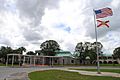
Top, left to right: Florida State Road 47 in Fort White, Fort White Train Depot, Fort White High School, Town of Fort White Historical Marker, Fort White Public School Historic District, Fort White United Methodist Church
|
|
| Motto(s):
"Home of the Ichetucknee River"
|
|

Location in Columbia County and the state of Florida
|
|
| Country | |
| State | |
| County | Columbia |
| Settled | 1836 |
| Incorporated | 1884 |
| Government | |
| • Type | Mayor-Council |
| Area | |
| • Total | 2.41 sq mi (6.25 km2) |
| • Land | 2.41 sq mi (6.25 km2) |
| • Water | 0.00 sq mi (0.00 km2) |
| Elevation | 69 ft (21 m) |
| Population
(2020)
|
|
| • Total | 618 |
| • Density | 256.01/sq mi (98.86/km2) |
| Time zone | UTC-5 (Eastern (EST)) |
| • Summer (DST) | UTC-4 (EDT) |
| ZIP code |
32038
|
| Area code(s) | 386 |
| FIPS code | 12-24500 |
| GNIS feature ID | 0282713 |
Fort White is a small town in Columbia County, Florida, USA. It is named after a military fort built there in the 1830s. The town is very close to the beautiful Ichetucknee Springs State Park. In 2020, about 618 people lived in Fort White. The town is also home to Fort White High School.
Contents
The Story of Fort White

How Fort White Began
Fort White started as a military fort in 1836. It was built during the Second Seminole War to protect a settlement called Cow Creek. Supplies for the fort came by steamboat on the Santa Fe River. These supplies were then sent to other forts nearby.
The first settlement faced problems like sickness and river floods. Also, people heard that a railroad was coming. So, the settlement moved about 4 miles (6.4 km) east to where the town is today.
Growth and Challenges
The Town of Fort White was officially created in 1884. It grew a lot after the railroad arrived in 1888. The town's economy was based on mining for Phosphate, making turpentine, and farming. People grew cotton and oranges. The population grew to almost 2,000 people.
However, things changed. Bad freezes in 1896 and 1897 destroyed the orange farms. By 1910, most of the phosphate was mined, so mining stopped. The boll weevil, a tiny bug, ruined cotton farming before World War I. The town's population then became much smaller, with only a few hundred people. Most residents were farmers, ranchers, and foresters. In 1979, only 365 people lived there.
Fort White's Location

Fort White is located in the southern part of Columbia County. You can find it where U.S. Route 27 and Florida State Road 47 meet.
- Florida State Road 47 goes north about 20 miles (32 km) to Lake City. Lake City is the main town in Columbia County.
- It also goes south about 23 miles (37 km) to Trenton.
- U.S. Route 27 goes southeast about 16 miles (26 km) to Alachua.
- It also goes west about 13 miles (21 km) to Branford.
The town covers about 2.4 square miles (6.2 square kilometers) of land. There is no water within the town's area. Most of the land around Fort White is used for family farms or forests.
The Amazing Ichetucknee River
The people living in Fort White have always known about the clear Ichetucknee River and its springs. These springs are about 4 miles (6.4 km) northwest of town. Before 1970, not many people knew about this natural wonder. The road to the springs was not paved or marked. This was because the springs were on private land.
In 1970, the state of Florida bought the Ichetucknee spring and river land. Columbia County then built a paved road, making it easier to reach the springs. In 1972, the main spring of the river was named a National Natural Landmark. This was done by the U.S. Department of the Interior.
The Ichetucknee River became a very popular place for tubing. Up to 5,000 visitors come each day during the summer. Other people visit the river to swim, have picnics, snorkel, or scuba dive. They also explore the nearby forests.
Weather in Fort White
Fort White has a humid subtropical climate. This means the summers are hot and humid. The winters are usually mild.
How Many People Live Here?
| Historical population | |||
|---|---|---|---|
| Census | Pop. | %± | |
| 1890 | 376 | — | |
| 1900 | 600 | 59.6% | |
| 1910 | 329 | −45.2% | |
| 1920 | 360 | 9.4% | |
| 1930 | 272 | −24.4% | |
| 1940 | 317 | 16.5% | |
| 1950 | 329 | 3.8% | |
| 1960 | 425 | 29.2% | |
| 1970 | 365 | −14.1% | |
| 1980 | 386 | 5.8% | |
| 1990 | 268 | −30.6% | |
| 2000 | 409 | 52.6% | |
| 2010 | 567 | 38.6% | |
| 2020 | 618 | 9.0% | |
| U.S. Decennial Census | |||
Population Changes (2010 and 2020)
| Race | Pop 2010 | Pop 2020 | % 2010 | % 2020 |
|---|---|---|---|---|
| White (NH) | 334 | 406 | 58.91% | 65.70% |
| Black or African American (NH) | 171 | 149 | 30.16% | 24.11% |
| Native American or Alaska Native (NH) | 4 | 2 | 0.71% | 0.32% |
| Asian (NH) | 3 | 5 | 0.53% | 0.81% |
| Pacific Islander or Native Hawaiian (NH) | 0 | 1 | 0.00% | 0.16% |
| Some other race (NH) | 1 | 2 | 0.18% | 0.32% |
| Two or more races/Multiracial (NH) | 12 | 12 | 2.12% | 1.94% |
| Hispanic or Latino (any race) | 42 | 41 | 7.41% | 6.63% |
| Total | 567 | 618 |
In 2020, the census counted 618 people living in Fort White. There were 214 households and 164 families.
In 2010, the census counted 567 people. There were 311 households and 169 families.
Schools in Fort White

The public schools in Fort White are part of the Columbia County School District.
- Fort White Elementary School
- Fort White Middle School
- Fort White High School
The first Fort White High School building was built in 1915. An auditorium was added in 1936. Separate classrooms for elementary school students were finished in 1938.
The last high school class graduated in 1969. Around that time, schools became integrated. This meant that schools for Black students in the area closed. There were not enough students to keep a high school in Fort White. So, students in grades 9-12 had to ride a bus 20 miles (32 km) to Columbia High School in Lake City. This continued for over 30 years.
After Ichetucknee Springs State Park opened in 1971, more people moved to the southern part of the county. This meant there was a need for a local high school again. A new high school costing $25 million was finished in December 2000. It opened in August 2000, using temporary buildings at first. The new Fort White High School graduated its first class in 2001. A new Fort White Middle School for grade 6 was finished before the 2008–2009 school year. The rest of the middle school (for grades 7 and 8) is also now finished and in use. The middle and high schools are still connected.
Images for kids
-
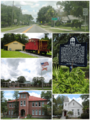
Top, left to right: Florida State Road 47 in Fort White, Fort White Train Depot, Fort White High School, Town of Fort White Historical Marker, Fort White Public School Historic District, Fort White United Methodist Church
-
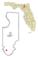
Location in Columbia County and the state of Florida
-
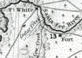
Excerpt from A Map of the Seat of War in Florida showing the fort location of Ft. White in 1839.
-
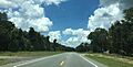
U.S. Route 27 in Fort White.
-
Fort White High School
See also
 In Spanish: Fort White para niños
