Echols County, Georgia facts for kids
Quick facts for kids
Echols County
|
||
|---|---|---|

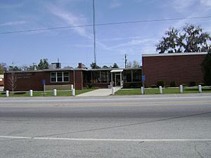
Echols County Courthouse in Statenville
|
||
|
||

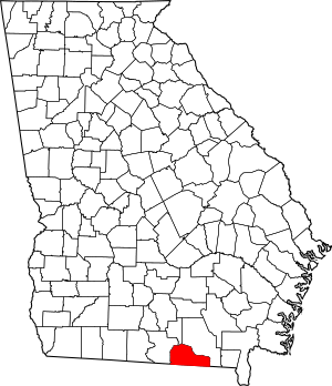
Location within the U.S. state of Georgia
|
||
 Georgia's location within the U.S. |
||
| Country | ||
| State | ||
| Founded | December 13, 1858 | |
| Named for | Robert Milner Echols | |
| Seat | Statenville | |
| Largest community | Statenville | |
| Area | ||
| • Total | 421 sq mi (1,090 km2) | |
| • Land | 415 sq mi (1,070 km2) | |
| • Water | 5.8 sq mi (15 km2) 1.4%% | |
| Population
(2020)
|
||
| • Total | 3,697 | |
| • Density | 9/sq mi (3/km2) | |
| Time zone | UTC−5 (Eastern) | |
| • Summer (DST) | UTC−4 (EDT) | |
| Congressional district | 1st | |
Echols County (pronounced EK-uhlz) is a county in the southeastern part of Georgia, a state in the United States. In 2020, about 3,697 people lived there. The main town and county center is Statenville.
Since 2008, Statenville is no longer an official city. Echols County and Webster County are the only two counties in Georgia without any official cities. Echols County was created in 1858. It was named after Robert Milner Echols, who lived from 1798 to 1847. Echols County is also part of the larger Valdosta metropolitan area.
Contents
History of Echols County
On December 13, 1858, the Georgia government officially created Echols County. It was formed from parts of Lowndes County and Clinch County. The county's first borders were set at that time. They mostly followed natural features like creeks and swamps.
Over the years, the borders have changed very little. There were only small adjustments with Lowndes County. Also, a thin strip of land was lost to Florida after a court case. Statenville was chosen as the county seat in 1859.
In 1860, about 1,491 people lived in Echols County. This included 1,177 white people and 314 enslaved people. There were no free people of color at that time.
Echols County became known for a unique reason. Sometimes, people in Georgia who committed certain acts were told to leave their home counties. The state's rules say they cannot be forced to leave Georgia. So, officials would ban them from 158 of Georgia's 159 counties. This left Echols County as their only option within the state. However, most people chose to leave Georgia instead of moving to Echols County.
Geography and Nature
Echols County covers about 421 square miles. Most of this area, about 415 square miles, is land. The rest, about 5.8 square miles, is water. A notable swamp called Whitehead Bay is located in the county.
The western part of Echols County is in the Alapaha River area. This river is part of the larger Suwannee River system. The eastern part of the county is in the Upper Suwannee River area.
Main Roads in Echols County
Important Waterways
- Alapaha River
- Alapahoochee River
- Grand Bay Creek
- Suwannee River
- Suwanoochee Creek
Railways in the County
- Georgia Southern and Florida Railway
- Seaboard Coast Line Railroad
- Plant System (now part of CSX)
- Statenville Railway (This railway is no longer used. It ran from Statenville to Haylow, Georgia, from 1910 to 1924.)
Neighboring Counties
- Clinch County – to the northeast
- Columbia County, Florida – to the southeast
- Hamilton County, Florida – to the south
- Lowndes County – to the west
- Lanier County – to the north
Small Communities in Echols County
These are small towns or areas that are not officially incorporated as cities:
- Fruitland
- Howell
- Needmore
- Statenville (the county seat)
Former Town
- Tarver (This town used to be called Statenville Station and Huckleberry.)
Population Information
| Historical population | |||
|---|---|---|---|
| Census | Pop. | %± | |
| 1860 | 1,491 | — | |
| 1870 | 1,978 | 32.7% | |
| 1880 | 2,553 | 29.1% | |
| 1890 | 3,079 | 20.6% | |
| 1900 | 3,209 | 4.2% | |
| 1910 | 3,309 | 3.1% | |
| 1920 | 3,313 | 0.1% | |
| 1930 | 2,744 | −17.2% | |
| 1940 | 2,964 | 8.0% | |
| 1950 | 2,494 | −15.9% | |
| 1960 | 1,876 | −24.8% | |
| 1970 | 1,924 | 2.6% | |
| 1980 | 2,297 | 19.4% | |
| 1990 | 2,334 | 1.6% | |
| 2000 | 3,754 | 60.8% | |
| 2010 | 4,034 | 7.5% | |
| 2020 | 3,697 | −8.4% | |
| 2023 (est.) | 3,709 | −8.1% | |
| U.S. Decennial Census 1790-1880 1890-1910 1920-1930 1930-1940 1940-1950 1960-1980 1980-2000 2010 2020 |
|||
This table shows the different groups of people living in Echols County. The US Census counts people by their race and whether they are of Hispanic or Latino background.
| Race / Ethnicity (NH = Non-Hispanic) | Pop 2000 | Pop 2010 | Pop 2020 | % 2000 | % 2010 | % 2020 |
|---|---|---|---|---|---|---|
| White alone (NH) | 2,688 | 2,555 | 2,328 | 71.60% | 63.34% | 62.97% |
| Black or African American alone (NH) | 252 | 163 | 147 | 6.71% | 4.04% | 3.98% |
| Native American or Alaska Native alone (NH) | 43 | 55 | 37 | 1.15% | 1.36% | 1.00% |
| Asian alone (NH) | 3 | 12 | 8 | 0.08% | 0.30% | 0.22% |
| Pacific Islander alone (NH) | 0 | 1 | 0 | 0.00% | 0.02% | 0.00% |
| Other race alone (NH) | 1 | 9 | 2 | 0.03% | 0.22% | 0.05% |
| Mixed race or Multiracial (NH) | 28 | 56 | 84 | 0.75% | 1.39% | 2.27% |
| Hispanic or Latino (any race) | 739 | 1,183 | 1,091 | 19.69% | 29.33% | 29.51% |
| Total | 3,754 | 4,034 | 3,697 | 100.00% | 100.00% | 100.00% |
As of the 2020 Census, there were 3,697 people living in Echols County. There were 1,561 households and 1,097 families.
Education in Echols County
The Echols County School District is the only school district in the county. It runs all the public schools for students in Echols County.
See also
 In Spanish: Condado de Echols para niños
 | Selma Burke |
 | Pauline Powell Burns |
 | Frederick J. Brown |
 | Robert Blackburn |


