Fruitland, Georgia facts for kids
Quick facts for kids
Fruitland, Georgia
|
|
|---|---|
| Country | United States |
| State | Georgia |
| County | Echols |
| Elevation | 161 ft (49 m) |
| Time zone | UTC-5 (Eastern (EST)) |
| • Summer (DST) | UTC-4 (EDT) |
| ZIP codes |
31630
|
| GNIS feature ID | 326295 |
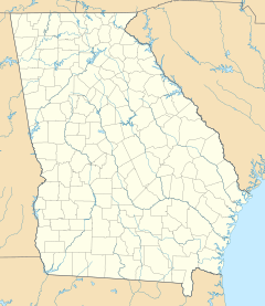
Fruitland is a small, quiet place in the state of Georgia, United States. It is not a city or a town with its own local government. Instead, it is known as an unincorporated community. Fruitland is found in the northeastern part of Echols County.
About Fruitland
Fruitland is located along State Route 187. This road helps connect Fruitland to other areas. It lies northeast of Statenville. Statenville is the main town in Echols County. It is where the county government offices are located.
What is an Unincorporated Community?
An unincorporated community is a group of homes or businesses. These places do not have their own local government. They do not have a mayor or a city council. Instead, they are usually governed by the larger county they are in. For Fruitland, this means Echols County manages services like roads and public safety.
Fruitland's Location and Height
Fruitland is in Echols County. This county is in the southern part of Georgia. The area is mostly rural, meaning it has a lot of open land and farms. Fruitland's elevation is 161 feet (about 49 meters). This means it is 161 feet above sea level. Knowing the elevation helps us understand the landscape.
 | Aurelia Browder |
 | Nannie Helen Burroughs |
 | Michelle Alexander |


