Webster County, Georgia facts for kids
Quick facts for kids
Webster County
|
|
|---|---|

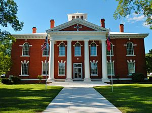
County courthouse in Preston
|
|

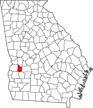
Location within the U.S. state of Georgia
|
|
 Georgia's location within the U.S. |
|
| Country | |
| State | |
| Founded | December 16, 1853 |
| Named for | Daniel Webster |
| Seat | Preston |
| Largest community | Preston |
| Area | |
| • Total | 210 sq mi (500 km2) |
| • Land | 209 sq mi (540 km2) |
| • Water | 1.1 sq mi (3 km2) 0.5%% |
| Population
(2020)
|
|
| • Total | 2,348 |
| • Density | 11/sq mi (4/km2) |
| Time zone | UTC−5 (Eastern) |
| • Summer (DST) | UTC−4 (EDT) |
| Congressional district | 2nd |
Webster County is a county in the west-central part of Georgia. In 2020, 2,348 people lived here. This makes it the third smallest county in Georgia by population. The main town, or county seat, is Preston.
Contents
History
Webster County was created on December 16, 1853. It was first called Kinchafoonee County. The Georgia General Assembly, which is Georgia's law-making group, made this happen.
Later, on February 21, 1856, its name was changed to Webster. The land for the county came from the eastern parts of Stewart County.
The county is named after Daniel Webster. He was a famous politician from New Hampshire and Massachusetts. He served in the U.S. House of Representatives and the U.S. Senate. The county's first name, Kinchafoonee, came from the Kinchafoonee Creek. This creek flows through the county.
On January 1, 2009, the towns of Preston and Weston joined together. They gave up their separate town governments. They formed a single government called the Unified Government of Webster County. This means the county and its main towns are run by one government.
Geography
Webster County covers about 210 square miles. Most of this area, about 209 square miles, is land. Only a small part, about 1.1 square miles, is water.
Most of Webster County is in the Kinchafoonee-Muckalee area. This area is part of a larger river system called the ACF River Basin. A small part of the county is in the Ichawaynochaway Creek area, which is also part of the ACF River Basin. A tiny edge of the county's southwest border is in the Middle Chattahoochee River-Walter F. George Lake area.
Major Highways
These are the main roads that go through Webster County:
Neighboring Counties
Webster County shares borders with these counties:
- Marion County – to the north
- Sumter County – to the east
- Terrell County – to the south
- Randolph County – to the southwest
- Stewart County – to the west
Communities
Webster County has a unified government. This means its communities are not separate cities or towns with their own governments.
People and Population
| Historical population | |||
|---|---|---|---|
| Census | Pop. | %± | |
| 1860 | 5,030 | — | |
| 1870 | 4,677 | −7.0% | |
| 1880 | 5,237 | 12.0% | |
| 1890 | 5,695 | 8.7% | |
| 1900 | 6,618 | 16.2% | |
| 1910 | 6,151 | −7.1% | |
| 1920 | 5,342 | −13.2% | |
| 1930 | 5,032 | −5.8% | |
| 1940 | 4,726 | −6.1% | |
| 1950 | 4,081 | −13.6% | |
| 1960 | 3,247 | −20.4% | |
| 1970 | 2,362 | −27.3% | |
| 1980 | 2,341 | −0.9% | |
| 1990 | 2,263 | −3.3% | |
| 2000 | 2,390 | 5.6% | |
| 2010 | 2,799 | 17.1% | |
| 2020 | 2,348 | −16.1% | |
| 2023 (est.) | 2,337 | −16.5% | |
| U.S. Decennial Census 1790-1880 1890-1910 1920-1930 1930-1940 1940-1950 1960-1980 1980-2000 2010 |
|||
The table below shows the different groups of people living in Webster County, based on the 2020 census.
| Race | Num. | Perc. |
|---|---|---|
| White | 1,136 | 48.38% |
| Black or African American | 1,063 | 45.27% |
| Asian | 12 | 0.51% |
| Pacific Islander | 6 | 0.26% |
| Other/Mixed | 72 | 3.07% |
| Hispanic or Latino | 59 | 2.51% |
In 2020, there were 2,348 people living in Webster County. There were 1,140 households and 724 families.
Education
The Webster County School District runs the public schools in the county.
See also
 In Spanish: Condado de Webster (Georgia) para niños
 | James Van Der Zee |
 | Alma Thomas |
 | Ellis Wilson |
 | Margaret Taylor-Burroughs |

