Stewart County, Georgia facts for kids
Quick facts for kids
Stewart County
|
|
|---|---|

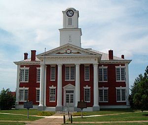
Stewart County courthouse in Lumpkin
|
|

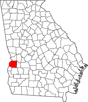
Location within the U.S. state of Georgia
|
|
 Georgia's location within the U.S. |
|
| Country | |
| State | |
| Founded | December 23, 1830 |
| Named for | Daniel Stewart |
| Seat | Lumpkin |
| Largest city | Richland |
| Area | |
| • Total | 464 sq mi (1,200 km2) |
| • Land | 459 sq mi (1,190 km2) |
| • Water | 4.9 sq mi (13 km2) 1.1%% |
| Population
(2020)
|
|
| • Total | 5,314 |
| • Density | 12/sq mi (5/km2) |
| Time zone | UTC−5 (Eastern) |
| • Summer (DST) | UTC−4 (EDT) |
| Congressional district | 2nd |
Stewart County is a county located in the west-central part of Georgia. In 2020, about 5,314 people lived here. The main town and county seat is Lumpkin. Stewart County was officially created on December 23, 1830.
Contents
History of Stewart County
For thousands of years before Europeans arrived, Native Americans lived in this area. The Roods Landing site is an important archaeological spot near Omaha. It has large earthwork mounds. These mounds were built around 1100–1350 CE by people of the advanced Mississippian culture. Another similar site is the Singer Moye Mounds, located in the southern part of the county.
In the mid-1500s, Spanish explorers were the first Europeans to meet these Native Americans. At that time, the Creek tribe lived in the southern two-thirds of what is now Georgia. They are thought to be descendants of the Mississippian culture.
The Creek people kept their land until more European American settlers arrived in the early 1800s. Conflicts grew, and many Creek people were forced to leave their homes. In the 1830s, the U.S. government made most Creek people move west of the Mississippi River. This forced movement is known as Indian removal. They were sent to Indian Territory, which is now Oklahoma.
Stewart County was formed on December 23, 1830. It was created from land that used to be part of Randolph County, Georgia. The county is named after Daniel Stewart. He was a hero of the American Revolutionary War and fought against Native Americans. He was also one of the great-grandfathers of U.S. president Theodore Roosevelt.
Settlers developed the area into large cotton plantations. This region was part of the "Black Belt" of Georgia. Before the American Civil War, plantation owners used enslaved African Americans to grow and process cotton. Many enslaved people were brought from the Upper South. Their families were often broken up when members were sold.
By 1850, Stewart County was very wealthy because it produced a lot of cotton. It had the tenth-largest population in Georgia, with 16,027 people. About 7,373 of them, or 46%, were enslaved African Americans.
By 1860, the county's population was 13,422. This drop happened because new counties, Webster County and Quitman County, were created from Stewart County's land in 1853 and 1858. In the newly defined Stewart County, there were 5,534 enslaved people. They made up more than one-third of the population.
After the Civil War and the Emancipation Proclamation, cotton remained the main crop. Many freedmen (formerly enslaved people) became sharecroppers or tenant farmers. The area remained agricultural but began to decline. Stewart County lost its important position because railroads were built to the north and south, bypassing it. The county didn't get railroad access until 1885.
Poor farming methods and too much cotton growing led to a lot of erosion by the early 1900s. Also, new machines for farming and damage from the boll weevil insect hurt the economy. The population started to decrease. Many African Americans left the area in two big waves, called the Great Migration. They sought to escape Jim Crow laws and find better jobs and lives in northern and midwestern cities. Farmers then started growing peanuts and later pine trees to help the land recover. The population continued to drop throughout the 1900s, as the forest and lumber industry didn't need as many workers.
In 1965, some towns in the county began to fix up their historic buildings. They wanted to attract tourists and help the economy grow. Lumpkin, Omaha, and Louvale had many old, well-preserved buildings. Green Grove is a historic African-American community started by freedmen after the Civil War. Stewart was the first rural county in Georgia to use historic preservation and Main Street projects to support heritage tourism.
Geography
Stewart County covers about 464 square miles. Of this, 459 square miles are land, and 4.9 square miles (1.1%) are water. The county is mostly in the upper Gulf Coastal Plain region of Georgia. It has some hills because it's close to the Atlantic Seaboard Fall Line.
Most of Stewart County is in the Middle Chattahoochee River-Walter F. George Lake area. This is part of the larger ACF River Basin (Apalachicola-Chattahoochee-Flint River Basin). Only the very eastern edge of the county, near Richland, is in the Kinchafoonee-Muckalee area of the same basin. The very southeastern corner is in the Ichawaynochaway Creek area.
Major highways
 U.S. Route 27
 U.S. Route 280
 State Route 1
 State Route 1 Connector
 State Route 27
 State Route 39
 State Route 39 Connector
 State Route 39 Spur
 State Route 520
Adjacent counties
- Chattahoochee County (north)
- Webster County (east)
- Randolph County (south)
- Quitman County (southwest)
- Barbour County, Alabama (west)
- Russell County, Alabama (northwest)
National protected area
Communities
Cities
Unincorporated communities
Population Data
| Historical population | |||
|---|---|---|---|
| Census | Pop. | %± | |
| 1840 | 12,933 | — | |
| 1850 | 16,027 | 23.9% | |
| 1860 | 13,422 | −16.3% | |
| 1870 | 14,204 | 5.8% | |
| 1880 | 13,998 | −1.5% | |
| 1890 | 15,682 | 12.0% | |
| 1900 | 15,856 | 1.1% | |
| 1910 | 13,437 | −15.3% | |
| 1920 | 12,089 | −10.0% | |
| 1930 | 11,114 | −8.1% | |
| 1940 | 10,603 | −4.6% | |
| 1950 | 9,194 | −13.3% | |
| 1960 | 7,371 | −19.8% | |
| 1970 | 6,511 | −11.7% | |
| 1980 | 5,896 | −9.4% | |
| 1990 | 5,654 | −4.1% | |
| 2000 | 5,252 | −7.1% | |
| 2010 | 6,058 | 15.3% | |
| 2020 | 5,314 | −12.3% | |
| 2023 (est.) | 4,674 | −22.8% | |
| U.S. Decennial Census 1790-1880 1890-1910 1920-1930 1930-1940 1940-1950 1960-1980 1980-2000 2010 |
|||
| Race / Ethnicity (NH = Non-Hispanic) | Pop 2010 | Pop 2020 | % 2010 | % 2020 |
|---|---|---|---|---|
| White alone (NH) | 1,655 | 1,338 | 27.32% | 25.18% |
| Black or African American alone (NH) | 2,833 | 2,461 | 46.76% | 46.31% |
| Native American or Alaska Native alone (NH) | 11 | 10 | 0.18% | 0.19% |
| Asian alone (NH) | 44 | 167 | 0.73% | 3.14% |
| Pacific Islander alone (NH) | 1 | 5 | 0.02% | 0.09% |
| Other race alone (NH) | 9 | 8 | 0.15% | 0.15% |
| Mixed race or Multiracial (NH) | 51 | 108 | 0.84% | 2.03% |
| Hispanic or Latino (any race) | 1,454 | 1,217 | 24.00% | 22.90% |
| Total | 6,058 | 5,314 | 100.00% | 100.00% |
In 2020, there were 5,314 people living in Stewart County. These people lived in 1,816 households, which included 1,138 families.
Parks and Recreation
Stewart County is home to two beautiful state parks: Florence Marina State Park and Providence Canyon State Park.
About 800 acres of the Eufaula National Wildlife Refuge are located along the eastern shores of the Chattahoochee River in Stewart County. This refuge helps protect wildlife. Also, the Hannahatchee Wildlife Management Area is a 5,600-acre preserve where people can hunt.
Images for kids
-
Boat Ramp at Florence Marina
See also
 In Spanish: Condado de Stewart (Georgia) para niños
 | Dorothy Vaughan |
 | Charles Henry Turner |
 | Hildrus Poindexter |
 | Henry Cecil McBay |


