
Omaha, Georgia facts for kids
Quick facts for kids
Omaha, Georgia
|
|
|---|---|
 |
|
| Country | United States |
| State | Georgia |
| Counties | Stewart |
| Area | |
| • Total | 184.9 sq mi (479 km2) |
| Population
(July 2007)
|
|
| • Total | 1,611 |
| • Density | 8.7/sq mi (3.4/km2) |
| Time zone | UTC-5 (Eastern (EST)) |
| • Summer (DST) | UTC-4 (EDT) |
| ZIP code |
31821
|
Omaha is a small community in Stewart County, Georgia, USA. It is an unincorporated community, meaning it does not have its own local government.
Contents
Local Businesses
Omaha has a local business called the Omaha Brewing Company. It is owned by Dr. Robert E. Lee, who grew up in Omaha, and his wife, Stephanie Lee.
Geography and Nature
Omaha is located in the northwest part of Stewart County. It is found where the Chattahoochee River meets Hannahatchee Creek.
Roads and Travel
Georgia State Route 39 is the main road that goes through Omaha. This road goes east about 12 kilometers (7.5 miles) to U.S. Route 27 near Louvale. It also goes south about 35 kilometers (22 miles) to Georgetown.
A road called Georgia State Route 39 Spur connects Omaha to the Alabama state line. This border is about 3 kilometers (2 miles) west, across the Chattahoochee River.
Nearby Natural Areas
The Fitzgerald Cemetery is located about a mile outside of Omaha. Florence Marina State Park is also found near Omaha. The Roods Landing site, an important historical area, is located south of the community.
History of Omaha
Omaha was founded in 1891. This happened when the railroad line reached the area.
Town Status and Change
The Georgia General Assembly officially made Omaha a town in 1891. However, the town's official government was ended in 1995.
Fort McCreary
Fort McCreary is located about one mile north of Omaha. It was built in 1836 to protect Georgia's border along the Chattahoochee River.
During the Creek War of 1836, US soldiers and Georgia volunteers were stationed there. They were led by a General McClesky. Soldiers from the fort helped Captain Hamilton Garmany's group of Georgia militia during a battle. This battle on the Shepherd Plantation was a major attack by the Creek people during the war.
Three unknown soldiers are buried at the fort. The Roanoke chapter of the Daughters of the American Revolution now owns the fort. In 1996, a wooden blockhouse, like those used long ago, was rebuilt at the site of Fort McCreary.
Omaha in Movies
A scene from the movie The Long Riders was filmed in Omaha. This scene, which took place in a cathouse, was shot in the Lee house. The Lee house was next to the Fitzgerald Cemetery. It was later torn down because it was in poor condition. The movie starred actors like Dennis and Randy Quaid, and Keith and David Carradine.
Gallery
-

Omaha Post Office (ZIP code: 31821)
-
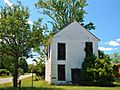
The Hiram Masonic Lodge dates back to the 1840s. The building has half-round log floor joints. A store was operated on the lower floor in the 1930s.
-
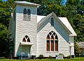
The Omaha Baptist Church was established in the late 1800s. The present building was constructed in 1914 following a tornado that destroyed much of the town including the original church building in 1913.
-
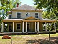
Walter E. Fitzgerald's original house was destroyed in the tornado of 1913. The current nineteen-room structure was built as a replacement in 1914.
-
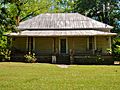
Mrs. Johnnie Brown House (c. 1850s)
-
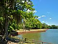
The Rood Creek Landing Recreation Area, just south of Omaha, is the location of the Roods Landing site, a Middle Woodland / Mississippian period Pre-Columbian complex of burial mounds.
-
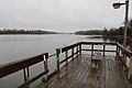
Florence Marina State Park is a 173-acre Georgia state park located near Omaha on the eastern shore of Walter F. George Lake. The park is known for its deep-water marina and its many water recreation sports, such as fishing and waterskiing.
.JPG)
_(Omaha,_GA).JPG)
_(Omaha,_GA).JPG)
_(Omaha,_GA).JPG)
.JPG)


