
Georgetown, Quitman County, Georgia facts for kids
Quick facts for kids
Georgetown
|
||
|---|---|---|
|
City
|
||

Georgetown in 2012.
|
||
|
||

Location in Quitman County and the state of Georgia
|
||
| Country | United States | |
| State | Georgia | |
| Counties | Quitman | |
| Area | ||
| • Total | 3.9 sq mi (10.2 km2) | |
| • Land | 2.7 sq mi (7.1 km2) | |
| • Water | 1.2 sq mi (3.1 km2) | |
| Population
(2020)
|
||
| • Total | 2,235 | |
| • Density | 573/sq mi (219.1/km2) | |
| ZIP code s |
39854
|
|
| Area code(s) | 229 | |

Georgetown is a city located in Quitman County, Georgia, in the United States. It sits right on the border between Alabama and Georgia, next to a big lake called Walter F. George Lake. The Chattahoochee River flows nearby, and across the river is the town of Eufaula, Alabama. In 2020, about 2,235 people lived there. In 2006, Georgetown and Quitman County decided to join their governments together. This made them the smallest combined city-county government in the main part of the United States.
Contents
History of Georgetown
Early Settlement and Name Change
Georgetown started as a settlement in the early 1830s. It was first called Tobanana, named after a nearby creek. The first post office opened there on January 10, 1833.
Later, on September 21, 1836, the town's name changed to Georgetown. It was named after a famous old neighborhood in Washington, D.C..
Becoming the County Seat
In 1859, Georgetown became the main town, or county seat, of Quitman County. The town was officially planned out by the local court. It officially became a town on December 9, 1859, through a law passed by the state government.
Civil War and a Big Fire
Towards the end of the American Civil War, a group of soldiers led by General Benjamin Grierson camped near Georgetown. They stayed by the Tobanana Creek for a while.
In 1903, a big fire destroyed almost all of Georgetown. Only the post office and three houses were left standing.
Geography of Georgetown
Size and Waterways
According to the United States Census Bureau, Georgetown covers about 3.9 square miles (10.2 square kilometers). Most of this area, about 2.7 square miles (7.1 square kilometers), is land. The rest, about 1.2 square miles (3.1 square kilometers), is water.
Main Roads and Connections
Several important roads run through Georgetown. These include U.S. Route 82 and Georgia State Routes 27 and 39.
U.S. Route 82 goes through the city as Middle Street. If you go west on this road, you'll reach Eufaula, Alabama in about 3 miles (5 km), crossing the Chattahoochee River. If you go southeast, you'll get to Cuthbert, Georgia in about 24 miles (39 km).
Georgia State Route 39 runs north and south through Georgetown. It leads north to Omaha, Georgia (about 22 miles or 35 km) and south to Fort Gaines, Georgia (about 23 miles or 37 km). Georgia State Route 27 starts in Georgetown and goes northeast to Lumpkin, Georgia, which is about 24 miles (39 km) away.
Population and People
How Many People Live Here?
| Historical population | |||
|---|---|---|---|
| Census | Pop. | %± | |
| 1870 | 263 | — | |
| 1880 | 245 | −6.8% | |
| 1890 | 348 | 42.0% | |
| 1900 | 348 | 0.0% | |
| 1910 | 313 | −10.1% | |
| 1920 | 244 | −22.0% | |
| 1930 | 345 | 41.4% | |
| 1940 | 367 | 6.4% | |
| 1950 | 550 | 49.9% | |
| 1960 | 554 | 0.7% | |
| 1970 | 860 | 55.2% | |
| 1980 | 935 | 8.7% | |
| 1990 | 913 | −2.4% | |
| 2000 | 973 | 6.6% | |
| 2010 | 2,513 | 158.3% | |
| 2020 | 2,235 | −11.1% | |
| U.S. Decennial Census 1850-1870 1870-1880 1890-1910 1920-1930 1940 1950 1960 1970 1980 1990 2000 2010 2020 |
|||
In 2000, there were 973 people living in Georgetown. By the 2020 census, the population was 2,235 people. This was a change from 2,513 people in 2010.
Diversity in Georgetown
The table below shows the different racial and ethnic groups living in Georgetown. The U.S. Census counts Hispanic/Latino as a separate ethnic group, so they are not included in the racial categories.
| Race / Ethnicity (NH = Non-Hispanic) | Pop 2010 | Pop 2020 | % 2010 | % 2020 |
|---|---|---|---|---|
| White alone (NH) | 1,265 | 1,190 | 50.34% | 53.24% |
| Black or African American alone (NH) | 1,198 | 917 | 47.67% | 41.03% |
| Native American or Alaska Native alone (NH) | 3 | 13 | 0.12% | 0.58% |
| Asian alone (NH) | 2 | 12 | 0.08% | 0.54% |
| Pacific Islander alone (NH) | 0 | 0 | 0.00% | 0.00% |
| Some Other Race alone (NH) | 0 | 9 | 0.00% | 0.40% |
| Mixed Race or Multi-Racial (NH) | 11 | 63 | 0.44% | 2.82% |
| Hispanic or Latino (any race) | 34 | 31 | 1.35% | 1.39% |
| Total | 2,513 | 2,235 | 100.00% | 100.00% |
Education in Georgetown
Quitman County School District
The Quitman County School District serves students from pre-school all the way to twelfth grade. The district has one elementary-middle school and one high school.
The high school teaches students from ninth through twelfth grade. The district has 22 full-time teachers and teaches over 314 students.
High School History
Before Quitman County High School opened in 2009, students from the county went to Stewart-Quitman High School. That school is now called Stewart County High School.
Notable People from Georgetown
- Bryant T. Castellow (1876–1962) was born near Georgetown. He was a politician, an educator, and a lawyer.
- The Castellows are a country music trio.
- Gladys L. Catchings (1901–1992) was born in Georgetown. She was a nurse, a hospital administrator, and an educator.
Images for kids
-
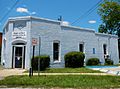
The Quitman County Courthouse was built in 1939. It was added to the National Register of Historic Places.
-
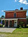
The old Quitman County Jail. It is also on the National Register of Historic Places.
-
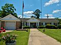
Georgetown City Hall.
-
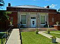
Georgetown Post Office (ZIP code: 39854)

.JPG)

.JPG)
See also
 In Spanish: Georgetown (condado de Quitman, Georgia) para niños
