
Lumpkin, Georgia facts for kids
Quick facts for kids
Lumpkin, Georgia
|
|
|---|---|

Stewart County Courthouse in Lumpkin
|
|

Location within Stewart County and Georgia
|
|
| Country | United States |
| State | Georgia |
| County | Stewart |
| Area | |
| • Total | 1.60 sq mi (4.14 km2) |
| • Land | 1.58 sq mi (4.10 km2) |
| • Water | 0.02 sq mi (0.04 km2) |
| Elevation | 600 ft (183 m) |
| Population
(2020)
|
|
| • Total | 891 |
| • Density | 563.21/sq mi (217.50/km2) |
| Time zone | UTC-5 (Eastern (EST)) |
| • Summer (DST) | UTC-4 (EDT) |
| ZIP code |
31815
|
| Area code(s) | 229 |
| FIPS code | 13-47980 |
| GNIS feature ID | 0317484 |
Lumpkin is a city in Stewart County, Georgia, United States. It's also the main town, or county seat, of Stewart County. In 2020, about 891 people lived there.
Contents
Exploring Lumpkin's Past
This part of Georgia was home to different groups of Native Americans for thousands of years. Tribes like the Cherokee, Choctaw, and Creek lived here. Later, European Americans moved into their lands.
Early Settlement and Naming
Lumpkin was officially made a town by European Americans on March 30, 1829. It was first named the county seat of Randolph County in December 1830. Just three weeks later, it became the seat of Stewart County when that county was created.
The city was named after Wilson Lumpkin. He was a two-time governor of Georgia and a lawmaker. He supported the idea of moving Native American tribes to lands west of the Mississippi River. There is another place named after him, Lumpkin County, which is in the northern part of Georgia.
Growth and Farming in Lumpkin
Lumpkin grew into an important trading center. Stagecoaches brought people and goods, and local merchants traded with nearby farmers. This area was known for its rich soil, perfect for growing cotton.
In the 1800s, many large cotton farms, called plantations, used the hard work of hundreds of thousands of enslaved African Americans. These people were forced to work without pay to grow and prepare the cotton for sale.
Changes After the Civil War
After the Civil War, many formerly enslaved people stayed in the area. They often worked as sharecroppers or tenant farmers, meaning they farmed land they didn't own and shared their crops with the landowner. The economy still relied on farming.
Over time, the soil became less fertile, and cotton farming decreased. Farmers started growing peanuts and pine trees instead. This meant fewer workers were needed. Many African Americans moved to cities in the North and Midwest for factory jobs. This movement is known as the Great Migration. Even with these changes, Lumpkin remained a fairly stable town, and the county is still mostly rural.
Preserving History in Lumpkin
Lumpkin was a leader in historic preservation for small towns in Georgia. They worked to save old buildings to attract visitors interested in history. This is called heritage tourism.
One important project was restoring the Bedingfield Inn. It was built in 1836 and is located in the town square. This inn is now listed on the National Register of Historic Places, which means it's a special historical site.
A Strong Tornado Hits Lumpkin
On December 5, 1954, a powerful F2 tornado struck the northwest side of Lumpkin. Sadly, one person died, and 20 people were hurt.
Westville: A Living History Village
In the 1960s, some local citizens created a special place called Westville. It was a living history village where you could see what life was like in western Georgia in the 1850s. They moved 30 historic buildings to create this village.
Volunteers worked there to show how people lived their daily lives. Westville has since moved to Columbus, Georgia.
Stewart Detention Center
Near Lumpkin, there is a private facility called the Stewart Detention Center. It houses people who are being held by the U.S. Immigration and Customs Enforcement. This center is run by a company called CoreCivic. In 2011, it was one of the largest and busiest facilities of its kind in the United States.
The city's population count in the 2020 census changed because the detention center was no longer included in Lumpkin's city limits. This is why the population number went down.
Lumpkin's Location and Size
Lumpkin is located at 32°02′59″N 84°47′45″W / 32.049638°N 84.795859°W. U.S. Route 27 runs just west of the city. This road goes north about 37 miles (60 km) to Columbus and south about 132 miles (212 km) to Tallahassee, Florida.
Georgia State Route 27 also goes through Lumpkin. It leads southwest about 24 miles (39 km) to Georgetown near the Alabama border. Going east, it leads about 9 miles (14 km) to Richland.
The United States Census Bureau says that Lumpkin covers a total area of about 1.6 square miles (4.1 km2). Most of this area is land, with a small amount of water.
Population Changes Over Time
| Historical population | |||
|---|---|---|---|
| Census | Pop. | %± | |
| 1860 | 765 | — | |
| 1870 | 778 | 1.7% | |
| 1880 | 747 | −4.0% | |
| 1900 | 1,470 | — | |
| 1910 | 1,140 | −22.4% | |
| 1920 | 934 | −18.1% | |
| 1930 | 1,103 | 18.1% | |
| 1940 | 1,210 | 9.7% | |
| 1950 | 1,209 | −0.1% | |
| 1960 | 1,348 | 11.5% | |
| 1970 | 1,431 | 6.2% | |
| 1980 | 1,335 | −6.7% | |
| 1990 | 1,250 | −6.4% | |
| 2000 | 1,369 | 9.5% | |
| 2010 | 2,741 | 100.2% | |
| 2020 | 891 | −67.5% | |
| U.S. Decennial Census 1850-1870 1870-1880 1890-1910 1920-1930 1940 1950 1960 1970 1980 1990 2000 2010 2020 |
|||
In the year 2000, there were 1,369 people living in Lumpkin. By 2020, the population had gone down to 891 people.
| Race / Ethnicity (NH = Non-Hispanic) | Pop 2010 | Pop 2020 | % 2010 | % 2020 |
|---|---|---|---|---|
| White alone (NH) | 396 | 246 | 14.45% | 27.61% |
| Black or African American alone (NH) | 893 | 599 | 32.58% | 67.23% |
| Native American or Alaska Native alone (NH) | 5 | 6 | 0.18% | 0.67% |
| Asian alone (NH) | 28 | 0 | 1.02% | 0.00% |
| Pacific Islander alone (NH) | 0 | 1 | 0.00% | 0.11% |
| Some Other Race alone (NH) | 9 | 3 | 0.33% | 0.34% |
| Mixed Race or Multi-Racial (NH) | 10 | 20 | 0.36% | 2.24% |
| Hispanic or Latino (any race) | 1,400 | 16 | 51.08% | 1.80% |
| Total | 2,741 | 891 | 100.00% | 100.00% |
Schools in Lumpkin
The Stewart County School District is in charge of education in Lumpkin. It includes schools from pre-school all the way to twelfth grade.
The district has:
- Stewart County Elementary School
- Stewart County Middle School
- Stewart County High School
There are 58 full-time teachers in the district, teaching over 704 students.
Famous People from Lumpkin
Lumpkin is the birthplace of a few notable people:
- Jarvis Jones: A retired NFL Linebacker who played for the Pittsburgh Steelers.
- John Wellborn Root: An American architect who was important in the Chicago School of design.
- Dorothy Pitman Hughes: An American feminist and civil rights activist.
Images for kids
-
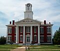
Stewart County Courthouse in Lumpkin
-
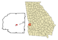
Location within Stewart County and Georgia
See also
 In Spanish: Lumpkin para niños
