
Weston, Georgia facts for kids
Quick facts for kids
Weston, Georgia
|
|
|---|---|

Weston
|
|

Location in Webster County and the state of Georgia
|
|
| Country | United States |
| State | Georgia |
| County | Webster |
| Area | |
| • Total | 0.9 sq mi (2.4 km2) |
| • Land | 0.9 sq mi (2.4 km2) |
| • Water | 0 sq mi (0 km2) |
| Elevation | 509 ft (155 m) |
| Population
(2000)
|
|
| • Total | 75 |
| • Density | 83.3/sq mi (31.3/km2) |
| Time zone | UTC-5 (Eastern (EST)) |
| • Summer (DST) | UTC-4 (EDT) |
| ZIP code |
31832
|
| Area code(s) | 229 |
| FIPS code | 13-82076 |
| GNIS feature ID | 0333396 |
Weston is a small place in Webster County, Georgia, in the United States. It's called an unincorporated community, which means it doesn't have its own local government like a city or town usually does. In 2000, about 75 people lived there.
In 2009, Weston stopped being an official town. It joined with the main government of Webster County instead.
Contents
History of Weston
Some people think Weston got its name from Joseph L. Weston, who was an important person in the early community. Others believe the name came from its location in the western part of the county.
Becoming and Un-Becoming a Town
The state government of Georgia, called the Georgia General Assembly, officially made Weston a town in 1911. This meant it had its own local rules and leaders.
However, in 2009, the town's official status was removed. This is called disincorporation. After that, Weston became part of the larger Webster County government.
Where is Weston Located?
Weston is found in the west-central part of Georgia. It is along Georgia State Route 520, also known as South Georgia Parkway. This road connects Weston to other towns.
Nearby Towns and Roads
If you go northwest on Route 520, you'll reach Richland in about 9 miles (15 km). If you go southeast, you'll get to Dawson in about 18 miles (29 km).
Weston is also roughly halfway between two bigger cities: Columbus (about 45 miles or 72 km northwest) and Albany (about 42 miles or 68 km southeast).
Another road, Georgia State Route 41, also goes through Weston. This road leads north about 8 miles (13 km) to Preston, which is the main town of Webster County. Going south on Route 41 for about 18 miles (29 km) will take you to Shellman.
Weston's Size
Weston covers an area of about 0.9 square miles (2.4 square kilometers). All of this area is land, with no water.
People Living in Weston
| Historical population | |||
|---|---|---|---|
| Census | Pop. | %± | |
| 1870 | 66 | — | |
| 1880 | 176 | 166.7% | |
| 1890 | 215 | 22.2% | |
| 1900 | 273 | 27.0% | |
| 1910 | 319 | 16.8% | |
| 1920 | 208 | −34.8% | |
| 1930 | 235 | 13.0% | |
| 1940 | 173 | −26.4% | |
| 1950 | 162 | −6.4% | |
| 1960 | 120 | −25.9% | |
| 1970 | 73 | −39.2% | |
| 1980 | 109 | 49.3% | |
| 1990 | 42 | −61.5% | |
| 2000 | 75 | 78.6% | |
| U.S. Decennial Census | |||
In the year 2000, there were 75 people living in Weston. These people lived in 29 different homes. Most of the people were White (81.33%) and some were African American (18.67%).
The average age of people living in Weston in 2000 was 47 years old.
Education in Weston
Students living in Weston attend public schools run by the Webster County School District.
Gallery
-
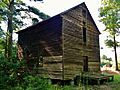
Boyd Mill Place was added to the National Register of Historic Places.
-
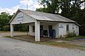
Weston Post Office (ZIP code: 31832)
-
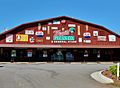
Merritt Pecan Company and General Store


See also
 In Spanish: Weston (Georgia) para niños
