
Duval County, Florida facts for kids
Quick facts for kids
Duval County
|
|||
|---|---|---|---|
|
Consolidated city-county
|
|||
| City of Jacksonville and Duval County | |||

Duval County Courthouse
|
|||
|
|||
| Nickname(s):
"Duuuval"
|
|||
| Motto(s):
"Duval Til We Die"
|
|||

Location within the U.S. state of Florida
|
|||
 Florida's location within the U.S. |
|||
| Country | |||
| State | |||
| Founded | August 12, 1822 | ||
| Named for | William Pope Duval | ||
| Seat | Jacksonville | ||
| Largest city | Jacksonville | ||
| Area | |||
| • Total | 918.464 sq mi (2,378.81 km2) | ||
| • Land | 762.623 sq mi (1,975.18 km2) | ||
| • Water | 155.841 sq mi (403.63 km2) 17.0%% | ||
| Population
(2020)
|
|||
| • Total | 995,567 | ||
| • Estimate
(2023)
|
1,030,822 |
||
| • Density | 1,975/sq mi (763/km2) | ||
| Time zone | UTC−5 (Eastern) | ||
| • Summer (DST) | UTC−4 (EDT) | ||
| Area code | 904 and 324 | ||
| Congressional districts | 4th, 5th | ||
| GDP Total $98.043 billion (2023) | |||


Duval County (pronounced "dew-VAWL") is a county in the northeastern part of Florida. It's officially known as the City of Jacksonville and Duval County. This is because the county government and the city of Jacksonville joined together in 1968. Jacksonville is also the county seat, which means it's where the main government offices are.
As of 2020, almost one million people live in Duval County. This makes it the sixth-most populated county in Florida. The county was created in 1822. It is named after William Pope Duval, who was the Governor of Florida Territory from 1822 to 1834. Duval County is the main county in the larger Jacksonville metropolitan area.
Contents
History of Duval County
People have lived in the Duval County area for thousands of years. These were different groups of indigenous peoples. In Jacksonville, within the Timucuan Ecological and Historic Preserve, scientists found some of the oldest pottery in the United States. It dates back to 2500 BCE!
Before Europeans arrived, the area was home to the Mocama people. They spoke a Timucuan language. The Mocama lived along the coast of northern Florida. In the 1500s, the Saturiwa tribe was very powerful in this region. The area that is now Duval County was once home to Fort Caroline, a French colony. Later, in the 1700s, more Europeans settled here. They started a place called Cowford, which was later renamed Jacksonville.
Duval County was officially created in 1822. It was formed from a part of St. Johns County. The county got its name from William Pope Duval. He was the Governor of Florida Territory from 1822 to 1834. When Duval County was first created, it was huge! It stretched from the Suwannee River in the west to the Atlantic Ocean in the east. Later, other counties like Alachua and Nassau were formed from parts of Duval County in 1824. Clay County was also created from Duval County in 1858.
-
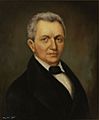
Portrait of William Pope Duval
-
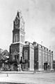
Duval County Courthouse in 1894
-

Jacksonville in 1909
-

Jacksonville Beach in 2018.


.jpeg)
Geography and Nature
Duval County covers about 918 square miles. About 762 square miles are land, and 155 square miles are water. This means about 17% of the county is water. The land is mostly a flat coastal plain. However, there are some gently rolling hills.
Protected Natural Areas
Duval County is home to important natural places. These areas help protect wildlife and history.
Neighboring Counties
Duval County shares borders with several other counties:
- Nassau County to the north and northwest
- St. Johns County to the southeast
- Clay County to the southwest
- Baker County to the west
People of Duval County
| Historical population | |||
|---|---|---|---|
| Census | Pop. | %± | |
| 1830 | 1,970 | — | |
| 1840 | 4,156 | 111.0% | |
| 1850 | 4,539 | 9.2% | |
| 1860 | 5,074 | 11.8% | |
| 1870 | 11,921 | 134.9% | |
| 1880 | 19,431 | 63.0% | |
| 1890 | 26,800 | 37.9% | |
| 1900 | 39,733 | 48.3% | |
| 1910 | 75,163 | 89.2% | |
| 1920 | 113,540 | 51.1% | |
| 1930 | 155,503 | 37.0% | |
| 1940 | 210,143 | 35.1% | |
| 1950 | 304,029 | 44.7% | |
| 1960 | 455,411 | 49.8% | |
| 1970 | 528,865 | 16.1% | |
| 1980 | 571,003 | 8.0% | |
| 1990 | 672,971 | 17.9% | |
| 2000 | 778,879 | 15.7% | |
| 2010 | 864,263 | 11.0% | |
| 2020 | 995,567 | 15.2% | |
| 2023 (est.) | 1,030,822 | 19.3% | |
| U.S. Decennial Census 1790–1960 1900–1990 1990–2000 2010–2020 |
|||
In early 2024, the average home value in Duval County was about $367,550.
There are over 428,000 households in Duval County. On average, about 2.36 people live in each home. The average household income is around $69,436 per year. About 14.6% of the people in the county live below the poverty line. Most adults in Duval County are employed (about 63.3%). Also, 91.6% of people have a high school diploma. About 34.3% have a bachelor's degree or higher. The average age of people in the county is 37.2 years old.
Population Details
As of the 2020 census, Duval County had 995,567 people. The population density was about 1,305 people per square mile. The county is diverse. About 51.7% of residents were White, and 29.4% were African American. About 11.3% of the population identified as Hispanic or Latino.
Many young people live in Duval County. About 22.3% of residents were under 18 years old. About 6.2% were under 5 years old. Around 15.7% of the population was 65 years or older. There are slightly more females (51.5%) than males (48.5%) in the county.
In 2010, about 9% of the county's population was born outside the United States. Many of these residents have become U.S. citizens. Most foreign-born residents came from Latin America or Asia.
Languages Spoken
Most people in Duval County speak English at home (about 87.4%). Other languages spoken include Spanish (5.7%), Tagalog (1.2%), Arabic (0.5%), and Vietnamese (0.47%). In total, about 12.6% of the population speaks a language other than English at home.
Education in Duval County

The public schools in Duval County are managed by Duval County Public Schools. The county also has a public library system called the Jacksonville Public Library.
Communities in Duval County
Duval County includes several cities and towns:
| Rank | Municipality | Type | 2023 Estimate | 2020 Census | Change |
|---|---|---|---|---|---|
| 1 | Jacksonville | City | 985,843 | 949,611 | +3.82% |
| 2 | Jacksonville Beach | City | 23,447 | 23,830 | −1.61% |
| 3 | Atlantic Beach | City | 13,182 | 13,513 | −2.45% |
| 4 | Neptune Beach | City | 6,984 | 7,217 | −3.23% |
| 5 | Baldwin | Town | 1,366 | 1,396 | −2.15% |
Transportation
Getting around Jacksonville and Duval County is made easy by several options.
Public Transportation
The Jacksonville Transportation Authority provides public transportation services. This includes buses and other ways to get around.
Major Roads
Many important highways run through Duval County, connecting it to other parts of Florida and the U.S.

 US 1 / SR 5
US 1 Alt.
 US 17 / SR 15
 US 23 / SR 139
 US 90
US 90
US 90 Alt.
 US 301 / SR 200
 SR A1A
 SR 9B
SR 9B SR 10
SR 10
Airports
Duval County has several airports, including a major international one:
- Cecil Airport
- Herlong Recreational Airport
- Jacksonville Executive at Craig Airport
- Jacksonville International Airport
See also
 In Spanish: Condado de Duval (Florida) para niños
