
Jacksonville Beach, Florida facts for kids
Quick facts for kids
Jacksonville Beach, Florida
|
|
|---|---|
|
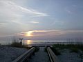
Pier at Jacksonville Beach in 2024
Jacksonville Beach view looking north
Jacksonville Beach City Hall
Seawalk Pavilion
Casa Marina Hotel
American Red Cross Volunteer Life Saving Corps Station
Jacksonville Beach view looking south
|
|

Location of Jacksonville Beach, Florida
|
|
| Country | United States |
| State | Florida |
| County | Duval |
| Settled | 1831 |
| Incorporated as Pablo Beach | May 22, 1907 |
| Incorporated as Jacksonville Beach | 1925 |
| Government | |
| • Type | Council–Manager |
| Area | |
| • City | 21.964 sq mi (56.886 km2) |
| • Land | 7.316 sq mi (18.948 km2) |
| • Water | 14.648 sq mi (37.939 km2) |
| Elevation | 10 ft (3 m) |
| Population
(2020)
|
|
| • City | 23,830 |
| • Estimate
(2023)
|
23,447 |
| • Density | 3,203.82/sq mi (1,237.01/km2) |
| • Urban | 1,247,374 |
| • Metro | 1,713,240 |
| Time zone | UTC−5 (Eastern (EST)) |
| • Summer (DST) | UTC−4 (EDT) |
| ZIP Codes |
32227, 32240, 32250
|
| Area code(s) | 904 and 324 |
| FIPS code | 12-35050 |
| GNIS feature ID | 0284697 |


Jacksonville Beach is a fun resort city located right on the coast in Duval County, Florida. In 2020, about 23,830 people lived here. It's part of a group of beach towns called the Jacksonville Beaches. These towns are on the northern part of San Pablo Island.
Other towns in this group include Mayport, Atlantic Beach, Neptune Beach, and Ponte Vedra Beach. In 1968, the city of Jacksonville joined with Duval County. But Jacksonville Beach, along with Atlantic Beach and Neptune Beach, voted to keep their own local governments. This means people in Jacksonville Beach can also vote for the mayor of Jacksonville. The city is part of the larger Jacksonville, Florida Metropolitan Statistical Area.
Contents
History of Jacksonville Beach
Jacksonville Beach became an official town on May 22, 1907. It was first called Pablo Beach. Later, in 1925, its name was changed to Jacksonville Beach.
Spanish settlers were the first Europeans to live in this area. They set up missions from Mayport all the way to St. Augustine. Spain gave Florida to Great Britain in 1763. Then Spain got it back, and finally, in 1821, it became part of the United States. American river pilots and fishermen came to a place called Hazard, which is now Mayport. They started a port there.
Pablo Beach: Early Days

In the late 1800s, people started to see that Duval County's oceanfront could be a great place for a resort. In 1883, a group of investors created the Jacksonville and Atlantic Railroad. They wanted to build a resort town that would be connected to Jacksonville by train.
The first settlers were William Edward Scull, an engineer, and his wife Eleanor Kennedy Scull. They lived in a tent near Pablo Historical Park. Another tent served as the general store and post office. Mrs. Scull became the postmaster in August 1884. Mail was sent by horse and buggy to Mayport, then by boat to Jacksonville.
The Sculls built the first house in 1884. They named the settlement Ruby after their first daughter. On May 13, 1886, the town was renamed Pablo Beach. This new name came from the San Pablo River.
In 1885, the San Pablo Diego Beach Land Co. sold town lots for $50 to $100 each. They also sold larger 5 to 10 acre lots for $10 to $20 per acre. These were all within 3 miles of the new seaside resort. In September 1892, work began on a road to Pablo Beach, which is now Atlantic Boulevard.
The first resort hotel, the Murray Hall Hotel, opened in mid-1886. But it was destroyed by a fire in August 1890. By 1900, the railway company faced money problems. Henry Flagler took over the railway as part of his Florida East Coast Railway. In late 1900, the railway was updated and extended to Mayport.
The Spanish–American War started in 1898. The 3rd Nebraska army group arrived in July 1898 for training. They set up camp at Pablo Beach. Their leader was William Jennings Bryan, who ran for president three times. After flooding at the Pablo Beach camp, the 3rd Nebraska moved to downtown Jacksonville.
Jacksonville Beach: A New Era

The fun park era of Jacksonville Beach began in 1905 with The Pavilion. It later grew and was called Little Coney Island. This was a popular place for tourists. It had a dance floor, a swimming area, a bowling alley, and roller skating rinks. Because it was made of wood and faced constant weather, Little Coney Island became old and was torn down in 1925.
On June 15, 1925, the name Pablo Beach officially changed to Jacksonville Beach. Shad's Pier was built in 1922 by Charles Shad and Martin Williams. Around the same time, W. H. Adams, Sr. opened the Ocean View Pavilion amusement park. This was on the old site of the Murray Hall Hotel. Adams wanted a roller coaster bigger than the one at Little Coney Island. He built a 93-foot-high coaster.
However, being so close to the beach, the coaster was easily damaged. It was eventually thought to be unsafe. The large coaster was then taken apart and made into a smaller one. This change hurt business at the park. By 1949, the Ocean View Pavilion was struggling. A few years later, a fire destroyed it. Today, the only amusement park in Jacksonville Beach is Adventure Landing. The boardwalk became less popular in the 1950s. This was because of stricter rules on gambling and games of chance. Driving cars on the beach was stopped in 1979.
Pablo Beach made aviation history on February 24, 1921. Lt. Wm. DeVoe Coney landed there after a flight across the country from San Diego, California. He completed the flight in 22 hours and 17 minutes, beating the old record. Coney's record was soon broken on September 5, 1922. Jimmy Doolittle flew a De Havilland DH-4 biplane from Pablo Beach to San Diego in 21 hours and 19 minutes.
In 1968, most people in Duval County voted to combine the county and the City of Jacksonville. But Jacksonville Beach, Atlantic Beach, Neptune Beach, and Baldwin voted to keep their own local governments. So, they are not part of the City of Jacksonville. However, they get county-level services from Jacksonville. They also vote for Jacksonville's mayor and City Council.
Judy Van Zant, the wife of Lynyrd Skynyrd lead singer Ronnie Van Zant, and her daughter Melody opened the Freebird Cafe in 1999. Freebird Live, as it was later called, was a very popular music spot. It was a key part of Jacksonville Beach for 16 years until it closed in 2016.
In September 1999, Hurricane Floyd destroyed the Jacksonville Beach Pier. Five years later, the pier was rebuilt. In October 2016, Hurricane Matthew caused a required evacuation for Jacksonville Beach. Hurricane Matthew passed 40 miles off the coast, causing major flooding. The Jacksonville Beach Pier was partly destroyed by Hurricane Matthew.
Geography of Jacksonville Beach
Jacksonville Beach is located at 30°17′40.87″N 81°23′35.30″W / 30.2946861°N 81.3931389°W.
The city covers a total area of about 21.964 square miles (56.886 square kilometers). Most of this area, about 14.648 square miles (37.939 square kilometers), is water. The land area is about 7.316 square miles (18.948 square kilometers).
Jacksonville Beach is the biggest town in the Jacksonville Beaches area. It is the eastern end of U.S. Route 90. This road finishes at an intersection with State Road A1A, just three blocks from the Atlantic Ocean.
City Views and Architecture

The buildings in Jacksonville Beach have many different styles. The Casa Marina Hotel is a good example. It was designed by Marsh and Saxelbye and finished in 1925. It has a Mission style, which was popular in the 1920s. This was when Jacksonville's beaches were being developed. The hotel was added to the National Register of Historic Places in 1993.
The American Red Cross Volunteer Life Saving Corps Station was built in 1947. It is an Art Moderne style lifeguard station. It was designed by local architect Jefferson Davis Powell. It was added to the National Register of Historic Places in 2014. Jacksonville Beach also has many buildings in the Mid-Century modern style. Some of the most famous were designed by architect William Morgan.
-
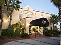
Casa Marina Hotel (1925)
-
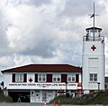
American Red Cross Volunteer Life Saving Corps Station (1947)
-
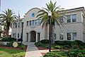
City Hall
-
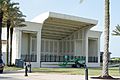
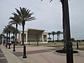
Seawalk Pavilion


Climate and Weather
Jacksonville Beach has a humid subtropical climate. This means it has hot, humid summers and mild winters.
| Climate data for Jacksonville Beach, Florida, 1991–2020 normals, extremes 1944–present | |||||||||||||
|---|---|---|---|---|---|---|---|---|---|---|---|---|---|
| Month | Jan | Feb | Mar | Apr | May | Jun | Jul | Aug | Sep | Oct | Nov | Dec | Year |
| Record high °F (°C) | 88 (31) |
90 (32) |
94 (34) |
94 (34) |
98 (37) |
102 (39) |
103 (39) |
102 (39) |
98 (37) |
95 (35) |
95 (35) |
85 (29) |
103 (39) |
| Mean maximum °F (°C) | 78.7 (25.9) |
81.0 (27.2) |
84.8 (29.3) |
87.7 (30.9) |
92.0 (33.3) |
94.2 (34.6) |
95.9 (35.5) |
94.9 (34.9) |
92.1 (33.4) |
87.8 (31.0) |
82.9 (28.3) |
79.6 (26.4) |
97.0 (36.1) |
| Mean daily maximum °F (°C) | 64.8 (18.2) |
67.6 (19.8) |
72.4 (22.4) |
77.3 (25.2) |
83.1 (28.4) |
87.0 (30.6) |
89.3 (31.8) |
88.6 (31.4) |
85.9 (29.9) |
80.4 (26.9) |
73.0 (22.8) |
67.2 (19.6) |
78.0 (25.6) |
| Daily mean °F (°C) | 57.1 (13.9) |
59.8 (15.4) |
64.6 (18.1) |
70.2 (21.2) |
76.6 (24.8) |
81.0 (27.2) |
82.9 (28.3) |
82.8 (28.2) |
80.8 (27.1) |
74.7 (23.7) |
66.3 (19.1) |
60.1 (15.6) |
71.4 (21.9) |
| Mean daily minimum °F (°C) | 49.3 (9.6) |
52.0 (11.1) |
56.9 (13.8) |
63.2 (17.3) |
70.1 (21.2) |
75.1 (23.9) |
76.6 (24.8) |
77.0 (25.0) |
75.6 (24.2) |
69.0 (20.6) |
59.7 (15.4) |
53.1 (11.7) |
64.8 (18.2) |
| Mean minimum °F (°C) | 29.9 (−1.2) |
33.9 (1.1) |
38.7 (3.7) |
47.5 (8.6) |
58.4 (14.7) |
68.6 (20.3) |
71.2 (21.8) |
71.4 (21.9) |
66.2 (19.0) |
51.7 (10.9) |
40.8 (4.9) |
35.2 (1.8) |
27.8 (−2.3) |
| Record low °F (°C) | 14 (−10) |
21 (−6) |
24 (−4) |
37 (3) |
46 (8) |
55 (13) |
63 (17) |
63 (17) |
53 (12) |
36 (2) |
25 (−4) |
15 (−9) |
14 (−10) |
| Average precipitation inches (mm) | 3.50 (89) |
2.82 (72) |
3.21 (82) |
3.01 (76) |
2.93 (74) |
6.79 (172) |
4.90 (124) |
7.54 (192) |
7.19 (183) |
5.10 (130) |
2.50 (64) |
2.95 (75) |
52.44 (1,332) |
| Average precipitation days (≥ 0.01 in) | 10.2 | 9.2 | 8.0 | 7.0 | 7.6 | 12.7 | 12.7 | 14.3 | 13.1 | 9.5 | 8.3 | 9.3 | 121.9 |
| Source: NOAA | |||||||||||||
Parks and Fun Places
Hanna Park is a public beach and city park about 1.5 miles (2.4 km) long. It's located near Mayport in the Jacksonville Beaches area. The park has 447 acres (1.81 km2) of old coastal forests called hammocks. It used to be known as Manhattan Beach. This was Florida's first beach community for African Americans during the time of segregation in the United States.
-
Beach access point
-
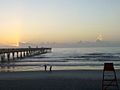
Jacksonville Beach Pier
-
Sea Walk Pavilion


People and Population
| Historical population | |||
|---|---|---|---|
| Census | Pop. | %± | |
| 1910 | 249 | — | |
| 1920 | 357 | 43.4% | |
| 1930 | 409 | 14.6% | |
| 1940 | 3,566 | 771.9% | |
| 1950 | 6,430 | 80.3% | |
| 1960 | 12,049 | 87.4% | |
| 1970 | 12,779 | 6.1% | |
| 1980 | 15,462 | 21.0% | |
| 1990 | 17,839 | 15.4% | |
| 2000 | 20,990 | 17.7% | |
| 2010 | 21,362 | 1.8% | |
| 2020 | 23,830 | 11.6% | |
| 2023 (est.) | 23,447 | 9.8% | |
| U.S. Decennial Census 2020 Census |
|||
In 2023, there were about 10,837 homes in Jacksonville Beach. Each home had about 2.16 people on average. The average income for a household in the city was $115,825. About 5.8% of the people in the city lived at or below the poverty line.
About 73.8% of the people in Jacksonville Beach have jobs. Also, 58.2% of the people have a bachelor's degree or higher. A large number, 96.9%, have a high school diploma.
The most common backgrounds people reported were English (93.4%), Spanish (2.5%), and Indo-European (3.1%). The average age in the city was 44.0 years old.
Population Details from 2020
As of the 2020 census, Jacksonville Beach had 23,830 people living there. There were 11,351 households and 6,031 families.
The population density was about 3256.4 people per square mile (1257.3 per square kilometer). There were 12,789 housing units.
Here's a look at the different groups of people in the city:
- 86.68% White
- 2.85% African American
- 0.25% Native American
- 1.98% Asian
- 0.03% Pacific Islander
- 1.36% from some other races
- 6.86% from two or more races
People who are Hispanic or Latino (of any race) made up 5.53% of the population.
About 17.7% of residents were under 18 years old. About 3.1% were under 5 years old. And 20.3% were 65 years or older. The city had slightly more males (51.7%) than females (48.3%).
Getting Around Jacksonville Beach
Beach Boulevard (US 90) connects Jacksonville Beach to the Southside area of Jacksonville. It continues west to downtown Jacksonville. This is done through the Commodore Point Expressway and Hart Bridge.
Butler Boulevard (SR 202) starts in southeast Jacksonville at Philips Highway (US 1). It ends in southern Jacksonville Beach at 3rd Street South (SR A1A). SR A1A is a popular road with great ocean views. It stretches from Fernandina Beach to Key West. In Jacksonville Beach, it is the main road for businesses. It runs along the entire beachside community.
Main Roads
 US 90
US 90 SR A1A
 SR 202
Schools in Jacksonville Beach

The Duval County Public Schools district runs the public schools in Jacksonville Beach. These include:
- San Pablo Elementary School
- Jacksonville Beach Elementary
- Seabreeze Elementary
- Fletcher Middle School
Famous People from Jacksonville Beach
- Jonas Blixt (born 1984), a professional golfer
- Ben Cooper (born 1982), a musician
- Matt Every (born 1983), a professional golfer
- Billy Horschel (born 1986), a professional golfer
- David Lingmerth (born 1987), a professional golfer
- Donna Orender (born 1957), a sports executive and former basketball player
- Jimmy Plumer, a professional skateboarder
- Francis E. Spinner (1802–1890), who was the Treasurer of the United States during the Civil War
- Tim Tebow (born 1987), a professional baseball player and former professional football player
See also
 In Spanish: Jacksonville Beach para niños
