Hurricane Matthew facts for kids
Hurricane Matthew was a very powerful Atlantic hurricane that formed in September 2016. It became the first Category 5 hurricane in the Atlantic Ocean since Hurricane Felix in 2007. This means its winds were incredibly strong, reaching up to 160 miles per hour!
Matthew caused a lot of damage and sadness across many countries. It threatened places like Jamaica, Cuba, the Dominican Republic, and the Bahamas. On October 4, 2016, Hurricane Matthew made landfall in Haiti, and then hit Cuba later that same day.
Forecasters thought Matthew might hit the Southeastern United States, including states like Florida and North Carolina. They also thought it might reach New England, but later predictions showed it would not go that far north.
This hurricane caused many deaths, especially in Hispaniola (the island shared by Haiti and the Dominican Republic) and other parts of the Caribbean. In the United States, 49 people died because of the storm. The damage in Haiti alone was estimated to be over $1 billion.
Contents
How Hurricane Matthew Formed and Grew
Hurricane Matthew started as a tropical wave, which is like a ripple in the atmosphere. It formed near the Windward Islands in the Atlantic Ocean on September 28, 2016. As it moved west, it quickly gathered strength and became a tropical storm, then a hurricane.
Matthew Becomes a Major Hurricane
Matthew kept getting stronger as it moved through the Caribbean Sea. On September 30, it became a major hurricane, meaning it was a Category 3 or higher. Its winds were very powerful, and it was heading towards the Greater Antilles.
Reaching Category 5 Strength
On October 1, Hurricane Matthew reached its peak strength. It became a Category 5 hurricane, with winds of 160 miles per hour. This made it an extremely dangerous storm, the strongest in the Atlantic in nine years.
Where Hurricane Matthew Traveled
Hurricane Matthew followed a path that brought it close to many islands and parts of the United States.
Impact on the Caribbean
Matthew first moved through the Caribbean, bringing heavy rain and strong winds to several islands.
- Haiti: The storm hit Haiti directly as a powerful Category 4 hurricane on October 4. This caused massive damage, especially in the southern parts of the country. Many homes were destroyed, and roads were blocked by floods and fallen trees.
- Cuba: After Haiti, Matthew moved towards Cuba, hitting the eastern tip of the island. While Cuba has strong building codes, the storm still caused significant damage to homes and infrastructure.
- Other Islands: Jamaica, the Dominican Republic, and the Bahamas also felt the effects of Matthew, with strong winds, heavy rainfall, and storm surges.
Threat to the United States
After passing through the Caribbean, Hurricane Matthew moved north, heading towards the southeastern coast of the United States.
- Florida: Matthew moved very close to Florida's coast, causing strong winds, heavy rain, and dangerous storm surges. Many people had to leave their homes and move to safer areas.
- Georgia and South Carolina: The hurricane continued up the coast, bringing flooding and power outages to parts of Georgia and South Carolina.
- North Carolina and Virginia: Even after weakening, Matthew still caused severe flooding in eastern North Carolina and parts of Virginia. Rivers overflowed their banks, leading to widespread damage days after the storm passed.
The Impact and Damage Caused by Matthew
Hurricane Matthew was one of the deadliest and most damaging hurricanes in recent history.
Loss of Life
The storm caused a tragic loss of life.
- Over 1,600 people died in Hispaniola and the Caribbean, with the majority of deaths occurring in Haiti.
- In the United States, 49 people died due to the hurricane.
- The Dominican Republic reported four deaths.
Economic Damage
The financial cost of Hurricane Matthew was enormous.
- In Haiti, the damage was estimated to be over $1 billion. This was a huge setback for a country that was already facing many challenges.
- In the United States, the total damage was estimated to be around $10 billion. This included damage to homes, businesses, roads, and other important structures.
Flooding and Erosion
One of the biggest problems caused by Matthew was widespread flooding.
- Heavy rains led to rivers overflowing, especially in North Carolina.
- The strong waves and storm surge caused erosion along coastlines, washing away beaches and damaging cliffs.
How People Responded to Hurricane Matthew
Many organizations and people worked together to help those affected by Hurricane Matthew.
Evacuations and Warnings
Before the storm hit, weather experts issued warnings, and governments told people to leave dangerous areas. This helped save many lives, especially in the United States.
Rescue and Relief Efforts
After the hurricane, rescue teams, including the North Carolina National Guard, helped people trapped by floods. Organizations provided food, water, and medical help to those who had lost everything. Helicopters, like the CH-53E Sea Stallion, were used to deliver supplies and transport people.
Images for kids
-
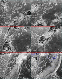
Water vapour loop of Matthew passing over the Windward Islands and entering the Caribbean Sea on September 28
-
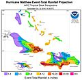
A map of forecast rainfall totals from Hurricane Matthew for the Greater Antilles and the Bahamas. Peak accumulations in excess of 30 in (760 mm) were expected along the southern coast of Haiti's Tiburon Peninsula.
-
Enhanced infrared satellite loop of Matthew passing east of Florida on October 7
-
View of cliff erosion a day after Hurricane Matthew hit Naval Station Guantanamo Bay
-
Flooding in Charleston, South Carolina on October 8.
-
The Tar River overflowing its banks near Pitt–Greenville Airport on October 12; it later crested at 24.5 feet (7.5 m).
-
Heavy rains and high winds resulted in trees falling and record flooding in Lago Mar, Virginia Beach, Virginia.
-
North Carolina National Guard assisting with high-water rescues in Fayetteville, North Carolina
See also
 In Spanish: Huracán Matthew para niños
 | Mary Eliza Mahoney |
 | Susie King Taylor |
 | Ida Gray |
 | Eliza Ann Grier |


