Tar River facts for kids
Quick facts for kids Tar River |
|
|---|---|

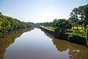
The Tar River flowing next to East Carolina University in Greenville, North Carolina
|
|

|
|
| Country | United States |
| State | North Carolina |
| Region | South |
| Cities | Louisburg, North Carolina, Rocky Mount, North Carolina, Tarboro, North Carolina, Greenville, North Carolina, Washington, North Carolina |
| Physical characteristics | |
| Main source | a freshwater spring Person County, North Carolina, United States 715 ft (218 m) 36°24′54″N 78°49′15″W / 36.41500°N 78.82083°W |
| River mouth | Pamlico Sound (as the Pamlico River) Lowland, North Carolina, United States −13 ft (−4.0 m) 35°20′08″N 76°28′20″W / 35.33556°N 76.47222°W |
| Length | 346 km (215 mi) |
| Basin features | |
| Basin size | 15,920 km2 (6,150 sq mi) |
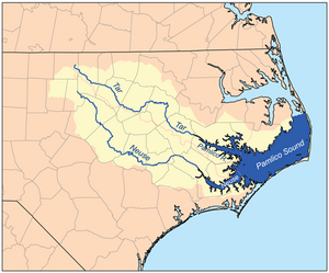
The Tar River is a fascinating river in northeastern North Carolina, United States. It flows for about 346 kilometers (215 miles) generally southeast, eventually reaching the Pamlico Sound. As it gets closer to the ocean, near Washington, North Carolina, it changes its name to the Pamlico River and becomes a tidal estuary, meaning its water levels are affected by the ocean's tides.
Contents
Why is it Called the Tar River?
The Tar River got its unique name from its important role in history. Long ago, North Carolina was known for its vast forests of longleaf pine trees. These trees were a valuable resource. People would collect sticky pine resin, called "pine pitch," from the trees. This pitch was then used to make tar, which was essential for sealing ships and making them waterproof.
The Tar River served as a busy highway for barges loaded with this tar. These barges traveled down the river towards the sea, carrying their important cargo. This historical use as a major route for tar transportation is how the river earned its name. The city of Tarboro, located right on the riverbanks, also shares this historical connection in its name.
Before the American Civil War, people even tried to make the river easier to navigate. The North Carolina government provided money to build dams and locks. These structures helped boats carry farm products, naval supplies, and even passengers between towns like Tarboro, Greenville, and Washington almost all year round.
A Story About the River's Name
There's a famous story from the American Civil War that helps explain the river's name. In March 1862, during the war, soldiers from the Confederate side were leaving Washington, North Carolina. To prevent valuable supplies from falling into the hands of the Union soldiers, they destroyed many goods. At one store, they found over a thousand barrels of turpentine and tar. Since burning them would have been too dangerous, they rolled the barrels into the river and emptied their contents.
A few months later, in June, Union soldiers who were prisoners of war were being exchanged. They were traveling to Washington, North Carolina, and asked to bathe in the river to clean up. As they waded into the water, they stirred up the river bottom. To their surprise, the river was still full of tar! It coated their bodies, and they had to use sticks to scrape it off. One soldier reportedly exclaimed that they had finally found the "Tar River" for real, because the riverbed itself seemed to be made of tar. This event further cemented the river's unique name in local history.
Exploring Towns Along the Tar River
Many towns and cities have grown up along the banks of the Tar River. As you travel along its course, you would find places like Louisburg, Rocky Mount, Tarboro, and Greenville. These communities have historically relied on the river for transportation, trade, and daily life. The village of Old Sparta was once a very important riverport, a place where boats would load and unload goods, but its importance lessened over time.
The Tar River and Major Storms
The Tar River has experienced significant flooding from powerful storms. In 1999, Hurricane Floyd caused severe damage and widespread flooding in the area. The Tar River was hit especially hard, with water levels reaching heights not seen in over 500 years in some parts. In Greenville, the river crested at an astonishing 9.1 meters (29.74 feet) above its normal flood stage.
More recently, in 2016, Hurricane Matthew also impacted the river. It caused the Tar River to rise as much as 7.5 meters (24.5 feet) above flood stage in certain areas, and the high water levels lasted for up to three days. These events show how powerful nature can be and how rivers can change dramatically during extreme weather.
Unique Wildlife: The Tar River Spinymussel
The Tar River is home to special wildlife, including an endangered species called the Tar River Spinymussel. This unique freshwater mussel is found in only a few specific locations within the Tar and Neuse River basins. Protecting these mussels and their habitat is very important for keeping the river's ecosystem healthy.
Protecting the Tar River's Future
Organizations like Sound Rivers are dedicated to keeping the Tar and Neuse River watersheds clean and healthy. A watershed is the area of land where all the water drains into a particular river or lake. Sound Rivers works to protect these important natural areas. They also help people enjoy the river by maintaining fifteen camping platforms and campsites along the Tar-Pamlico Water Trail, which is a great way to explore the river's beauty.
 | Delilah Pierce |
 | Gordon Parks |
 | Augusta Savage |
 | Charles Ethan Porter |

