
Tarboro, North Carolina facts for kids
Quick facts for kids
Tarboro, North Carolina
|
||
|---|---|---|

Main Street, downtown
|
||
|
||
| Nickname(s):
T-Town
|
||

Location in Edgecombe County and the state of North Carolina.
|
||
| Country | ||
| State | ||
| County | Edgecombe | |
| Founded | 1760 | |
| Incorporated | 1772 | |
| Named for | Tar River | |
| Government | ||
| • Type | Council–Manager | |
| Area | ||
| • Total | 11.31 sq mi (29.29 km2) | |
| • Land | 11.27 sq mi (29.19 km2) | |
| • Water | 0.04 sq mi (0.10 km2) | |
| Elevation | 62 ft (19 m) | |
| Population
(2020)
|
||
| • Total | 10,721 | |
| • Density | 951.12/sq mi (367.22/km2) | |
| Time zone | UTC−5 (Eastern (EST)) | |
| • Summer (DST) | UTC−4 (EDT) | |
| ZIP code |
27886
|
|
| Area code(s) | 252 | |
| FIPS code | 37-66700 | |
| GNIS feature ID | 2406714 | |

Tarboro is a town in Edgecombe County, North Carolina, United States. It is part of the Rocky Mount area. In 2020, about 10,721 people lived there. Tarboro is the main town, or county seat, of Edgecombe County. It sits on the Tar River, across from the town of Princeville. Tarboro is located near the western edge of North Carolina's coastal plain. The town has many old churches, some built as early as 1742.
British colonists officially started Tarboro in 1760. It was an important river port because it was at the end of the Tar River where boats could travel. A small community grew here in the 1730s. By the late 1700s, it was a busy village with businesses, a church, a jail, and homes.
Contents
Discovering Tarboro's Past
Tarboro is the ninth-oldest town in North Carolina. It was created in 1760. The town was a key river port on the Tar River. It was a busy trading center until the American Civil War.
Experts believe people lived around Tarboro by 1733. However, maps from that time only show Tuscarora Native Americans. By 1750, the area was known as "Tawboro." This name came from Taw, a Tuscaroran word meaning "river of health."
The town was called "Tarrburg" on maps from 1770–75. It was officially named "Tarborough" on November 30, 1760. Joseph and Ester Howell sold 150 acres of their land for the town. Commissioners then planned the town with lots and wide streets. They also set aside a 50-acre "common" for public use.
After Halifax County was formed in 1758–59, Tarboro became the county seat of Edgecombe in 1764. The North Carolina State Legislature met here in 1787 and again in 1987. President George Washington visited Tarboro in 1791. He said the town gave "as good a salute as could be given with one piece of artillery."
In 1810, Jeremiah Battle wrote about Tarboro in his book. He described it as a town with 50 private houses and many stores. It had a church, a jail, two warehouses, and a large courthouse. He noted that the town offered good opportunities for merchants.
By the 1870s, many cotton farms in the area used enslaved labor. This led to a large Black population in Edgecombe County. After the Civil War, Black citizens could vote and hold office. They elected several African Americans to Congress. One famous person was Congressman George Henry White. He lived in Tarboro. Later, laws were passed that made it harder for Black citizens to vote. White left the state, saying it was impossible for a Black person to thrive there. He became a successful banker.
The Voting Rights Act of 1965 helped African Americans vote again. This law made sure their constitutional rights were protected.
How Hurricane Floyd Affected Tarboro


Hurricane Floyd was a very strong storm that hit the East Coast of the United States in 1999. It was one of the biggest hurricanes that year. When it approached, officials told 2.6 million people to leave their homes. This was one of the largest evacuations in US history. The hurricane started near Africa and lasted from September 7 to 19. It became a very strong Category 4 hurricane.
Flooding in Tarboro happened mostly near the Tar River. The river rose to levels not seen in over 500 years. It went 24 feet above its normal flood stage. The Tar River goes around about half of Tarboro. Much of the downtown area was flooded with several feet of water. Nearby, the town of Princeville was almost destroyed. The Tar River's waters went over Princeville's levee. This covered the town with more than 20 feet of floodwater for ten days.
Exploring Tarboro's Historic District
The Tarboro Historic District was recognized in 1977. It covers 45 blocks and has over 300 historic buildings. These include homes, churches, and old storefronts. The entrance to the district is the Tarboro Town Common. This is a 15-acre park with many tall oak trees. It also has memorials for wars.
The Town Common is the second-oldest public common in the country. It used to be a place for animals to graze, for community events, and for military drills. It is the only original common left on the East Coast outside of Boston.

Inside the historic district is the Blount-Bridgers House. This old mansion from 1808 is now a museum. It has important documents and art by Hobson Pittman, a famous artist from Tarboro. The Blount-Bridgers House opened to the public in 1982. It serves as the town's art and community center. You can take a self-guided tour through the old neighborhoods. The district has five homes from the 1700s. The oldest is the Archibald White house, built around 1785. There are also more than two dozen homes built between 1800 and 1860. The largest part of the district has homes from the late 1800s and early 1900s. These homes show different styles like Victorian and Arts and Crafts. Tarboro's downtown is easy to walk around. It is recognized by the National Trust for Historic Preservation's Main Street Program.
Also in the historic district is the Tarboro-Edgecombe Farmers' Market. It is located at North Church Street and Albemarle Avenue. The market is open on Tuesdays, Fridays, and Saturdays. Many events happen downtown, like the Tarboro Common Arts Festival.
Many other buildings in Tarboro are listed on the National Register of Historic Places. These include The Barracks, Calvary Episcopal Church, and Cotton Press.
Tarboro's Location and Weather
Tarboro covers about 28.9 square kilometers (11.2 square miles). Most of this area is land, with a small part being water.
The weather in Tarboro is generally mild. Summers are warm and humid, while winters are cool. The town gets a good amount of rain throughout the year. Snowfall is usually light and does not happen often.
| Climate data for TARBORO 1 S, NC, 1991-2020 normals | |||||||||||||
|---|---|---|---|---|---|---|---|---|---|---|---|---|---|
| Month | Jan | Feb | Mar | Apr | May | Jun | Jul | Aug | Sep | Oct | Nov | Dec | Year |
| Mean daily maximum °F (°C) | 51.4 (10.8) |
54.7 (12.6) |
61.9 (16.6) |
71.8 (22.1) |
78.8 (26.0) |
85.9 (29.9) |
89.3 (31.8) |
87.3 (30.7) |
82.1 (27.8) |
73.0 (22.8) |
63.1 (17.3) |
55.2 (12.9) |
71.2 (21.8) |
| Daily mean °F (°C) | 40.8 (4.9) |
43.3 (6.3) |
50.1 (10.1) |
59.4 (15.2) |
68.0 (20.0) |
75.9 (24.4) |
79.8 (26.6) |
78.1 (25.6) |
72.5 (22.5) |
61.6 (16.4) |
51.3 (10.7) |
44.4 (6.9) |
60.4 (15.8) |
| Mean daily minimum °F (°C) | 30.1 (−1.1) |
31.9 (−0.1) |
38.4 (3.6) |
47.0 (8.3) |
57.1 (13.9) |
65.9 (18.8) |
70.3 (21.3) |
68.9 (20.5) |
62.8 (17.1) |
50.2 (10.1) |
39.6 (4.2) |
33.6 (0.9) |
49.7 (9.8) |
| Average precipitation inches (mm) | 3.27 (83) |
2.99 (76) |
3.71 (94) |
3.63 (92) |
3.33 (85) |
4.27 (108) |
4.92 (125) |
5.03 (128) |
6.22 (158) |
3.35 (85) |
3.48 (88) |
3.39 (86) |
47.59 (1,209) |
| Average snowfall inches (cm) | 1.9 (4.8) |
0.9 (2.3) |
0.1 (0.25) |
0.0 (0.0) |
0.0 (0.0) |
0.0 (0.0) |
0.0 (0.0) |
0.0 (0.0) |
0.0 (0.0) |
0.0 (0.0) |
0.0 (0.0) |
1.9 (4.8) |
4.8 (12) |
| Average precipitation days (≥ 0.01 in) | 10.4 | 9.5 | 10.8 | 8.7 | 9.4 | 9.7 | 10.5 | 10.4 | 8.9 | 6.6 | 8.3 | 9.9 | 113.1 |
| Average snowy days (≥ 0.1 in) | 1.1 | 0.5 | 0.2 | 0.0 | 0.0 | 0.0 | 0.0 | 0.0 | 0.0 | 0.0 | 0.0 | 0.5 | 2.3 |
| Source: NOAA | |||||||||||||
People Living in Tarboro
The population of Tarboro has changed over the years. In 1810, there were 523 people. By 2020, the population grew to 10,721.
What the 2020 Census Shows
In 2020, there were 10,721 people living in Tarboro. There were 4,635 households and 2,848 families.
| Race | Number | Percentage |
|---|---|---|
| White (non-Hispanic) | 4,371 | 40.77% |
| Black or African American (non-Hispanic) | 5,411 | 50.47% |
| Native American | 26 | 0.24% |
| Asian | 56 | 0.52% |
| Pacific Islander | 28 | 0.03% |
| Other/Mixed | 320 | 2.98% |
| Hispanic or Latino | 537 | 5.01% |
What the 2010 Census Showed
In 2010, Tarboro had 11,415 people. There were 4,565 households. About 30.5% of households had children under 18. The average household size was 2.35 people. The average family size was 2.94 people.
The population was spread out by age. About 22.8% were under 18. About 19.1% were 65 or older. The median age was 42.3 years.
Tarboro's Economy and Jobs
A Chinese tire company, Triangle Group, is building two factories in Edgecombe County. This project is happening at Kingsboro Business Park, near Rocky Mount and Tarboro. The first part of the project is set to open in 2020. The second part will open in 2022. This is a huge investment for rural North Carolina. It will create 800 jobs.
Corning also built a new distribution center. This center cost $86 million and will create 111 new jobs. It started working in early 2020.
Top Employers in Tarboro
Here are some of the biggest employers in Tarboro as of 2019:
| # | Employer | No. of employees |
|---|---|---|
| 1 | Edgecombe County Public Schools | 1,100 |
| 2 | Sara Lee Frozen Bakery | 950 |
| 3 | Edgecombe County | 500-999 |
| 4 | Johnson Controls | 250-499 |
| 5 | Vidant Edgecombe Hospital | 500-999 |
| 6 | Keihin Carolina System Technology | 250-499 |
| 7 | Barnhill Contracting | 100-249 |
| 8 | LS Cable | 100-249 |
| 9 | Town of Tarboro | 100-249 |
Learning in Tarboro
Edgecombe County Public Schools has its main office in Tarboro. These schools serve all the towns in the county. The school system has 15 public schools. These include 6 elementary schools, 4 middle schools, and 5 high schools.
Tarboro is home to seven of these public schools. They are Stocks Elementary, Princeville Elementary, Pattillo Middle School, Martin Millennium Academy, Edgecombe Early College High School, North Edgecombe High School, and Tarboro High School. There is also one public charter school called North East Carolina Prep School.
For higher education, students can go to Edgecombe Community College. This college offers over 130 different degrees and certificates. Edgecombe Community College also has a campus in nearby Rocky Mount.
Getting Around Tarboro
Tarboro is close to major highways like Interstate 95 and U.S. 64. This makes it easy to travel to big cities on the East Coast. Many major markets are within a day's drive. Tarboro is 72 miles east of Raleigh, the state capital. It is also 25 miles northwest of Greenville.
Major Roads Near Tarboro
 US 64: This road has four lanes. It goes from Tarboro west to Raleigh. It also goes from Tarboro east to North Carolina's Outer Banks.
 US 258: This is a main road that goes north and south. It connects the Norfolk area to Jacksonville, North Carolina.
 I-95: This major interstate is 22 miles west of Tarboro. You can reach it using U.S. 64. It provides access to cities like Washington, D.C., New York City, and Florida.
Airports for Travel
- Tarboro-Edgecombe Airport: This airport is 3 miles north of downtown. It has a 4500-foot paved and lighted runway. It can handle many small planes.
- Pitt–Greenville Airport: Located 25 miles south of Tarboro, this airport has a 6000-foot lighted runway. It offers flights to Charlotte Douglas International Airport. All aircraft services are available here.
- Rocky Mount-Wilson Airport: This airport is 25 miles west of Tarboro. It has one lighted runway that is 7100 feet long.
- Raleigh–Durham International Airport: Also known as RDU, this is a major international airport. It is 87 miles west of Tarboro. RDU has many major airlines with daily flights.
Train Services
Tarboro has access to both freight and passenger train services. Amtrak offers passenger trains at the Rocky Mount station. This station is 17 miles west of Tarboro. Trains go to places like Washington, D.C., New York City, and Miami. Freight service is provided by CSX. These trains carry goods to destinations in eastern North Carolina and other areas.
News and Media in Tarboro
The Tarboro Weekly and Tar River Times are the main newspapers for Tarboro. They cover news for the town and nearby areas. The Daily Southerner used to be the main newspaper for Tarboro. It was published from 1826 until it stopped in 2014. The Rocky Mount Telegram also serves Tarboro and the entire Rocky Mount area.
Famous People from Tarboro
Many notable people have come from Tarboro:
- Kelvin Bryant: A retired NFL running back.
- Mike Caldwell: A former MLB player.
- Shaun Draughn: An NFL running back.
- L. H. Fountain: A former congressman.
- Willie H. Fuller: A combat fighter pilot with the Tuskegee Airmen.
- Todd Gurley: An NFL running back, a 3-time Pro Bowl player.
- Montrezl Harrell: An NBA player.
- Janice Bryant Howroyd: The first African American woman to build and own a billion-dollar company.
- Ben Jones: A politician and actor.
- Tyquan Lewis: An NFL defensive lineman.
- General Hugh Shelton: A former chairman of the Joint Chiefs of Staff.
- George Henry White: An African-American attorney and the last Black U.S. Congressman elected from North Carolina in the 19th century.
Images for kids
-
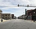
Main Street, downtown
-
Tarboro town seal
-
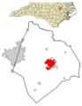
Location in Edgecombe County and the state of North Carolina.
-
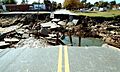
James Street Bridge washed out in Tarboro, North Carolina. FEMA#136, taken by Dave Gatley on November 8, 1999.
-
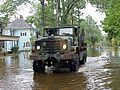
National Guard transporting government documents from flooded building, Tarboro, NC. FEMA#495, taken by Sgt. 1st Class Eric Wedeking September 16, 1999.
-
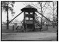
FRONT VIEW – Cotton Press, Albermarle Street (moved from Norfleet Plantation), Tarboro, NC; HABS NC, 33-TARB,2-3
See also
 In Spanish: Tarboro (Carolina del Norte) para niños
