
Jacksonville, North Carolina facts for kids
Quick facts for kids
Jacksonville
|
|||
|---|---|---|---|

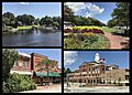
Clockwise from top left: waterfront along New River, LP Willingham Riverfront Park, Court Street, Onslow County Courthouse
|
|||
|
|||
| Nickname(s):
J-Ville, J-Vegas, Marine Town
|
|||
| Motto(s):
"A Caring Community"
|
|||

Location within North Carolina
|
|||

Jacksonville
Location in North Carolina
|
|||
| Country | United States | ||
| State | North Carolina | ||
| County | Onslow | ||
| Founded | 1757 | ||
| Incorporated | 1842 | ||
| Named For | Andrew Jackson | ||
| Area | |||
| • Total | 56.42 sq mi (146.14 km2) | ||
| • Land | 48.80 sq mi (126.40 km2) | ||
| • Water | 7.62 sq mi (19.74 km2) 13.51% | ||
| Elevation | 0 ft (0 m) | ||
| Population
(2020)
|
|||
| • Total | 72,723 | ||
| • Estimate
(2023)
|
72,879 | ||
| • Density | 1,490.16/sq mi (575.35/km2) | ||
| • Urban | 111,224 (US: 302nd) | ||
| • Urban density | 1,470.1/sq mi (567.6/km2) | ||
| • Metro | 213,676 (US: 219th) | ||
| Time zone | UTC−05:00 (EST) | ||
| • Summer (DST) | UTC−04:00 (EDT) | ||
| ZIP Codes |
28540, 28541, 28546
|
||
| Area codes | 910, 472 | ||
| FIPS code | 37-34200 | ||
| GNIS feature ID | 2404784 | ||


Jacksonville is a city located in Onslow County, North Carolina. In 2020, about 72,723 people lived there. This makes it the 14th largest city in North Carolina. Jacksonville is the main city and the most populated place in Onslow County.
It is known for being home to important military bases. These include the United States Marine Corps' Camp Lejeune and New River Air Station. Jacksonville is also very close to North Carolina's beautiful Crystal Coast area. The city is considered the youngest in the United States. This is because many young military families live there.
Contents
A Brief History of Jacksonville
How Jacksonville Began
After the Tuscarora wars ended in 1713, Native American tribes were moved from the area. Then, people started to settle permanently between New Bern and Wilmington. The New River became a key place for making naval supplies like turpentine. Today, the downtown waterfront park is built where Wantland's Ferry used to be.
In 1752, a big hurricane destroyed the county seat of Johnston. So, Wantland's Ferry, which is where Jacksonville is now, was chosen as the new location for the county courthouse. This area was first called Onslow Courthouse. In 1842, the town officially became a city. It was renamed Jacksonville to honor former U.S. President Andrew Jackson. During the American Civil War, a small group led by U.S. Navy Lt. William B. Cushing briefly took over the town in November 1862.
Growth and the Military Presence
For a long time, Jacksonville and Onslow County mostly relied on naval supplies, wood, and tobacco farming. In 1939, Colonel George W. Gillette of the U.S. Army Corps of Engineers mapped the coast from Fort Monroe, Virginia to Fort Sumter, South Carolina. This map included the New River and Onslow County. It helped the military decide to build a training base there.
In 1941, Congress approved money to buy about 100,000 acres (400 km2) along the New River. This led to the creation of Marine Barracks, New River, which later became Camp Lejeune Marine Corps Base. About 700 families had to move from their homes. Landowners were paid, but many sharecroppers who didn't own land did not get money for their houses. Some African American families bought land from Raymond Kellum and started a community called Kellumtown. Other families moved to places like Georgetown, Pickettown, Bell Fork, and Sandy Run. These areas are now part of Jacksonville.
The building of Camp Lejeune caused the town's population to grow very quickly. Jacksonville had only about 800 people before. Many new workers moved in, and the city kept growing with young Marine families and retired military members. Today, Jacksonville's main businesses are retail stores and services. The biggest reason people move to Jacksonville is still the U.S. Marine Corps.
Historic Places and Special Recognition
Several historic places in Jacksonville are listed on the National Register of Historic Places. These include the Bank of Onslow and Jacksonville Masonic Temple, the Mill Avenue Historic District, and the Pelletier House and Wantland Spring.
In 2016, Jacksonville became the first place to have a paid holiday for the 13th Amendment to the United States Constitution. This amendment made slavery illegal in the U.S. and its territories.
Jacksonville's Location and Climate
Where is Jacksonville Located?
Jacksonville covers about 56.42 square miles (146.14 km2). Most of this area, about 48.80 square miles (126.40 km2), is land. The rest, about 7.62 square miles (19.74 km2), is water. The city is about an hour's drive from Wilmington. It is also just 15 minutes from the Intracoastal Waterway, which is a path for boats along the coast.
What is Jacksonville's Climate Like?
Jacksonville has a humid subtropical climate. This means it has hot, humid summers and mild winters. The city gets a good amount of rain throughout the year. Snowfall is very rare.
| Climate data for Jacksonville, North Carolina (Marine Corps Air Station New River) 1991–2020 normals, extremes 1955–present | |||||||||||||
|---|---|---|---|---|---|---|---|---|---|---|---|---|---|
| Month | Jan | Feb | Mar | Apr | May | Jun | Jul | Aug | Sep | Oct | Nov | Dec | Year |
| Record high °F (°C) | 81 (27) |
94 (34) |
92 (33) |
95 (35) |
99 (37) |
101 (38) |
102 (39) |
101 (38) |
97 (36) |
95 (35) |
89 (32) |
82 (28) |
102 (39) |
| Mean maximum °F (°C) | 74.8 (23.8) |
77.4 (25.2) |
82.6 (28.1) |
86.6 (30.3) |
91.6 (33.1) |
95.8 (35.4) |
96.3 (35.7) |
95.2 (35.1) |
91.6 (33.1) |
86.3 (30.2) |
81.0 (27.2) |
75.9 (24.4) |
97.5 (36.4) |
| Mean daily maximum °F (°C) | 56.0 (13.3) |
59.3 (15.2) |
65.8 (18.8) |
74.0 (23.3) |
80.4 (26.9) |
86.5 (30.3) |
89.3 (31.8) |
87.8 (31.0) |
83.3 (28.5) |
75.0 (23.9) |
66.2 (19.0) |
59.0 (15.0) |
73.5 (23.1) |
| Daily mean °F (°C) | 45.6 (7.6) |
48.4 (9.1) |
54.5 (12.5) |
62.9 (17.2) |
70.4 (21.3) |
77.5 (25.3) |
80.9 (27.2) |
79.6 (26.4) |
74.9 (23.8) |
64.9 (18.3) |
55.1 (12.8) |
48.7 (9.3) |
63.6 (17.6) |
| Mean daily minimum °F (°C) | 35.2 (1.8) |
37.5 (3.1) |
43.1 (6.2) |
51.8 (11.0) |
60.5 (15.8) |
68.5 (20.3) |
72.5 (22.5) |
71.4 (21.9) |
66.5 (19.2) |
54.8 (12.7) |
44.0 (6.7) |
38.4 (3.6) |
53.7 (12.1) |
| Mean minimum °F (°C) | 18.3 (−7.6) |
21.8 (−5.7) |
26.5 (−3.1) |
34.5 (1.4) |
46.6 (8.1) |
57.0 (13.9) |
64.3 (17.9) |
62.9 (17.2) |
54.6 (12.6) |
37.8 (3.2) |
27.8 (−2.3) |
23.8 (−4.6) |
16.2 (−8.8) |
| Record low °F (°C) | 0 (−18) |
9 (−13) |
12 (−11) |
25 (−4) |
33 (1) |
45 (7) |
54 (12) |
54 (12) |
44 (7) |
24 (−4) |
19 (−7) |
−5 (−21) |
−5 (−21) |
| Average precipitation inches (mm) | 3.96 (101) |
3.50 (89) |
3.79 (96) |
3.35 (85) |
4.20 (107) |
5.24 (133) |
6.18 (157) |
7.48 (190) |
7.45 (189) |
4.13 (105) |
3.55 (90) |
3.68 (93) |
56.51 (1,435) |
| Average snowfall inches (cm) | 0.4 (1.0) |
0.2 (0.51) |
0.0 (0.0) |
0.0 (0.0) |
0.0 (0.0) |
0.0 (0.0) |
0.0 (0.0) |
0.0 (0.0) |
0.0 (0.0) |
0.0 (0.0) |
0.0 (0.0) |
0.0 (0.0) |
0.6 (1.5) |
| Average precipitation days (≥ 0.01 in) | 10.4 | 9.8 | 10.3 | 8.3 | 10.4 | 11.8 | 13.0 | 13.7 | 10.8 | 9.5 | 9.3 | 10.4 | 127.7 |
| Average snowy days (≥ 0.1 in) | 0.2 | 0.3 | 0.0 | 0.0 | 0.0 | 0.0 | 0.0 | 0.0 | 0.0 | 0.0 | 0.0 | 0.0 | 0.5 |
| Source: NOAA | |||||||||||||
People and Economy in Jacksonville
Who Lives in Jacksonville?
| Historical population | |||
|---|---|---|---|
| Census | Pop. | %± | |
| 1870 | 60 | — | |
| 1880 | 94 | 56.7% | |
| 1890 | 170 | 80.9% | |
| 1900 | 309 | 81.8% | |
| 1910 | 505 | 63.4% | |
| 1920 | 656 | 29.9% | |
| 1930 | 783 | 19.4% | |
| 1940 | 873 | 11.5% | |
| 1950 | 3,960 | 353.6% | |
| 1960 | 13,491 | 240.7% | |
| 1970 | 16,289 | 20.7% | |
| 1980 | 18,237 | 12.0% | |
| 1990 | 30,013 | 64.6% | |
| 2000 | 66,715 | 122.3% | |
| 2010 | 70,145 | 5.1% | |
| 2020 | 72,723 | 3.7% | |
| 2023 (est.) | 72,879 | 3.9% | |
| U.S. Decennial Census 2020 |
|||
In 2020, the city of Jacksonville had 72,723 people. There were 21,986 households and 15,491 families living in the city.
| Race | Number | Percentage |
|---|---|---|
| White (non-Hispanic) | 38,661 | 53.16% |
| Black or African American (non-Hispanic) | 12,728 | 17.5% |
| Native American | 334 | 0.46% |
| Asian | 2,358 | 3.24% |
| Pacific Islander | 432 | 0.59% |
| Other/mixed | 4,670 | 6.42% |
| Hispanic or Latino | 13,540 | 18.62% |
What are the Main Jobs in Jacksonville?

Jacksonville's economy is strongly linked to the military. Many people work for the government or in jobs that support the military bases. Retail stores and services are also very important to the city's economy.
Here are some of the largest employers in Jacksonville:
| # | Employer | # of employees |
|---|---|---|
| 1 | United States Department of Defense | 1000+ |
| 2 | Onslow County Schools | 1000+ |
| 3 | Marine Corps Base Camp Lejeune | 1000+ |
| 4 | Onslow Memorial Hospital | 1000+ |
| 5 | Onslow County | 1000+ |
| 6 | Walmart | 1000+ |
| 7 | Coastal Carolina Community College | 500–999 |
| 8 | Convergys | 500–999 |
| 9 | City of Jacksonville | 500–999 |
| 10 | Food Lion | 250–499 |
| 11 | Coastal Enterprises | 250–499 |
| 12 | McDonald's | 250–499 |
| 13 | Lowe's | 250–499 |
| 14 | Alorica | 250–499 |
| 15 | Stanadyne | 250–499 |
Education in Jacksonville
Public Schools for Students
Onslow County Schools serves most of Jacksonville. However, students living on military bases like Camp Lejeune and Marine Corps Air Station New River attend schools run by the Department of Defense Education Activity (DoDEA).
Here are some of the schools in the area:
Alternative School
- Onslow County Learning Center
Elementary Schools
- Bell Fork Elementary School
- Blue Creek Elementary School
- Carolina Forest Elementary School
- Clyde Erwin Elementary School
- Hunters Creek Elementary School
- Jacksonville Commons Elementary School
- MeadowView Elementary School
- Morton Elementary School
- Northwoods Elementary School
- Parkwood Elementary School
- Silverdale Elementary School
- Southwest Elementary School
- Stateside Elementary School
- Summersill Elementary School
- Thompson Elementary School
- Dixon Elementary School
Middle Schools
- Dixon Middle School
- Hunters Creek Middle School
- Jacksonville Commons Middle School
- Northwoods Park Middle School
- New Bridge Middle School
- Southwest Middle School
High Schools
- Dixon High School
- Jacksonville High School
- Northside High School
- Richlands High School
- Southwest High School
- White Oak High School
- Swansboro High School
Students on MCAS New River go to Delalio Elementary School. They then attend Brewster Middle School and Lejeune High School on Camp Lejeune.
Private Schools in the Area
- Fellowship Christian Academy
- Grace Baptist School
- Infant Of Prague Catholic School
- Jacksonville Christian Academy
- Living Water Christian School
- Montessori Children's School
- St. Anne's Day School
- Shiloh Institute of Learning
- One World Montessori School
Public Magnet Schools
- Clyde Erwin Elementary School (year-round school)
- New Bridge Middle School
- Northwoods Elementary School (year-round school)
- Onslow Virtual Secondary School
Colleges and Higher Education
- Coastal Carolina Community College
- Miller-Motte Technical College - Jacksonville branch
- University of Mount Olive - Jacksonville branch
Charter School
- ZECA School of Arts and Technology
Getting Around Jacksonville
In 2009, Jacksonville was ranked ninth in the U.S. for the number of people who walked to work. This shows that many people in the city choose to walk.
For air travel, people in Jacksonville use Albert J. Ellis Airport. This airport is located in nearby Richlands.
Famous People From Jacksonville
- David Charles Abell, a conductor who was born in Jacksonville.
- Ryan Adams, a singer-songwriter who often mentions Jacksonville in his songs.
- Jones Angell, the play-by-play announcer for the North Carolina Tar Heels.
- Troy Barnett, a former NFL defensive lineman.
- Art Bell, a talk radio host.
- David Braxton, a former NFL player.
- Levi Brown, a former NFL offensive tackle.
- Joe Cannon, a former MLB outfielder.
- Burke Day, a Georgia state legislator and businessman.
- Edward B. Dudley, a former governor and congressman.
- Dave Dunaway, a former NFL player.
- Jacob Evans, an NBA player.
- Chad Fonville, a former MLB player. He played for teams like the Montreal Expos and Boston Red Sox.
- Mike Frier, a former NFL player for the Cincinnati Bengals and Seattle Seahawks.
- David Green, a former NFL and CFL player.
- Sara Hickman, a singer.
- Marcus Jones, a former NFL player for the Tampa Bay Buccaneers.
- Christina Koch, an engineer and NASA astronaut.
- Qasim Mitchell, a former NFL player.
- Quincy Monk, a former NFL player.
- Donte Paige-Moss, a former AFL player.
- Michael R. Nelson, a former mayor of Carrboro. He was the first openly gay mayor in North Carolina.
- Dian Parkinson, a television personality and model.
- Danielle Peck, a singer.
- Andre Purvis, a former NFL player for the Cincinnati Bengals.
- A.J. Styles, a professional wrestler.
- Tyrone Willingham, a former head football coach at the University of Washington and the University of Notre Dame.
Images for kids
-
Clockwise from top left: waterfront along New River, LP Willingham Riverfront Park, Court Street, Onslow County Courthouse
-
Flag of Jacksonville, NC
-
Seal of Jacksonville, NC
-
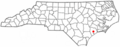
Location of Jacksonville within North Carolina
See also
 In Spanish: Jacksonville (Carolina del Norte) para niños
