Edgecombe County, North Carolina facts for kids
Quick facts for kids
Edgecombe County
|
|||
|---|---|---|---|

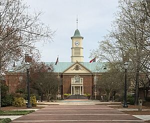
Edgecombe County Courthouse
|
|||
|
|||

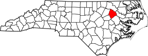
Location within the U.S. state of North Carolina
|
|||
 North Carolina's location within the U.S. |
|||
| Country | |||
| State | |||
| Founded | 1741 | ||
| Named for | Richard Edgcumbe | ||
| Seat | Tarboro | ||
| Largest community | Rocky Mount | ||
| Area | |||
| • Total | 506.87 sq mi (1,312.8 km2) | ||
| • Land | 505.44 sq mi (1,309.1 km2) | ||
| • Water | 1.43 sq mi (3.7 km2) 0.28% | ||
| Population
(2020)
|
|||
| • Total | 48,900 | ||
| • Estimate
(2023)
|
48,832 | ||
| • Density | 96.75/sq mi (37.36/km2) | ||
| Time zone | UTC−5 (Eastern) | ||
| • Summer (DST) | UTC−4 (EDT) | ||
| Congressional district | 1st | ||
Edgecombe County is a county in the state of North Carolina, USA. It's pronounced like "EJ-kum" or "EJ-kohm". In 2020, about 48,900 people lived here. The main town, or county seat, is Tarboro. Edgecombe County is part of the larger Rocky Mount, NC Metropolitan Statistical Area.
Contents
History of Edgecombe County
Long ago, the Tuscarora, a Native American group, lived in the area that is now Edgecombe County. The first European settlers arrived around the 1730s, near the Tar River.
On May 16, 1732, the governor of North Carolina, George Burrington, decided to create a new area called Edgecombe Precinct. It was named after a British politician, Richard Edgcumbe. There was some debate, but in 1741, the area officially became a precinct. No one knows for sure why the spelling of the county's name is a bit different from the person it was named after.
Over the years, parts of Edgecombe County were used to create other counties. For example, Granville County was formed in 1746. Later, in 1758, parts became Halifax County and Dobbs County. In 1777, Nash County was also created from some of its land.
In 1763, Tarboro was chosen as the county seat. The first official U.S. Census in 1790 showed that 10,255 people lived in the county. In 1840, a railroad was built through the county. This helped towns like Rocky Mount, Battleboro, and Sharpsburg grow. By 1850, the county was producing a lot of cotton and had a population of 17,189.
More changes happened in 1855 when parts of Edgecombe and other counties formed Wilson County. After the American Civil War, the economy in eastern North Carolina faced challenges. During the time known as Reconstruction, many formerly enslaved people gained political rights. This led to African Americans being elected to important government roles in the county. In 1871, some parts of Edgecombe County were added to Nash County. This split towns like Battleboro and Sharpsburg between the two counties. In 1883, the county's size was set to what it is today when another piece was given to Wilson County.
From the Reconstruction era until the 1930s, the county's population grew, and new industries developed.
Geography of Edgecombe County
Edgecombe County covers about 506.87 square miles. Most of this is land (505.44 square miles), with a small amount of water (1.43 square miles).
Protected Natural Areas
- Lower Fishing Creek Game Land (part)
- Tar River Game Land
Major Water Bodies
- Cokey Swamp
- Deep Creek
- Fishing Creek
- Swift Creek
- Tar River
- Town Creek
Neighboring Counties
- Halifax County – to the north
- Martin County – to the east
- Pitt County – to the south-southeast
- Wilson County – to the southwest
- Nash County – to the west
Main Roads and Highways

 Future I-87
 US 13
US 13 US 64
US 64
 US 64 Alt. (Princeville)
 US 64 Alt. (Rocky Mount)
 US 258
 US 301
 NC 11
NC 11 NC 33
NC 33 NC 42
NC 42 NC 43
NC 43
 NC 43 Bus.
 NC 97
NC 97 NC 111
 NC 122
 NC 124
 NC 142
Important Transportation Hubs
- Carolina Connector Intermodal Terminal, a large shipping facility owned by CSX Transportation.
- Rocky Mount Station, a train station.
People Living in Edgecombe County (Demographics)
| Historical population | |||
|---|---|---|---|
| Census | Pop. | %± | |
| 1790 | 10,265 | — | |
| 1800 | 10,421 | 1.5% | |
| 1810 | 12,423 | 19.2% | |
| 1820 | 13,276 | 6.9% | |
| 1830 | 14,935 | 12.5% | |
| 1840 | 15,708 | 5.2% | |
| 1850 | 17,189 | 9.4% | |
| 1860 | 17,376 | 1.1% | |
| 1870 | 22,970 | 32.2% | |
| 1880 | 26,181 | 14.0% | |
| 1890 | 24,113 | −7.9% | |
| 1900 | 26,591 | 10.3% | |
| 1910 | 32,010 | 20.4% | |
| 1920 | 37,995 | 18.7% | |
| 1930 | 47,894 | 26.1% | |
| 1940 | 49,162 | 2.6% | |
| 1950 | 51,634 | 5.0% | |
| 1960 | 54,226 | 5.0% | |
| 1970 | 52,341 | −3.5% | |
| 1980 | 55,988 | 7.0% | |
| 1990 | 56,558 | 1.0% | |
| 2000 | 55,606 | −1.7% | |
| 2010 | 56,552 | 1.7% | |
| 2020 | 48,900 | −13.5% | |
| 2023 (est.) | 48,832 | −13.7% | |
| U.S. Decennial Census 1790–1960 1900–1990 1990–2000 2010 2020 |
|||
"Demographics" is about the different groups of people living in an area.
2020 Census Information
In 2020, the census counted 48,900 people living in Edgecombe County. There were 21,151 households (groups of people living together) and 14,408 families.
Here's a look at the different groups of people:
| Group | Number | Percentage |
|---|---|---|
| White (not Hispanic) | 17,340 | 35.46% |
| Black or African American (not Hispanic) | 27,299 | 55.83% |
| Native American | 128 | 0.26% |
| Asian | 112 | 0.23% |
| Pacific Islander | 9 | 0.02% |
| Other/Mixed | 1,306 | 2.67% |
| Hispanic or Latino | 2,706 | 5.53% |
2010 Census Information
At the 2010 census, there were 56,552 people in the county.
- 57.4% were Black or African American.
- 38.8% were White.
- 0.3% were Native American.
- 0.2% were Asian.
- 2.3% were of some other race.
- 1.0% were of two or more races.
- 3.7% were Hispanic or Latino (this group can be of any race).
Economy
The economy of Edgecombe County has seen changes. The unemployment rate, which is the percentage of people looking for jobs who can't find them, has been going down. In June 2024, it was 6.1 percent.
Education
Edgecombe County Public Schools manages 14 schools. These schools serve students from pre-kindergarten all the way up to the thirteenth grade. There are four high schools, four middle schools, five elementary schools, and one school that teaches grades K-8. This school system was created in 1993 when the old Edgecombe County Schools and Tarboro City Schools joined together.
The county also has Edgecombe Community College, with campuses in Tarboro and Rocky Mount.
Communities
City
- Rocky Mount (This is the biggest community, and part of it is also in Nash County.)
Towns
- Conetoe
- Leggett
- Macclesfield
- Pinetops
- Princeville
- Sharpsburg
- Speed
- Tarboro (This is the county seat, where the main county offices are.)
- Whitakers
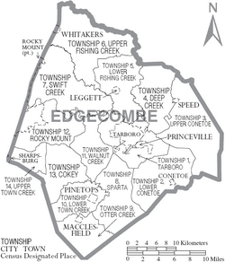
Townships
The county is divided into smaller areas called townships. There are fourteen of them, and they have both numbers and names:
- 1 (Tarboro)
- 2 (Lower Conetoe)
- 3 (Upper Conetoe)
- 4 (Deep Creek)
- 5 (Lower Fishing Creek)
- 6 (Upper Fishing Creek)
- 7 (Swift Creek)
- 8 (Sparta)
- 9 (Otter Creek)
- 10 (Lower Town Creek)
- 11 (Walnut Creek)
- 12 (Rocky Mount)
- 13 (Cokey)
- 14 (Upper Town Creek)
Unincorporated Communities
These are smaller communities that are not officially part of a city or town.
Notable People from Edgecombe County
- Duncan Lamont Clinch (1787–1849) – Born in Edgecombe County, he was an American Army officer. He fought in the First and Second Seminole Wars.
- Dorsey Pender (1834–1863) – Born in Edgecombe County, he became a Major General in the Confederate Army.
- Josiah Pender (1819-1864) – A cousin of Dorsey Pender, he captured Fort Macon from Union soldiers in 1861.
- Hugh Shelton (born 1942) – He was a four-star General and led the Joint Chiefs of Staff, a very important military position, chosen by President Clinton.
See also
 In Spanish: Condado de Edgecombe para niños
 | Tommie Smith |
 | Simone Manuel |
 | Shani Davis |
 | Simone Biles |
 | Alice Coachman |


