Martin County, North Carolina facts for kids
Quick facts for kids
Martin County
|
|||
|---|---|---|---|

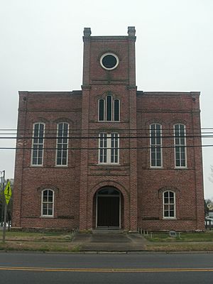
Old Martin County Courthouse in Williamston
|
|||
|
|||

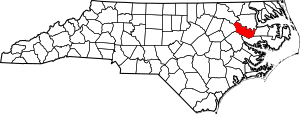
Location within the U.S. state of North Carolina
|
|||
 North Carolina's location within the U.S. |
|||
| Country | |||
| State | |||
| Founded | March 14, 1774 | ||
| Named for | Josiah Martin | ||
| Seat | Williamston | ||
| Largest community | Williamston | ||
| Area | |||
| • Total | 456.70 sq mi (1,182.8 km2) | ||
| • Land | 456.41 sq mi (1,182.1 km2) | ||
| • Water | 0.29 sq mi (0.8 km2) 0.06% | ||
| Population
(2020)
|
|||
| • Total | 22,031 | ||
| • Estimate
(2023)
|
21,447 | ||
| • Density | 48.27/sq mi (18.64/km2) | ||
| Time zone | UTC−5 (Eastern) | ||
| • Summer (DST) | UTC−4 (EDT) | ||
| Congressional district | 1st | ||
Martin County is a place in North Carolina, a state in the United States. In 2020, about 22,031 people lived here. The main town and where the county government is located is called Williamston.
Contents
History of Martin County
This county was formed in 1774. It was created from parts of Halifax County and Tyrrell County. The county was named after Josiah Martin. He was the last royal governor of North Carolina from 1771 to 1775. A "royal governor" was a leader chosen by the king of England before the United States became independent.
Even though other counties named after royal governors were changed after America became independent, Martin County kept its name. The historic Martin County Courthouse was added to the National Register of Historic Places in 1979. This means it is an important building to protect.
Geography of Martin County
Martin County covers about 456.70 square miles. Most of this area, about 456.41 square miles, is land. Only a small part, about 0.29 square miles, is water.
Protected Areas and Sites
- Fort Branch Civil War Site
- Lower Roanoke River Wetlands Game Land (part of a larger area)
Major Water Bodies
- Conoho Creek
- Etheridge Creek
- Gardiners Creek
- Hardison Mill Creek
- Long Creek
- Roanoke River
- Smithwick Creek
- Tranters Creek
- Welch Creek
Neighboring Counties
Martin County shares borders with these other counties:
- Bertie County – to the northeast
- Washington County – to the east
- Beaufort County – to the southeast
- Pitt County – to the southwest
- Edgecombe County – to the west
- Halifax County – to the northwest
Main Roads and Highways

 Future I-87
 US 13
US 13 US 17
US 17 US 64
US 64
 US 64 Alt.
 US 64 Bus.
 NC 11
NC 11 NC 42
NC 42 NC 111
 NC 125
 NC 142
 NC 171
 NC 903
Important Buildings and Facilities
- Martin County Airport
People of Martin County
| Historical population | |||
|---|---|---|---|
| Census | Pop. | %± | |
| 1790 | 6,010 | — | |
| 1800 | 5,629 | −6.3% | |
| 1810 | 5,987 | 6.4% | |
| 1820 | 6,320 | 5.6% | |
| 1830 | 8,539 | 35.1% | |
| 1840 | 7,637 | −10.6% | |
| 1850 | 8,307 | 8.8% | |
| 1860 | 10,195 | 22.7% | |
| 1870 | 9,647 | −5.4% | |
| 1880 | 13,140 | 36.2% | |
| 1890 | 15,221 | 15.8% | |
| 1900 | 15,383 | 1.1% | |
| 1910 | 17,797 | 15.7% | |
| 1920 | 20,828 | 17.0% | |
| 1930 | 23,400 | 12.3% | |
| 1940 | 26,111 | 11.6% | |
| 1950 | 27,938 | 7.0% | |
| 1960 | 27,139 | −2.9% | |
| 1970 | 24,730 | −8.9% | |
| 1980 | 25,948 | 4.9% | |
| 1990 | 25,078 | −3.4% | |
| 2000 | 25,593 | 2.1% | |
| 2010 | 24,505 | −4.3% | |
| 2020 | 22,031 | −10.1% | |
| 2023 (est.) | 21,447 | −12.5% | |
| U.S. Decennial Census 1790–1960 1900–1990 1990–2000 2010 2020 |
|||
2020 Census Information
The 2020 census counted 22,031 people living in Martin County. There were 9,378 households and 6,195 families. The table below shows the different groups of people living in the county based on the census.
| Group | Number of People | Percentage |
|---|---|---|
| White (not Hispanic or Latino) | 11,528 | 52.33% |
| Black or African American (not Hispanic or Latino) | 8,868 | 40.25% |
| Native American | 69 | 0.31% |
| Asian | 98 | 0.44% |
| Pacific Islander | 1 | 0.0% |
| Other/Mixed | 572 | 2.6% |
| Hispanic or Latino | 895 | 4.06% |
Education in Martin County
The public schools in Martin County are managed by Martin County Schools. This school district covers the entire county. For higher education, Martin Community College is located in Williamston.
Communities in Martin County
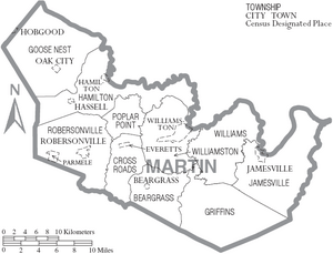
Towns
- Bear Grass
- Everetts
- Hamilton
- Hassell
- Jamesville
- Oak City
- Parmele
- Robersonville
- Williamston (This is the county seat and the largest community.)
Townships
- Bear Grass
- Cross Roads
- Goose Nest
- Griffins
- Hamilton
- Jamesville
- Poplar Point
- Robersonville
- Williams
- Williamston
Notable People from Martin County
- Annie Moore Cherry, a professor, author, and playwright.
- Wilber Hardee, who started the famous restaurant chain Hardee's.
- William Drew Robeson I, a minister at Witherspoon Street Presbyterian Church.
See also
 In Spanish: Condado de Martin (Carolina del Norte) para niños
 | May Edward Chinn |
 | Rebecca Cole |
 | Alexa Canady |
 | Dorothy Lavinia Brown |


