Bertie County, North Carolina facts for kids
Quick facts for kids
Bertie County
|
|||
|---|---|---|---|

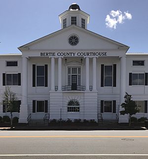
Bertie County Courthouse in Windsor
|
|||
|
|||

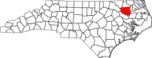
Location within the U.S. state of North Carolina
|
|||
 North Carolina's location within the U.S. |
|||
| Country | |||
| State | |||
| Founded | 1739 | ||
| Named for | James Bertie and/or Henry Bertie | ||
| Seat | Windsor | ||
| Largest community | Windsor | ||
| Area | |||
| • Total | 741.31 sq mi (1,920.0 km2) | ||
| • Land | 699.18 sq mi (1,810.9 km2) | ||
| • Water | 42.13 sq mi (109.1 km2) 5.61% | ||
| Population
(2020)
|
|||
| • Total | 17,934 | ||
| • Estimate
(2023)
|
16,922 | ||
| • Density | 25.65/sq mi (9.90/km2) | ||
| Time zone | UTC−5 (Eastern) | ||
| • Summer (DST) | UTC−4 (EDT) | ||
| Congressional district | 1st | ||
Bertie County is a county in the northeast part of North Carolina, a state in the United States. In 2020, about 17,934 people lived there. The main town and county seat is Windsor. The area became Bertie Precinct in 1722 and a full county in 1739.
Contents
History of Bertie County
Bertie County started as "Bertie Precinct" in 1722. It was formed from a part of Chowan Precinct. The county was named after James Bertie or his brother Henry Bertie. They were both "Lords Proprietors" of Carolina, which means they owned and helped manage the land.
Over time, parts of Bertie Precinct were used to create other counties. In 1729, parts of Bertie and other areas formed Tyrrell Precinct. When Albemarle County was no longer a county in 1739, all its precincts became separate counties.
As more people moved in, Bertie County was split again in 1741. This created Edgecombe County and Northampton County. Later, in 1759, parts of Bertie, Chowan, and Northampton counties formed Hertford County. Bertie's borders have stayed the same since then.
For a long time, Bertie County was mostly rural. Its economy depended on farming. In the past, important crops were tobacco and cotton. These crops were grown by enslaved Native American and African people. After the Civil War, farming remained very important. Today, some people call the area the "Inner Banks." It is becoming popular for people who want to retire or buy vacation homes. They enjoy the beaches and natural beauty.
Geography of Bertie County
Bertie County covers about 741 square miles. Most of this area, about 699 square miles, is land. The rest, about 42 square miles, is water.
Protected Natural Areas
Bertie County has several special places where nature is protected.
National Protected Area
State and Local Protected Areas
- Bachelor Bay Game Land (part)
- Bertie County Game Land
- Chowan Swamp Game Land (part)
- Historic Hope Plantation
- Jamesville Wildlife Preserve
- Lewiston Woodville Preserve
- Lower Roanoke River Wetlands Game Land (part)
- Salmon Creek State Natural Area
- Upper Roanoke River Wetlands Game Land (part)
Major Water Bodies
Many rivers and swamps flow through Bertie County.
- Albemarle Sound
- Beaverdam Swamp
- Cashie River
- Chowan River
- Chinkapin Swamp
- Cucklemaker Creek
- Cypress Swamp
- Falt Swamp Creek
- Hoggard Mill Creek
- Loosing Swamp
- Middle River
- Quioccosin Creek
- Roanoke River
- Stoney Creek
- Wahton Swamp
- Wildcat Swamp
Neighboring Counties
Bertie County shares its borders with several other counties:
- Hertford County – to the north
- Chowan County – to the east
- Washington County – to the southeast
- Martin County – to the south
- Halifax County – to the west
- Northampton County – to the northwest
Main Roads
Several important highways pass through Bertie County:

 Future I-87
 US 13
US 13
 US 13 Bus.
 US 17
US 17
 US 17 Bus.
 US 17 Byp.
 NC 11
NC 11
 NC 11 Bus.
 NC 42
NC 42 NC 45
NC 45 NC 305
 NC 308
Other Important Structures
- Sans Souci Ferry, a ferry that crosses the Cashie River.
People of Bertie County
| Historical population | |||
|---|---|---|---|
| Census | Pop. | %± | |
| 1790 | 12,462 | — | |
| 1800 | 11,249 | −9.7% | |
| 1810 | 11,218 | −0.3% | |
| 1820 | 10,805 | −3.7% | |
| 1830 | 12,262 | 13.5% | |
| 1840 | 12,175 | −0.7% | |
| 1850 | 12,851 | 5.6% | |
| 1860 | 14,310 | 11.4% | |
| 1870 | 12,950 | −9.5% | |
| 1880 | 16,399 | 26.6% | |
| 1890 | 19,176 | 16.9% | |
| 1900 | 20,538 | 7.1% | |
| 1910 | 23,039 | 12.2% | |
| 1920 | 23,993 | 4.1% | |
| 1930 | 25,844 | 7.7% | |
| 1940 | 26,201 | 1.4% | |
| 1950 | 26,439 | 0.9% | |
| 1960 | 24,350 | −7.9% | |
| 1970 | 20,528 | −15.7% | |
| 1980 | 21,024 | 2.4% | |
| 1990 | 20,388 | −3.0% | |
| 2000 | 19,773 | −3.0% | |
| 2010 | 21,282 | 7.6% | |
| 2020 | 17,934 | −15.7% | |
| 2023 (est.) | 16,922 | −20.5% | |
| U.S. Decennial Census 1790–1960 1900–1990 1990–2000 2010 2020 |
|||
Population in 2020
In 2020, there were 17,934 people living in Bertie County. There were 7,909 households and 4,733 families.
| Race | Number | Percentage |
|---|---|---|
| White (not Hispanic) | 6,298 | 35.12% |
| Black or African American (not Hispanic) | 10,674 | 59.52% |
| Native American | 57 | 0.32% |
| Asian | 63 | 0.35% |
| Other/Mixed | 512 | 2.85% |
| Hispanic or Latino | 330 | 1.84% |
Bertie County has the highest percentage of Black residents compared to all other counties in North Carolina.
Population in 2010
In 2010, there were 21,282 people in the county. About 62.5% were Black or African American. About 35.2% were White. Other groups included Asian, Native American, and people of two or more races. About 1.3% of the people were Hispanic or Latino.
Education in Bertie County
Public schools in Bertie County are managed by Bertie County Schools. Some well-known schools in the county include Bertie High School, Lawrence Academy, and Bethel Assembly Christian Academy. For the 2021–2022 school year, the state rated the county school system as "low-performing." This means they are working to improve student results.
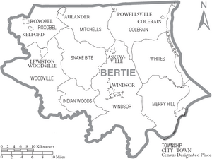
Communities in Bertie County
Towns
- Askewville
- Aulander
- Colerain
- Kelford
- Lewiston Woodville
- Powellsville
- Roxobel
- Windsor (This is the county seat and the largest town.)
Townships
- Colerain
- Indian Woods
- Merry Hill
- Mitchells
- Roxobel
- Snakebite
- Whites
- Windsor
- Woodville
Unincorporated Communities
These are smaller communities that are not officially towns.
- Ashland
- Avoca
- Baker Town
- Buena Vista
- Elm Grove
- Gatlinsville
- Grabtown
- Greens Cross
- Hexlena
- Merry Hill
- Midway
- Perrytown
- Pine Ridge
- Quitsna
- Republican
- Rosemead
- Sans Souci
- Spring Branch
- Todds Cross
- Trap
- Whites Cross
- Woodard
Town Population Ranking
This table shows the towns in Bertie County from largest to smallest, based on the 2020 census.
† = county seat
| Rank | Name | Type | Population (2020 census) |
|---|---|---|---|
| 1 | † Windsor | Town | 3,582 |
| 2 | Aulander | Town | 763 |
| 3 | Lewiston Woodville | Town | 426 |
| 4 | Colerain | Town | 217 |
| 5 | Kelford | Town | 203 |
| 6 | Powellsville | Town | 189 |
| 7 | Askewville | Town | 184 |
| 8 | Roxobel | Town | 179 |
See also
 In Spanish: Condado de Bertie para niños
 | Toni Morrison |
 | Barack Obama |
 | Martin Luther King Jr. |
 | Ralph Bunche |


