Windsor, North Carolina facts for kids
Quick facts for kids
Windsor, North Carolina
|
||
|---|---|---|

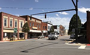
South King Street
|
||
|
||

Location of Windsor, North Carolina
|
||
| Country | ||
| State | ||
| County | Bertie | |
| Area | ||
| • Total | 2.81 sq mi (7.29 km2) | |
| • Land | 2.81 sq mi (7.29 km2) | |
| • Water | 0.00 sq mi (0.00 km2) | |
| Elevation | 0 ft (0 m) | |
| Population
(2020)
|
||
| • Total | 3,582 | |
| • Density | 1,272.47/sq mi (491.22/km2) | |
| Time zone | UTC-5 (Eastern (EST)) | |
| • Summer (DST) | UTC-4 (EDT) | |
| ZIP code |
27983 27959
|
|
| Area code(s) | 252 | |
| FIPS code | 37-74680 | |
| GNIS feature ID | 2406899 | |
Windsor is a town in North Carolina, USA. It's the main town, or county seat, of Bertie County. In 2020, about 3,582 people lived here. Windsor is part of North Carolina's Inner Banks, an area known for its rivers and coastal plains.
Contents
History of Windsor
The land where Windsor is located was historically the home of the Tuscarora people. Today, some Tuscarora residents still live in a village called Tandequemuc, which is now known as Merry Hill.
Many important historical places in and around Windsor are listed on the National Register of Historic Places. These include the Bertie County Courthouse, Bertie Memorial Hospital, and several historic homes like Elmwood and Hope Plantation. The Windsor Historic District also protects many old buildings.
In August 2020, a strong tornado hit areas just outside Windsor. This tornado was caused by Hurricane Isaias. It damaged many homes and was one of the strongest tornadoes ever caused by a tropical storm since 2005.
Fun Things to Do in Windsor
Windsor is a great place for kayaking and canoeing. The Cashie River flows through the town, and its waters are usually calm. You can rent canoes and kayaks from the Town of Windsor and the Roanoke Cashie River Center to explore the river.
Parks and Recreation Facilities
The Town of Windsor has many places for outdoor activities and fun:
- Livermon Park and Mini Zoo
- Cashie Wetlands Walk and Canoe Trail
- Craftsman and Farmers Museum
- Hoggard Mill Road Bridge Access
- Cashie River Campground
- Cashie Disk Golf Course
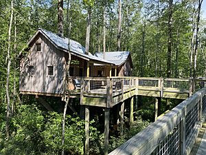
- Cashie River Tree Houses
- Windsor Tennis Courts
- Rotary Park
- Tuscarora village of Tandequemuc Longhouse
- Williford Park
- Cashie River ADAAG Fishing Piers and ADAAG Small Boat Launch and Trail
Geography of Windsor
Windsor covers a total area of about 7.3 square kilometers (2.81 square miles). All of this area is land, meaning there are no large lakes or significant bodies of water within the town limits.
Population and People
The population of Windsor has changed over the years. In 2000, there were 2,283 people. By 2010, the population grew to 3,630. In the most recent 2020 census, the population was 3,582 people.
Who Lives in Windsor?
The people living in Windsor come from different backgrounds. The US Census collects information about race and ethnicity. Here's a look at the population in 2020:
| Race / Ethnicity (NH = Non-Hispanic) | Pop 2000 | Pop 2010 | Pop 2020 | % 2000 | % 2010 | % 2020 |
|---|---|---|---|---|---|---|
| White alone (NH) | 1,035 | 1,173 | 1,137 | 45.34% | 32.31% | 31.74% |
| Black or African American alone (NH) | 1,206 | 2,264 | 2,188 | 52.83% | 62.37% | 61.08% |
| Native American or Alaska Native alone (NH) | 8 | 25 | 29 | 0.35% | 0.69% | 0.81% |
| Asian alone (NH) | 15 | 71 | 39 | 0.66% | 1.96% | 1.09% |
| Pacific Islander alone (NH) | 1 | 0 | 0 | 0.04% | 0.00% | 0.00% |
| Other Race alone (NH) | 0 | 1 | 8 | 0.00% | 0.03% | 0.22% |
| Mixed race or Multiracial (NH) | 10 | 56 | 101 | 0.44% | 1.54% | 2.82% |
| Hispanic or Latino (any race) | 8 | 40 | 80 | 0.35% | 1.10% | 2.23% |
| Total | 2,283 | 3,630 | 3,582 | 100.00% | 100.00% | 100.00% |
Famous People from Windsor
Many notable people have come from Windsor, North Carolina:
- Frank Ballance (1942–2019), a member of the United States House of Representatives.
- Kent Bazemore (born 1989), a professional basketball player in the NBA.
- William Blount (1749–1800), who helped write the US Constitution and was a Senator for Tennessee.
- Norma Bonniwell King (1877–1961), a talented architect.
- David Outlaw (1806–1868) and George Outlaw (1771–1825), both served in the United States House of Representatives.
- Bosh Pritchard (1919–1996), an NFL football player.
- Jethro Pugh (1944–2015), an NFL football player for the Dallas Cowboys.
- Tootie Robbins (1958–2020), another NFL football player.
- Francis D. Winston (1857–1941), a former Lieutenant Governor and judge in North Carolina.
- George T. Winston (1852–1932), an educator and university leader, and brother to Francis.
Education in Windsor
Students in Windsor attend schools within the Bertie County Public Schools system. Some of the schools include:
- Bertie High School
- Bertie STEM High School (focuses on Science, Technology, Engineering, and Math)
- Bertie Early College High School
- Heritage Collegiate Academy
See also
 In Spanish: Windsor (Carolina del Norte) para niños
 | James Van Der Zee |
 | Alma Thomas |
 | Ellis Wilson |
 | Margaret Taylor-Burroughs |


