
Roxobel, North Carolina facts for kids
Quick facts for kids
Roxobel, North Carolina
|
|
|---|---|
 |
|
| Nickname(s):
Peanut Town, Red Refuge, North Kelford
|
|

Location of Roxobel, North Carolina
|
|
| Country | United States |
| State | North Carolina |
| County | Bertie |
| Area | |
| • Total | 1.04 sq mi (2.70 km2) |
| • Land | 1.04 sq mi (2.70 km2) |
| • Water | 0.00 sq mi (0.00 km2) |
| Elevation | 92 ft (28 m) |
| Population
(2020)
|
|
| • Total | 179 |
| • Density | 179.29/sq mi (69.23/km2) |
| Time zone | UTC-5 (Eastern (EST)) |
| • Summer (DST) | UTC-4 (EDT) |
| ZIP code |
27872
|
| Area code(s) | 252 |
| FIPS code | 37-58180 |
| GNIS feature ID | 2407254 |
Roxobel is a small and historic town located in the northwestern part of Bertie County, North Carolina, in the United States. Its story began way back in 1724. At first, it was known as Cotten's Cross Roads. Over the years, the town's name changed a few times. Finally, in 1849, it became Roxobel, and it has kept that name ever since. According to the 2020 census, about 179 people live in Roxobel.
Contents
- Exploring Roxobel's Past: A Town's Journey
- Roxobel's Location and Size
- Who Lives in Roxobel? Population Facts
- Images for kids
- See also
Exploring Roxobel's Past: A Town's Journey
Roxobel Township is in the northwest corner of Bertie County, North Carolina. It includes the towns of Roxobel and Kelford. This area covers about 60 square miles of farms and old plantations. It stretches from Roxobel in the north down to Woodville in the south. To the west is the Roanoke River, and to the east is the border of Aulander.
How Roxobel Got Started: Early Beginnings
Roxobel is the older of the two towns, dating back to the early 1700s. In 1719, a man named John Cotten bought a large piece of land. This land was in what is now Bertie County and Hertford County. His son, Samuel Cotten, had already settled in the area that would become Roxobel.
The settlement was built where two roads met. One road went south to the Roanoke River, and the other went west. Because of the Cotten family, this spot was first called Cotten's Cross Roads.
New Names for the Town: Granberys and Brittons
In 1756, the Cotten family moved away. The Granbery family then moved into the area. William Granbery was a plantation owner. Thomas Granbery worked with timber and furniture. Around 1808, the town was renamed Granberys Cross Roads. This might have been to remember William Granbery, who passed away that year.
Later, around 1815, a successful merchant named William Britton moved to the area. He bought the general store and took over the post office by 1819. The town then became known as Britton's Store or Britton's Cross Roads. However, the post office thought this name was too similar to another place. So, in December 1847, the town was renamed Roxobel. This new name came from a popular novel called Roxobel, written in 1831 by Mary Martha Sherwood.
Community Growth: Churches and Lodges
As more people moved to the area, the community grew. The Bertie Church was started in 1740. It became an independent Baptist church in 1750. In the early 1800s, the church moved and was called Sandy Run Baptist Church. Even when it moved back to town in 1854, it kept the name Sandy Run.
A special group called a masonic lodge was also formed in 1799. It was called Davie Lodge No. 39. This group had about 20 important landowners and business people as members.
Roxobel's Boom: Trade and Transportation
By 1830, steamboats could travel on the Roanoke River. A small landing spot, Norfleet's Ferry, was only two miles south of Roxobel. This helped the town grow as a trading center. Roxobel also got a railroad connection in 1888 when the Roanoke and Tar Railroad opened. This brought new success to the town.
By 1906, Roxobel had nearly 400 people. It had six retail stores, a wholesale store, two churches, and a school. One church was St. Marks Episcopal Church, started in 1881. The school was Roxobel Academy, which opened in 1890 with about 30 students. The Bank of Roxobel opened in 1908 to help with the town's growing business needs.
Kelford: Roxobel's Neighboring Town
The town of Kelford is two miles south of Roxobel. It was planned in 1890 because of the new Norfolk and Carolina Railroad. Kelford's train station opened, and the town became official in 1892. It had stores, a hotel, a Baptist church, a school, and a bank. By 1910, Kelford had over 300 people. In 1914, a Coca-Cola bottling plant opened there, becoming a major employer.
Kelford grew quickly at first. However, during the Great Depression, many businesses closed. The hotel and bank shut down, and Kelford's school joined with Roxobel's.
Facing Natural Disasters: Tornadoes in Roxobel
Roxobel has faced tough times due to powerful storms. In 1943, a tornado tore through the town. Six people lost their lives, and there was a lot of damage. Twenty-five homes and 12 store buildings were completely destroyed. The Methodist church was lifted into the air and smashed. About 50 other buildings were also badly damaged. More tornadoes in 1984 and 1988 caused similar destruction.
Historical Plantations: A Look at the Past
Besides the towns, Roxobel Township also had several large plantations. These were big farms where crops like cotton were grown.
Woodbourne and Kelford Plantations
Stephen Andrews Norfleet (1822-1910) was one of the biggest plantation owners. He had several cotton plantations in Bertie County. His father started the Woodbourne estate around 1810. Stephen inherited it in 1838. Kelford Plantation began when Stephen Norfleet bought land in 1848-1850. He built a home called Kelford on the land, which later gave its name to the nearby town.
Pineview Plantation
The Pineview plantation started in 1835 when Joshua Brown bought land. By 1850, he had a large farm used for livestock, corn, peas, sweet potatoes, and cotton. His son, Joseph Henry Browne, took over the farm in 1856 and made it even bigger.
Oaklana Plantation
The Oaklana plantation was created in 1825 by Perry Cotten Tyler. He bought land north of Roxobel to grow corn and cotton. His son, John E. Tyler, took over the plantation in 1886. Besides farming, John was a scholar who studied Latin and Greek. He also published poetry and invented many tools for farming.
Today, some of these historic plantations, like Oaklana, Pineview, and Woodbourne, are listed on the National Register of Historic Places. This means they are important historical sites.
Roxobel's Location and Size
According to the United States Census Bureau, the town of Roxobel covers an area of about 2.7 square kilometers (or 1.04 square miles). All of this area is land, with no water.
Who Lives in Roxobel? Population Facts
| Historical population | |||
|---|---|---|---|
| Census | Pop. | %± | |
| 1900 | 227 | — | |
| 1910 | 491 | 116.3% | |
| 1920 | 330 | −32.8% | |
| 1930 | 334 | 1.2% | |
| 1940 | 332 | −0.6% | |
| 1950 | 394 | 18.7% | |
| 1960 | 452 | 14.7% | |
| 1970 | 347 | −23.2% | |
| 1980 | 278 | −19.9% | |
| 1990 | 244 | −12.2% | |
| 2000 | 263 | 7.8% | |
| 2010 | 240 | −8.7% | |
| 2020 | 187 | −22.1% | |
| U.S. Decennial Census | |||
Let's look at the people who live in Roxobel. In the year 2000, there were 263 people living in the town. These people lived in 112 households, and 72 of those were families.
The population of Roxobel is made up of different groups. In 2000, about 51% of the people were White, and about 46% were African American. A small number of people were from other races or had mixed backgrounds.
The average household in Roxobel had about 2.35 people. The average family had about 2.90 people. About 26.8% of households had children under 18 living with them. About 18.8% of households had someone living alone who was 65 years old or older.
The age of people in Roxobel varies. In 2000, about 21% of the population was under 18 years old. About 23% were between 25 and 44 years old. And about 22% were 65 years old or older. The average age in the town was 42 years.
The median income for a household in Roxobel was $28,393 in 2000. This means that half of the households earned more than this amount, and half earned less. About 12.3% of all the people in Roxobel lived below the poverty line. This included about 11.1% of children under 18.
Images for kids
-
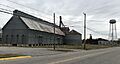
A view of Roxobel, North Carolina.
-

Map showing the location of Roxobel in North Carolina.
See also
 In Spanish: Roxobel (Carolina del Norte) para niños
