Tyrrell County, North Carolina facts for kids
Quick facts for kids
Tyrrell County
|
|||
|---|---|---|---|

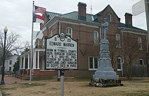
Tyrrell County Courthouse in Columbia
|
|||
|
|||

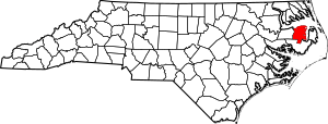
Location within the U.S. state of North Carolina
|
|||
 North Carolina's location within the U.S. |
|||
| Country | |||
| State | |||
| Founded | 1729 | ||
| Named for | Sir John Tyrrell | ||
| Seat | Columbia | ||
| Largest community | Columbia | ||
| Area | |||
| • Total | 597.18 sq mi (1,546.7 km2) | ||
| • Land | 390.78 sq mi (1,012.1 km2) | ||
| • Water | 206.40 sq mi (534.6 km2) 34.56% | ||
| Population
(2020)
|
|||
| • Total | 3,245 | ||
| • Estimate
(2023)
|
3,461 | ||
| • Density | 8.30/sq mi (3.20/km2) | ||
| Time zone | UTC−5 (Eastern) | ||
| • Summer (DST) | UTC−4 (EDT) | ||
| Congressional district | 1st | ||
Tyrrell County is a county in the state of North Carolina, USA. It is pronounced "TAIR-il". In 2020, about 3,245 people lived here. This makes it the county with the smallest population in North Carolina. The main town and county seat is Columbia. Tyrrell County started in 1729.
Contents
History of Tyrrell County
Tyrrell County was first created in 1729. It was called Tyrrell Precinct back then. A "precinct" was like an early version of a county. It was formed from parts of other areas like Bertie, Chowan, Currituck, and Pasquotank.
The county was named after Sir John Tyrrell. He was one of the "Lords Proprietors of Carolina." These were eight English noblemen who were given control of the Carolina colony by the King.
In 1739, Tyrrell Precinct officially became Tyrrell County. Over the years, parts of Tyrrell County were used to create other counties. For example, Martin County was formed in 1774. Later, Washington County was created in 1799. In 1870, part of Tyrrell County helped form Dare County.
Geography and Nature
Tyrrell County covers about 597 square miles. About 391 square miles of this is land, and 206 square miles is water. This means a big part of the county, about 34.56%, is water!
Because it's close to the Outer Banks, Tyrrell County is part of an area called the Inner Banks. This region has many rivers, sounds, and wetlands.
Wildlife in Tyrrell County
Tyrrell County is home to many interesting animals and plants. You might find bears and even rare red wolves here. Unique plants like pitcher plants also grow in the area.
Protected Natural Areas
Many parts of Tyrrell County are protected to keep nature safe. These areas are great for exploring and seeing wildlife.
- Pocosin Lakes National Wildlife Refuge (part)
- Alligator River Game Land
- Buckridge Coastal Reserve Dedicated Nature Preserve
- Buckridge Game Land
- Emily and Richardson Preyer Buckridge Coastal Reserve
- J. Morgan Futch Game Land
- Lantern Acres Game Land (part)
- New Lake Game Land
- Palmetto-Peartree Preserve
- Pettigrew State Park (part)
- Texas Plantation Game Land
Major Water Bodies
The county has several important rivers and sounds. These waterways are vital for the environment and local life.
Neighboring Counties
Tyrrell County shares borders with several other counties:
- Perquimans County – to the north
- Pasquotank County – to the north
- Camden County – to the north
- Currituck County – to the northeast
- Dare County – to the east
- Hyde County – to the south
- Washington County – to the west
- Chowan County – to the northwest
Main Roads
These are the major highways that run through Tyrrell County:
 US 64
US 64
 US 64 Bus.
 NC 94
NC 94
Population and People
| Historical population | |||
|---|---|---|---|
| Census | Pop. | %± | |
| 1790 | 4,826 | — | |
| 1800 | 3,395 | −29.7% | |
| 1810 | 3,364 | −0.9% | |
| 1820 | 4,319 | 28.4% | |
| 1830 | 4,732 | 9.6% | |
| 1840 | 4,657 | −1.6% | |
| 1850 | 5,133 | 10.2% | |
| 1860 | 4,944 | −3.7% | |
| 1870 | 4,173 | −15.6% | |
| 1880 | 4,545 | 8.9% | |
| 1890 | 4,225 | −7.0% | |
| 1900 | 4,980 | 17.9% | |
| 1910 | 5,219 | 4.8% | |
| 1920 | 4,849 | −7.1% | |
| 1930 | 5,164 | 6.5% | |
| 1940 | 5,556 | 7.6% | |
| 1950 | 5,048 | −9.1% | |
| 1960 | 4,520 | −10.5% | |
| 1970 | 3,806 | −15.8% | |
| 1980 | 3,975 | 4.4% | |
| 1990 | 3,856 | −3.0% | |
| 2000 | 4,149 | 7.6% | |
| 2010 | 4,407 | 6.2% | |
| 2020 | 3,245 | −26.4% | |
| 2023 (est.) | 3,461 | −21.5% | |
| U.S. Decennial Census 1790–1960 1900–1990 1990–2000 2010 2020 |
|||
The 2020 census counted 3,245 people living in Tyrrell County. This makes it the county with the fewest people in North Carolina.
The population of Tyrrell County was highest in 1940, with 5,556 residents. Since then, the number of people has gone down. This is partly because there are fewer job opportunities in the area. Between 2010 and 2020, the population dropped by 26%. This was the biggest percentage drop in population for any county in North Carolina.
Economy and Jobs
Tyrrell County's economy mainly relies on farming. Potatoes are the biggest crop grown here. Forestry (working with trees and wood) and fishing are also important jobs.
The county also has a small tourism industry. People visit for activities like hunting, fishing, and watching birds. Tyrrell County faces challenges with poverty and food insecurity. This means some people might struggle to get enough food.
Communities in Tyrrell County
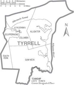
Tyrrell County has one main town and several smaller communities.
Town
- Columbia (This is the county seat and the largest community.)
Townships
Townships are smaller areas within the county.
- Alligator
- Columbia
- Gum Neck
- Scuppernong
- South Fork
Unincorporated Communities
These are small communities that are not officially part of a town.
- Fort Landing
- Frying Pan
- Jerry
- Pleasant View
- Kilkenny
See also
 In Spanish: Condado de Tyrrell para niños
 | John T. Biggers |
 | Thomas Blackshear |
 | Mark Bradford |
 | Beverly Buchanan |


