Hyde County, North Carolina facts for kids
Quick facts for kids
Hyde County
|
||
|---|---|---|

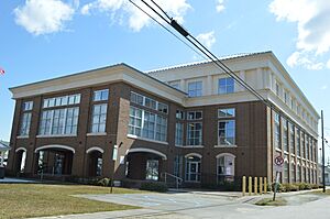
Hyde County Courthouse in Swan Quarter
|
||
|
||

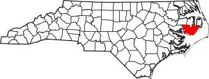
Location within the U.S. state of North Carolina
|
||
 North Carolina's location within the U.S. |
||
| Country | ||
| State | ||
| Founded | 1712 | |
| Named for | Edward Hyde | |
| Seat | Swan Quarter | |
| Largest community | Ocracoke | |
| Area | ||
| • Total | 1,459.05 sq mi (3,778.9 km2) | |
| • Land | 612.35 sq mi (1,586.0 km2) | |
| • Water | 846.70 sq mi (2,192.9 km2) 58.03% | |
| Population
(2020)
|
||
| • Total | 4,589 | |
| • Estimate
(2023)
|
4,607 | |
| • Density | 7.49/sq mi (2.89/km2) | |
| Time zone | UTC−5 (Eastern) | |
| • Summer (DST) | UTC−4 (EDT) | |
| Congressional district | 3rd | |
Hyde County is a county in North Carolina, USA. In 2020, about 4,589 people lived there. This makes it the second-least populated county in North Carolina. Its main town, or county seat, is Swan Quarter. The county started in 1705 as Wickham Precinct. It was renamed Hyde Precinct in 1712 and became a full county in 1739.
Contents
Hyde County's Past: A Look at History
How Hyde County Began
Historians are not sure exactly when Europeans first settled in the area that is now Hyde County. The oldest land records found are from 1704 or 1705. Not many Europeans lived there for a long time. The English built a small fort on the north side of Lake Mattamuskeet.
In 1711, Native American groups, including the Tuscarora people, fought against the settlers. This war was called the Tuscarora War. The settlers won in 1715. Many Native Americans were taken as slaves. Others were forced to leave North Carolina.
Local Algonquin natives moved to the new Mattamuskeet Reservation. This reservation covered most of the eastern part of what is now Hyde County. Over time, settlers pressured the Native Americans to sell their land. By 1792, all the reservation land was sold. The Native Americans either left or married local European and African Americans.
Becoming a County
Hyde County was first formed on December 3, 1705. It was called Wickham Precinct. It was one of three areas within Bath County. The name Wickham came from a family home in England. This was the home of John Archdale, who was a governor.
In 1712, its name changed to Hyde Precinct. This new name honored Edward Hyde. He was the Governor of North Carolina from 1711 to 1712. In 1739, Bath County was removed, and Hyde Precinct became Hyde County. In 1745, Lake Mattamuskeet and its nearby land became part of Hyde County.
Changes Before the Civil War
After the Revolutionary War, new towns and churches started to form. In 1819, a part of Hyde County west of the Pungo River joined Beaufort County. Four years later, an area from Currituck County became part of Hyde County. This area included Hatteras Island.
From 1834 to 1865, Native American children were placed with white families. This program was called "apprenticeship." It meant they would learn jobs. But it also caused them to lose much of their Native American culture. In 1845, Ocracoke Island became part of Hyde County. Ocracoke had a small shipping business. The mainland part of the county was mostly farms. Farmers found it hard to grow crops in the swampy land. People also fished and collected oysters. In 1860, about 37% of Hyde's population were enslaved people.
Hyde County's Later Years
When the American Civil War started, people in Hyde County had different ideas. Many joined the Confederate army. Some small fights happened in the county in 1863 and 1864. Many enslaved people ran away to areas held by the Union army to become free.
After the war, during the Reconstruction era, some people moved out of Hyde. In 1870, Hyde County became its current size. Its northeastern part joined with other areas to form Dare County. Investors from the North became interested in the county's timber. Between 1870 and 1920, the county's economy grew. This was because of logging cypress, juniper, and oak trees. Several sawmills and railroads were built.
The timber business slowed down as fewer trees were left. Then, the Great Depression hit, causing more problems. Hyde County got its first paved road in the 1920s. Electric service came in 1935.
By the mid-1900s, the county's economy was struggling. It relied on farming and did not get new industries. Many towns that were once busy became empty. Most people in the county were poor. The timber industry still provided some jobs. After World War II, the seafood packing business grew.
During this time, Jim Crow laws caused racial segregation. Black people had fewer chances for jobs and political power than white people. In 1950, only some white homes had hot water and flushing toilets. No black homes had these things. Black families often lived near small creeks. On Ocracoke Island, black and white people lived closer together.
Hyde County's Land and Nature
Hyde County covers about 1,459 square miles. About 612 square miles are land, and 846 square miles are water. This means 58% of the county is water. It is the second-largest county in North Carolina by total area. Hyde County has a mainland part and Ocracoke Island. Ocracoke Island is part of the Outer Banks.
Hyde County shares borders with several other counties. These include Dare, Tyrrell, Washington, Beaufort, Pamlico, and Carteret counties. The mainland part of the county is next to the Pamlico Sound. Ocracoke Island is on the Atlantic Ocean.
Hyde County has many swamps. The land is very flat. Its highest point is only about 18 feet above sea level. Because it is so low, the county often floods. Saltwater can also get into the soil. Lake Mattamuskeet is the biggest natural lake in North Carolina.
Hyde County is on the Atlantic Flyway. This is a path for many migrating birds. You can see tundra swan and Canada geese there at different times of the year.
Special Protected Areas
Hyde County has several national and state protected areas. These places help protect nature and wildlife.
National Protected Areas
- Alligator River National Wildlife Refuge (part)
- Cape Hatteras National Seashore (part)
- Mattamuskeet National Wildlife Refuge
- Pocosin Lakes National Wildlife Refuge (part)
- Swanquarter National Wildlife Refuge
- Swanquarter Wilderness
State and Local Protected Areas
- Dare Game Land (part)
- Emily and Richardson Preyer Buckridge Reserve (part)
- Gull Rock Game Land
- Hatteras Inlet Crab Spawning Sanctuary (part)
- New Lake Game Land
- Pungo River Game Land
Major Water Bodies
Many important water areas are found in or near Hyde County.
- Albemarle Sound
- Alligator Lake
- Alligator River
- Atlantic Ocean (North Atlantic Ocean)
- Hatteras Inlet
- Intracoastal Waterway
- Lake Mattamuskeet
- Ocracoke Inlet
- Pamlico River
- Pamlico Sound
- Pungo Lake
- Pungo River
- Raleigh Bay
Main Roads and Transportation
Major Highways
 US 264
 NC 12
NC 12 NC 45
NC 45 NC 94
NC 94 NC 99
NC 99
Major Transportation
- Cedar Island–Ocracoke Ferry (to Carteret County)
- Hatteras–Ocracoke Ferry (to Dare County)
- Swan Quarter–Ocracoke Ferry
People of Hyde County: Demographics
| Historical population | |||
|---|---|---|---|
| Census | Pop. | %± | |
| 1790 | 4,204 | — | |
| 1800 | 4,829 | 14.9% | |
| 1810 | 6,029 | 24.8% | |
| 1820 | 4,967 | −17.6% | |
| 1830 | 6,184 | 24.5% | |
| 1840 | 6,458 | 4.4% | |
| 1850 | 7,636 | 18.2% | |
| 1860 | 7,732 | 1.3% | |
| 1870 | 6,445 | −16.6% | |
| 1880 | 7,765 | 20.5% | |
| 1890 | 8,903 | 14.7% | |
| 1900 | 9,278 | 4.2% | |
| 1910 | 8,840 | −4.7% | |
| 1920 | 8,386 | −5.1% | |
| 1930 | 8,550 | 2.0% | |
| 1940 | 7,860 | −8.1% | |
| 1950 | 6,479 | −17.6% | |
| 1960 | 5,765 | −11.0% | |
| 1970 | 5,571 | −3.4% | |
| 1980 | 5,873 | 5.4% | |
| 1990 | 5,411 | −7.9% | |
| 2000 | 5,826 | 7.7% | |
| 2010 | 5,810 | −0.3% | |
| 2020 | 4,589 | −21.0% | |
| 2023 (est.) | 4,607 | −20.7% | |
| U.S. Decennial Census 1790–1960 1900–1990 1990–2000 2010 2020 |
|||
Who Lives in Hyde County?
| Race | Number | Percentage |
|---|---|---|
| White (not Hispanic) | 2,928 | 63.8% |
| Black or African American (not Hispanic) | 1,152 | 25.1% |
| Native American | 7 | 0.15% |
| Asian | 7 | 0.15% |
| Pacific Islander | 2 | 0.04% |
| Other/Mixed | 146 | 3.18% |
| Hispanic or Latino | 347 | 7.56% |
In 2020, 4,589 people lived in Hyde County. This makes it the second-least populated county in North Carolina.
Population Changes Over Time
Hyde County's population was highest in 1900, with 9,278 people. Between 1900 and 2000, the number of people living there dropped by almost half. From 2010 to 2020, Hyde's population went down by 21 percent. This was one of the biggest drops in population in North Carolina.
Hyde County's Economy
Hyde County is one of the counties in North Carolina that faces economic challenges. Its economy relies on farming, fishing, and tourism. Most businesses are on Ocracoke Island. They mainly serve tourists who visit the area.
Education in Hyde County
Hyde County has the smallest public school system in North Carolina. The Hyde County Schools system has two schools.
- Mattamuskeet School, for grades K-12, serves the mainland.
- Ocracoke School, for grades K-12, serves Ocracoke Island.
There is also a small private Mennonite school in the northwest part of the county. This school serves the Mennonite community.
In 2022, about 16.4 percent of people in Hyde County had a college degree or higher.
Healthcare in Hyde County
Hyde County's last hospital closed in 2014. It is one of only three counties in North Carolina without private dental offices.
Culture and Traditions
Hyde County is a popular place for fishing, bear hunting, and duck hunting. Ocracoke Island attracts many tourists. Most families living in Hyde County have lived there for many generations. Many black and white families share the same last names.
Historically, people from mainland Hyde County and Ocracoke Island often spoke a special dialect of English called Hoi Toider. This way of speaking has become less common over time. Since the 1970s, younger African Americans in the area tend to speak a dialect more like urban African-American Vernacular English.
Media in Hyde County
Hyde County has two full-power radio stations. These are WKHC 97.1 FM and WCMS-FM 94.5. They are licensed to Hatteras, NC.
Ocracoke Island has WOVV 90.1 FM. This is a low-power, non-commercial station.
WHYC 88.5 FM is located at Mattamuskeet School in Swan Quarter. WHYC is one of only two high school-run radio stations in North Carolina.
Communities in Hyde County
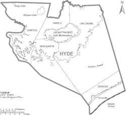
Hyde County does not have any official cities or towns. It is divided into five townships: Currituck, Fairfield, Lake Landing, Ocracoke, and Swan Quarter.
Census-Designated Places
These are areas that the U.S. Census Bureau defines for statistics.
- Engelhard
- Fairfield
- Ocracoke (the largest community)
- Swan Quarter (the county seat)
Unincorporated Communities
These are smaller communities not officially part of a town or city.
- Germantown
- Last Chance
- Nebraska
- Scranton
- Ponzer
- Sladesville
Townships
- Currituck
- Fairfield
- Lake Landing
- Ocracoke
- Swan Quarter
There used to be a sixth township called Mattamuskeet. Now, this area is "unorganized territory." It is mostly taken up by the federally controlled Mattamuskeet National Wildlife Refuge.
See also
 In Spanish: Condado de Hyde (Carolina del Norte) para niños
 | May Edward Chinn |
 | Rebecca Cole |
 | Alexa Canady |
 | Dorothy Lavinia Brown |


