
Ocracoke, North Carolina facts for kids
Quick facts for kids
Ocracoke
|
|
|---|---|

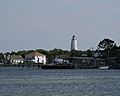
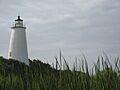
Ocracoke Lighthouse seen from Ocracoke Harbor
|
|

Ocracoke
Location in North Carolina
|
|
| Country | |
| State | |
| County | Hyde |
| Named for | Ocracoke Inlet |
| Area | |
| • Total | 9.62 sq mi (24.91 km2) |
| • Land | 8.60 sq mi (22.27 km2) |
| • Water | 1.02 sq mi (2.64 km2) |
| Elevation | 3 ft (1 m) |
| Population
(2020)
|
|
| • Total | 797 |
| • Density | 92.69/sq mi (35.79/km2) |
| Time zone | UTC−05:00 (Eastern (EST)) |
| • Summer (DST) | UTC−04:00 (EDT) |
| ZIP Code |
27960
|
| Area code(s) | 252 |
| FIPS code | 37-48740 |
| GNIS feature ID | 1021718 |
| Demonym | Ococker |
Ocracoke (pronounced OH-krə-kohk) is a small town and island located at the southern end of Ocracoke Island in North Carolina. It's part of Hyde County, North Carolina. In 2020, about 797 people lived there.
You can only reach Ocracoke Island by ferry, private boat, or private plane, as there are no bridges connecting it to the mainland. The main road, North Carolina Highway 12, uses ferries to link to other islands and the mainland. The island's economy mainly relies on tourism and commercial fishing.
Ocracoke is famous for its unique way of speaking English, called the Hoi Toider accent. This accent is slowly changing as more people visit and move to the island. Ocracoke Island is also known as the place where the famous pirate Blackbeard died in 1718. During World War II, German submarines sank British ships nearby, and the bodies of four sailors washed ashore. They are buried in a special cemetery on the island, honored each year.
Because it's so far out in the Atlantic Ocean, Ocracoke Island often gets hit by tropical cyclones. For example, Hurricane Dorian in 2019 damaged the main road, North Carolina Highway 12.
Contents
Island History and Early Settlers
In the 1500s, the Hatteras or Croatan peoples lived on Ocracoke and Hatteras islands. These Native Americans spoke a language called Algonquian. They made a special "black drink" or "yaupon tea" from a native holly plant, which they used in ceremonies. By the mid-1700s, the Hatteras people had mostly disappeared, some due to diseases from Europe, others by marrying European settlers.
In 1524, Italian explorer Giovanni da Verrazzano described the area, but he couldn't sail into the shallow waters of Pamlico Sound. Later, in 1585, Sir Walter Raleigh's ship, the Tiger, got stuck in Ocracoke Inlet. His crew had to land on the island for repairs. Early English attempts to settle nearby Roanoke Island failed. This meant no permanent European settlements happened until 1663.
Ocracoke Island was a popular hiding spot for pirates before it was settled. The famous pirate Blackbeard often used it as a safe harbor. He was killed on the island in a fierce battle with troops from Virginia on November 22, 1718. The area known as Springer's Point Nature Preserve is said to have been his hideout.


The island was permanently settled around 1750. In 1715, the state assembly created "Pilot Town." This town was home to skilled ship pilots who helped smaller ships navigate the tricky inlet into Pamlico Sound. As more people moved to the mainland, there was a greater need to move goods from large ocean ships to smaller boats. Warehouses were built on Ocracoke to store these goods before they were sent to towns along the mainland rivers.
By the late 1800s, the shipping business declined. The United States Life-Saving Service became a main source of jobs for local men. Fishing also grew in importance, including trips for tourists.
Today, important historical places like the Ocracoke Historic District, Ocracoke Light Station, and Salter-Battle Hunting and Fishing Lodge are listed on the National Register of Historic Places. Ocracoke has faced many strong hurricanes over the years, including major storms in 1933, 1944, 1949, and 2019. After Hurricane Dorian in 2019, the island was closed to visitors for repairs to the road and sand dunes. It reopened in December 2019.
Fort Ocracoke and the Civil War

During the start of the American Civil War, the Confederate army built a fort called Fort Ocracoke. It was located on Beacon Island in Ocracoke Inlet, about two miles from Ocracoke village. This fort was built on the site of an older fort from the War of 1812. At one point, nearly 500 Confederate soldiers were stationed around Ocracoke and the fort.
However, after the Union army won battles on nearby Hatteras Island, the Confederates left and partly destroyed Fort Ocracoke in August 1861. Union forces then completely destroyed it a month later. After hurricanes in 1933, Beacon Island and the fort sank beneath the waves. The remains of Fort Ocracoke were found and identified in 1998.
Modern Energy Project
In May 2021, Ocracoke was chosen by the United States Department of Energy to join a special program. This program helps remote communities like Ocracoke improve their electricity systems. The goal is to make them stronger against natural disasters and power outages. Ocracoke's project is looking into using electricity for its ferry fleet. Electric ferries would make it easier to evacuate during hurricanes and reduce the island's reliance on fossil fuels.
Island Geography and Features

Ocracoke Island is part of the Outer Banks of North Carolina, a chain of barrier islands. Over time, Ocracoke has sometimes been connected to Hatteras Island. The modern "Hatteras Inlet," which separates the two islands, was created by a powerful storm in 1846. This storm, known as the Great Gale of 1846, also opened another inlet called Oregon Inlet.
Ocracoke is one of the most remote islands in the Outer Banks. You can only get there by one of three public ferries, a private boat, or a private plane. Most of the island, except for Ocracoke village and a few other small areas, is part of the Cape Hatteras National Seashore.

The village of Ocracoke is built around a small, protected harbor called Silver Lake. There's also a smaller residential area along man-made canals called Oyster Creek. The village is located at the widest part of the island, protected from the Atlantic Ocean by sand dunes and a salt marsh. The island is very low, usually less than 5 feet (1.5 meters) above sea level. Many buildings are built on stilts to protect them from flooding, which is a big risk during hurricanes and large storms. The Ocracoke Lighthouse, near Silver Lake, has been working continuously since 1823.

The island is also home to a special British cemetery. During World War II, German submarines sank several British ships, including the HMT Bedfordshire. The bodies of British sailors washed ashore and were buried in this cemetery. A British flag flies there all the time, and the Commonwealth War Graves Commission looks after the site. The United States Coast Guard station on Ocracoke Island helps maintain the property. A memorial ceremony is held every May to honor these sailors.
Ocracoke village is located at coordinates 35°6′46″N 75°58′33″W. The entire island is considered a census-designated place (CDP) with a total area of about 9.6 square miles (24.9 square kilometers). Most of this area is land, with a small portion being water.
Island Climate
Ocracoke has a humid subtropical climate. This means it has hot, humid summers and cool, windy winters. It rains a lot throughout the year, especially in August and September. The highest temperature ever recorded was 99°F (37°C), and the lowest was 13°F (-11°C). The ocean water is usually warm enough for swimming from late May to early October.
Transportation and Public Services
The main road on Ocracoke Island is NC 12. It runs from the village to the ferry dock at the northern tip of the island. From there, a free, one-hour ferry connects to Hatteras Island. Another ferry dock in the village offers toll connections to Swan Quarter on the mainland and Cedar Island. There's also a passenger ferry that goes to the deserted village of Portsmouth.
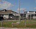
The Ocracoke Island Airport (W95) is located near the village, allowing small planes to land.
Because Ocracoke is so far out in the Atlantic, it's often in the path of tropical cyclones. This is one reason why building a bridge to the island is difficult. The long travel time between Ocracoke and other parts of Hyde County means that people on Ocracoke have not had much interaction with the rest of the county.
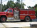
The island has its own fire department, the Ocracoke Volunteer Fire Department, which is run by Hyde County.
Island Economy
Tourism on Ocracoke

.svg)
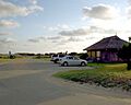
The economy of Ocracoke Island is almost entirely based on tourism. In the winter, the population shrinks, and only a few businesses stay open. But in the spring, summer, and early fall, many tourists arrive. They stay in hotels, campgrounds, and rental houses. Day visitors also come by ferry from Hatteras Island.
During the tourist season, many businesses open, including bars, a brewery, dozens of restaurants, and many shops. Visitors can find unique handmade goods, imported items, and rare antiques, which is special for such a small island.
Fishing Industry

Commercial fishing is also important to the local economy. Sport fishing charters attract tourists who want to fish. With easy access to Pamlico Sound, the Atlantic coast, and the Gulf Stream, Ocracoke offers many fishing opportunities. You can catch small fish from the Sound or larger fish like tuna and drum in the ocean.
Winter Life
In the winter, the main jobs on the island are in construction, with the North Carolina Department of Transportation, and in businesses that support the small local population. Many islanders use the winter as a break because they often work 60 to 80 hours a week during the busy tourist season.
Local Dialect
Ocracoke Island and other parts of the Outer Banks have a very distinct way of speaking English. It's often called a brogue or the High Tider dialect. People sometimes say "hoi toide" instead of "high tide." However, because more tourists visit and there's more contact with the mainland, this unique accent is changing and becoming more like other dialects.
Population and Demographics
The population of Ocracoke has changed over the years:
- 1790: 168 people
- 1800: 139 people
- 1850: 536 people
- 1980: 658 people
- 1990: 713 people
- 2000: 769 people
- 2010: 948 people
- 2020: 797 people
As of the 2020 United States census, there were 797 people living in Ocracoke. Most residents were White (87.08%), with 10.66% identifying as Hispanic or Latino.
In 2010, there were 948 people. About 96.2% were White, and 19.1% were Hispanic or Latino. The average age was 46 years old.


Education and Culture
Children on Ocracoke Island attend the Ocracoke School, which serves students from kindergarten through 12th grade. In 2019, about 186 students attended the school. The BHM Regional Library also has a branch inside the Ocracoke School and Community Library.
In Ocracoke, figs and fig cake are very popular foods. The town even has an annual fig festival that includes a fig cake contest!
Ocracoke has its own radio station, WOVV, known as "Ocracoke Community Radio." The Ocracoke Observer is the local newspaper, which covers island events. Its website is updated daily, and a print edition comes out monthly from March to December.
Images for kids
-

Howard Street
-
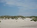
Sand dunes
-
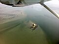
Fort Ocracoke
-

Ocracoke Island
-
View of Ocracoke Lighthouse across Silver Lake
-
British Cemetery
-

Sunset over Silver Lake Harbor
-

Many touristic places on the island refer to piracy in their design. They are often decorated with a "Jolly Roger", including the purported flag of Blackbeard.
-
Ocracoke Island Lighthouse
-
Ocracoke School
-
Ocracoke Airport
-
Ocracoke Volunteer Fire Department
See also
 In Spanish: Ocracoke (Carolina del Norte) para niños
