Cedar Island, North Carolina facts for kids
Cedar Island is a small island and community located in Carteret County, North Carolina, United States. In 2005, about 350 people lived there. The special mail code for Cedar Island is 28520.
Contents
History of Cedar Island
Long ago, before European settlers arrived, Native American people lived on Cedar Island.
In 2019, a big storm called Hurricane Dorian hit the island. The ocean water rose very high, covering parts of the island. Many buildings were damaged. Some wild horses and cows were swept away by the floodwaters. Amazingly, three cows were later found on North Core Banks, which is several miles away! They had swum for many hours to reach safety.
Getting Around Cedar Island
There are only two main roads on Cedar Island. If you are coming from the north, NC-12 is the only road that leads to Cedar Island without needing a ferry. This road crosses the Monroe Gaskill Memorial Bridge.
If you are leaving Cedar Island, NC-12 continues from the ferry terminal. It connects the island to U.S. Route 70 on the mainland, near a community called Sea Level.
The Cedar Island ferry terminal is a place where you can catch a boat. These ferries can take you across the Pamlico Sound to places like Swan Quarter and Ocracoke Island.
Life on Cedar Island
Many people who live on Cedar Island work as fishermen. However, fishing in the area is not as common as it used to be. Another main job for people here is working for the North Carolina Ferry System.
There are three churches on the island: a Methodist church, a Free Will Baptist church, and a Primitive Baptist church. The Methodist and Free Will Baptist churches have regular meetings and Sunday services. You can also find a few small local businesses on the island.
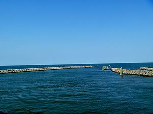
Cedar Island is about 4 miles (6.4 km) long. It stretches from a small village called "Lola" on one end, near the Core Sound, all the way up to the Ferry Station on the north side, which borders the Pamlico Sound. The main part of Cedar Island, once known as "Roe," is in the middle of the island. There is a special harbor there for fishing boats.
Cedar Island has sandy beaches. Behind the beaches, you can find trees like Juniper, Cedar, and pine. More than half of Cedar Island is part of the Cedar Island Wildlife Refuge. This refuge is a protected area for animals and nature. You can go hiking there, and there's a visitor center with information at the south end of the island. There are also places where people can launch their boats into the water.
Weather on Cedar Island
The weather on Cedar Island is usually milder than places further inland. Summers are a bit cooler, and winters are warmer. It doesn't often get below freezing (32°F or 0°C) in winter, and temperatures usually don't go above 90°F (32°C) in summer. Sometimes, in the fall, hurricanes can hit the island.
Nearby Places
- Atlantic - 10 miles (16 km) south
- Sea Level - 10 miles (16 km) southwest on NC-12
- Ocracoke - 23 miles (37 km) northeast across Pamlico Sound
- Portsmouth - 20 miles (32 km) east across Core Sound
- Beaufort - 35 miles (56 km) southwest on NC-12 & US-70
- Swan Quarter - north across Pamlico Sound
See also
 In Spanish: Isla Cedar (Carolina del Norte) para niños
 | Sharif Bey |
 | Hale Woodruff |
 | Richmond Barthé |
 | Purvis Young |


