
Core Banks, North Carolina facts for kids

|
|

Core Banks
Location in North Carolina
|
|
| Geography | |
|---|---|
| Location | Southern Outer Banks, Carteret County, North Carolina, United States |
| Coordinates | 34°42′23″N 76°27′32″W / 34.70639°N 76.45889°W |
| Administration | |
|
United States
|
|
| Nearest city | Harkers Island, NC |
| Governing body | National Park Service |
| Demographics | |
| Population | no permanent population |
| Pop. density | 0 /km2 (0 /sq mi) |
The Core Banks are a chain of barrier islands in North Carolina. They are part of the famous Outer Banks and the Cape Lookout National Seashore. These islands got their name from the Coree tribe, who once lived in the area.
The Core Banks stretch from Ocracoke Inlet all the way to Cape Lookout. They are made up of two main, flat, narrow islands: North Core Banks and South Core Banks. Since 2011, there are also two smaller islands. Different water channels, called inlets, now separate these islands. These include New Drum Inlet, Old Drum Inlet, and Ophelia Inlet.
Today, no one lives permanently on the Core Banks. However, in the past, places like Portsmouth (at the north end of North Core Banks) were busy ports. Also, Cape Lookout Village, near the Cape Lookout Lighthouse, has historic buildings. These include the Lookout Life-Saving Station, a U.S. Coast Guard Station, and old island homes.
Contents
Getting There
You can reach the Core Banks islands by taking a ferry. Two ferries carry vehicles across Core Sound. One goes from Atlantic to North Core Banks. The other travels from Davis to South Core Banks.
Once you are on the islands, there are no paved roads. Instead, vehicles drive right on the beach or use special four-wheel-drive tracks. If you are just visiting, passenger ferries can take you from Harkers Island directly to the Cape Lookout area. This area is at the southern tip of South Core Banks.
Portsmouth Village is located on Portsmouth Island. This island is mostly connected to North Core Banks. You can usually walk or drive between them when the tide is low.
Island History
The Core Banks have a rich history. Several important places here are listed on the National Register of Historic Places. These include the Cape Lookout Coast Guard Station, the Cape Lookout Light Station, and the Cape Lookout Village Historic District. These sites help us remember the past of these unique islands.
Island Geography

The shape of the Core Banks has changed a lot over time. For example, in the mid-1800s, South Core Banks was connected to the Shackleford Banks. Over the years, new inlets have opened, and old ones have closed. These changes are often caused by strong storms like hurricanes.
Here are some of the inlets that have shaped the islands:
- Whalebone Inlet (now closed) used to separate Portsmouth Island from the Core Banks.
- Swash Inlet (now closed) was another old inlet.
- Old Drum Inlet closed in 1971 but was reopened by Hurricane Irene in 2011.
- New Drum Inlet was created by the U.S. Army Corps of Engineers in 1971.
- Ophelia Inlet opened during Hurricane Ophelia in 2005.
- Cedar Inlet (now closed) was another passage.
- Barden Inlet opened after a hurricane in 1933. This inlet now separates Shackleford Banks from South Core Banks.
The islands are located in different areas called Townships within Carteret County. These include Portsmouth, Atlantic, Sea Level, Stacy, Davis, Smyrna, and Harkers Island.
Island Climate
The Core Banks have a humid subtropical climate. This means they have hot and humid summers, cool winters, and rain throughout the year. In summer, a cool sea breeze often blows in the afternoon. However, it can get very hot and humid, with "feels like" temperatures reaching 100 °F (38 °C) or more.
The islands are often hit by hurricanes, especially during the Atlantic hurricane season. This season runs from June 1 to November 30, with the most active time being late August through September. In winter, it can get quite cold and windy, with "feels like" temperatures dropping below 10 °F (-12 °C). The area is good for plants that can handle temperatures down to about 15.3 °F (-9.3 °C). There is usually less than 2 inches (5 cm) of snow each winter. The strongest winter storms, called nor'easters, usually happen in February.
| Climate data for Core Banks, NC (1981-2010 Averages) | |||||||||||||
|---|---|---|---|---|---|---|---|---|---|---|---|---|---|
| Month | Jan | Feb | Mar | Apr | May | Jun | Jul | Aug | Sep | Oct | Nov | Dec | Year |
| Mean daily maximum °F (°C) | 52.8 (11.6) |
54.4 (12.4) |
60.0 (15.6) |
67.1 (19.5) |
74.1 (23.4) |
80.9 (27.2) |
83.9 (28.8) |
83.2 (28.4) |
79.7 (26.5) |
71.9 (22.2) |
64.5 (18.1) |
56.2 (13.4) |
69.1 (20.6) |
| Daily mean °F (°C) | 45.6 (7.6) |
47.4 (8.6) |
53.1 (11.7) |
60.7 (15.9) |
68.4 (20.2) |
76.1 (24.5) |
79.4 (26.3) |
78.5 (25.8) |
74.5 (23.6) |
65.4 (18.6) |
57.4 (14.1) |
49.1 (9.5) |
63.0 (17.2) |
| Mean daily minimum °F (°C) | 38.5 (3.6) |
40.5 (4.7) |
46.2 (7.9) |
54.4 (12.4) |
62.6 (17.0) |
71.2 (21.8) |
74.9 (23.8) |
73.8 (23.2) |
69.4 (20.8) |
59.0 (15.0) |
50.3 (10.2) |
41.9 (5.5) |
57.0 (13.9) |
| Average precipitation inches (mm) | 4.54 (115) |
3.68 (93) |
4.44 (113) |
3.34 (85) |
4.20 (107) |
4.45 (113) |
5.98 (152) |
7.25 (184) |
6.59 (167) |
4.51 (115) |
4.05 (103) |
4.01 (102) |
57.04 (1,449) |
| Average relative humidity (%) | 72.9 | 73.6 | 72.0 | 72.7 | 74.8 | 77.9 | 80.8 | 79.2 | 78.3 | 75.4 | 76.0 | 74.4 | 75.7 |
| Average dew point °F (°C) | 37.4 (3.0) |
39.4 (4.1) |
44.3 (6.8) |
51.9 (11.1) |
60.1 (15.6) |
68.7 (20.4) |
73.0 (22.8) |
71.5 (21.9) |
67.3 (19.6) |
57.4 (14.1) |
49.9 (9.9) |
41.3 (5.2) |
55.3 (12.9) |
| Source: PRISM | |||||||||||||
| Climate data for Cape Hatteras, NC Ocean Water Temperature (64 NE Core Banks) | |||||||||||||
|---|---|---|---|---|---|---|---|---|---|---|---|---|---|
| Month | Jan | Feb | Mar | Apr | May | Jun | Jul | Aug | Sep | Oct | Nov | Dec | Year |
| Daily mean °F (°C) | 49 (9) |
46 (8) |
52 (11) |
59 (15) |
68 (20) |
74 (23) |
78 (26) |
80 (27) |
77 (25) |
70 (21) |
58 (14) |
55 (13) |
64 (18) |
| Source: NOAA | |||||||||||||
Island Plants and Animals
The Core Banks are home to specific types of plants. The main plants you would find here are Live oak trees and Sea Oats (Uniola paniculata). These plants grow well in sandy, coastal areas. The overall plant life here looks like a Coastal Prairie.
Gallery
-
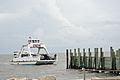
Access by ferry
-
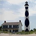
Cape Lookout Lighthouse and Keeper's Quarters.
-
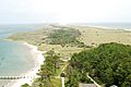
View from Cape Lookout Lighthouse looking North East
-
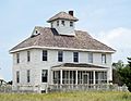
Cape Lookout Coast Guard Station
-
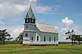
Portsmouth church
-
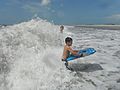
Bodyboarding near Great Island cabins
-
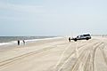
Surf fishing
-
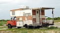
Recreational vehicle customized for beach driving and surf fishing.
-
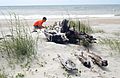
In 1976, about 1,500 vehicles were removed from the island. Few remain.
-
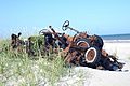
Many shipwreck remains can be found on the beaches
-
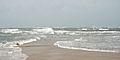
Confusing wave patterns at the beach at Cape Lookout point. Waves are coming from several directions.
-

Fires are allowed on the beach


