Hatteras Island facts for kids
|
Nickname: Croatoan Island
|
|
|---|---|

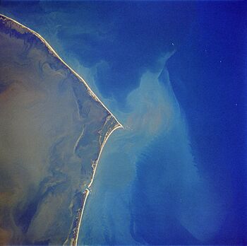
Hatteras Island as seen in a satellite photo. North is to the upper left corner.
|
|
| Lua error in Module:Location_map at line 420: attempt to index field 'wikibase' (a nil value). | |
| Geography | |
| Location | Atlantic Ocean, Pamlico Sound |
| Area | 85.56 km2 (33.03 sq mi) |
| Length | 68 km (42.3 mi) |
Hatteras Island, once called Croatoan Island, is a long, thin island off the coast of North Carolina. It's a barrier island, which means it acts like a natural wall. It separates the big Atlantic Ocean from the calmer Pamlico Sound. This island is part of North Carolina's famous Outer Banks.
Hatteras Island is home to several small communities. These include Rodanthe, Waves, Salvo, Avon, Buxton, Frisco, and Hatteras. A large part of the island is protected as the Cape Hatteras National Seashore. Long ago, Croatoan Native Americans lived here before Europeans arrived.
The island covers about 85.56 square kilometers (33 square miles). In 2010, about 4,322 people lived there. Hatteras Island is a popular spot for fun water sports. People enjoy sport fishing, surfing, windsurfing, and kiteboarding. Hatteras Village is even known as the "Blue Marlin Capital of the World."
Hatteras Island is one of the longest islands in the contiguous United States. It stretches about 68 kilometers (42 miles) in a straight line. Because it's a low-lying barrier island, it faces challenges from sea level rise. Some parts of the island have shrunk quite a bit over time.
Contents
Island History: Exploring Hatteras's Past
Ancient Times: The Croatoan People
The first people to live on Hatteras Island were the Croatoan Indians. They were made up of two main groups: the Hatterask and the Kinnakeet. These names often came from their main towns or what they called themselves. Kinnakeet was an area where modern-day Avon is now. Hatterask was near modern-day Frisco.
Their main village was called Croatoan, which meant "council town." This village was located where Buxton is today. This is why the Native Americans and the island itself were known as Croatoans to the English settlers.
Colonial Era: The Mystery of Roanoke
The famous story of the missing Roanoke Colony is connected to Hatteras Island. In 1590, John White returned to the Roanoke settlement after a long delay. He found the settlement empty. The only clues were the letters "CRO" carved into a tree and the word "Croatoan" carved into the fort's fence.
It made sense that the colonists might have gone to Croatoan Island. They had lived there before and had a good relationship with the native people. Some of these natives, like Manteo, had even visited England.
John White had told the colonists that if they were forced to leave, they should carve a Maltese cross nearby. Since there was no cross, White believed they had moved to "Croatoan Island," which is now Hatteras Island.
White wrote in 1590:
I greatly joyed that I had safely found a certain token of their safe being at Croatoan, which is the place where Manteo was born, and the savages of the island our friends.
He also wrote:
The next morning it was agreed by the captain and myself, with the master and others to weigh anchor and go for the place at Croatoan where our planters were for that then the wind was good for that place.
However, a big storm was coming, and his crew refused to search further. The next day, they left the area without finding the colonists. The mystery of what happened to them continues to this day.
Island Communities: Places to Visit
Hatteras Island has several resort communities along its length. From north to south, these are:
- Chicamacomico is an older name for three villages that are now connected. They are often called the "tri-villages":
- Avon, which was once called Kinnakeet.
- Buxton is the largest community on Hatteras Island. It is home to the famous Cape Hatteras Light lighthouse. It also has the only school for all island residents.
- Frisco is where you'll find the largest paved airstrip on the island, the Billy Mitchell Airport.
- Hatteras Village is where you can catch the ferry to Ocracoke Island.
Keeping the Island Safe: Law Enforcement and Rescue
Since there are no big cities on Hatteras Island, different groups help keep everyone safe. The Dare County Sheriff's Office handles general law enforcement. The North Carolina Highway Patrol takes care of traffic rules.
Other groups also help, like the North Carolina Wildlife Enforcement and the North Carolina Marine Patrol. On federal lands, the US National Park Service and the US Fish and Wildlife Service also patrol. The US Coast Guard helps with marine safety.
The island has one Coast Guard station located near the ferry terminal. They have boats to help rescue people from the water. There is also a small rescue squad in Buxton that helps with water rescues and marine safety.
Getting to Hatteras Island: Bridges and Ferries
For many years, the only ways to reach Hatteras Island were by ferry or by walking.
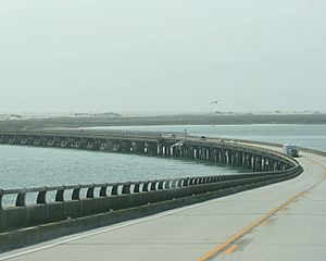
In November 1963, the Herbert C. Bonner Bridge was finished. This bridge connected Hatteras Island to the northern Outer Banks. The bridge was named after Herbert Covington Bonner, a congressman who helped the area. The money to build the bridge came from North Carolina, the U.S. Commerce Department, and the National Park Service.
If you're coming from the south, you can reach Hatteras by taking a 40-minute ferry ride from Ocracoke Island. There isn't a direct road connecting Hatteras Island to the mainland of Hyde County. This means a long drive around the Pamlico Sound if you don't take the ferry.
The Bonner Bridge faced challenges over the years. In October 1990, a fishing dredge broke loose during a storm and damaged part of the bridge. This cut off Hatteras Island's only road to the north. The bridge was fixed by February 1991.
In 2011, Hurricane Irene also damaged part of Highway 12. This road connects Nags Head to Rodanthe. Until a temporary bridge was built in October 2011, ferries were the only way to get to Hatteras Island.
In March 2016, work began on a new bridge to replace the Bonner Bridge. This new bridge, named after Senator Marc Basnight, opened in February 2019.
Learning on the Island: Education
Children living on Hatteras Island attend schools managed by Dare County Schools. The local schools are Cape Hatteras Elementary School and Cape Hatteras Secondary School.
 | DeHart Hubbard |
 | Wilma Rudolph |
 | Jesse Owens |
 | Jackie Joyner-Kersee |
 | Major Taylor |


