
Hatteras, North Carolina facts for kids
Quick facts for kids
Hatteras
|
|
|---|---|

Location in Dare County and the state of North Carolina
|
|
| Country | United States of America |
| State | North Carolina |
| County | Dare |
| Named for | Hatteras Indians |
| Area | |
| • Total | 2.47 sq mi (6.40 km2) |
| • Land | 1.58 sq mi (4.08 km2) |
| • Water | 0.89 sq mi (2.31 km2) |
| Elevation | 3 ft (0.9 m) |
| Population
(2020)
|
|
| • Total | 577 |
| • Density | 365.88/sq mi (141.27/km2) |
| ZIP code |
27943
|
| FIPS code | 37-30100 |
Hatteras is a small village located in Dare County, North Carolina, in the United States of America. It's found on the Outer Banks, a chain of islands along the coast. Hatteras is at the very southwestern tip of Hatteras Island.
In 2020, about 577 people lived here. Just west of Hatteras village is Hatteras Inlet. This is a narrow waterway that separates Hatteras Island from Ocracoke Island. North Carolina Highway 12 runs through Hatteras. It connects the village to Frisco to the east. To the west, you can take a ferry across Hatteras Inlet to Ocracoke.
The people of Hatteras are part of Dare County. They are represented by the Dare County Board of Commissioners. Hatteras is in District 4, along with several other nearby villages.
Contents
What is the Population of Hatteras?
Hatteras is a small community. In 2020, the census counted 577 people living there. Most residents are White. A small number of people are from other racial or ethnic backgrounds.
What Fun Things Can You Do in Hatteras?
Hatteras is a popular spot for outdoor activities. It's especially known for fishing and kiteboarding.
Watersports and Beaches
You can enjoy many watersports in Hatteras. The village has access to both the ocean side and the sound side. The Atlantic Ocean offers great waves for surfing. This is because two ocean currents, the Labrador Current and the Gulf Stream, meet nearby.
On the calmer Pamlico Sound side, you can try windsurfing, kayaking, and kiteboarding. Swimming is also a favorite activity here.
Fishing in Hatteras
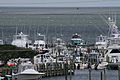
Fishing is a very important activity in Hatteras. It's both a hobby and a way for people to earn money. Hatteras has two large fishing fleets. These boats operate out of Hatteras Harbor Marina and Teach's Lair Marina.
Pamlico Sound is one of the biggest estuaries in the world. An estuary is where fresh river water mixes with salty ocean water. This unique environment provides many different fishing opportunities.
Graveyard of the Atlantic Museum
Hatteras is also home to the Graveyard of the Atlantic Museum. This museum tells the story of the area's rich maritime history. It also focuses on the thousands of shipwrecks that have happened off the coast. This part of the ocean is known as the Graveyard of the Atlantic.
What is the Climate Like in Hatteras?
Hatteras has a humid subtropical climate. This means it has hot summers. The Atlantic Ocean helps to keep the summer temperatures from getting too extreme. Winters in Hatteras are quite mild. The average low temperature never drops below 40 degrees Fahrenheit (4 degrees Celsius).
Hatteras is located far off the mainland. It is directly in the path of the Gulf Stream. This ocean current brings warm water. Because of this, Hatteras has mild low temperatures all year round. These temperatures are similar to places much further south, like northern Florida.
| Climate data for Hatteras, North Carolina (1981–2010 normals), | |||||||||||||
|---|---|---|---|---|---|---|---|---|---|---|---|---|---|
| Month | Jan | Feb | Mar | Apr | May | Jun | Jul | Aug | Sep | Oct | Nov | Dec | Year |
| Mean daily maximum °F (°C) | 54.4 (12.4) |
55.5 (13.1) |
60.5 (15.8) |
67.9 (19.9) |
75.3 (24.1) |
81.9 (27.7) |
85.7 (29.8) |
85.7 (29.8) |
82 (28) |
73.5 (23.1) |
65.4 (18.6) |
58 (14) |
70.5 (21.4) |
| Mean daily minimum °F (°C) | 40.6 (4.8) |
42.8 (6.0) |
47.4 (8.6) |
55.4 (13.0) |
63.5 (17.5) |
71.1 (21.7) |
75.1 (23.9) |
74.8 (23.8) |
71.2 (21.8) |
62.5 (16.9) |
53.5 (11.9) |
45.9 (7.7) |
58.7 (14.8) |
| Source: NOAA (North Carolina Observed Climate Normals) | |||||||||||||
A Brief History of Hatteras
Hatteras was named after the Hatteras Indians. They were a Native American group who lived in the area.
In 2003, Hurricane Isabel caused a big change to Hatteras Village. The storm created a new channel, about 3,000 feet wide and 30 feet deep. This channel, called Isabel Inlet, cut off the village from the rest of the island. The United States Army Corps of Engineers later repaired the land using sand.
Two important historical buildings in Hatteras are listed on the National Register of Historic Places. These are the Ellsworth and Lovie Ballance House and the Hatteras Weather Bureau Station.
How Do People Travel in Hatteras?
Hatteras has its own small airport, called Billy Mitchell Airport.
The village is also home to the Hatteras-Ocracoke Ferry terminal. This ferry is the main way for people to get to Ocracoke Island from Hatteras Village. The only other way is by air travel.
What About Schools in Hatteras?
Children living in Hatteras attend schools run by Dare County Schools. The local schools are Cape Hatteras Elementary School and Cape Hatteras Secondary School. Both schools are located in nearby Buxton, on NC 12.
The Dare County Library also has a branch located in Hatteras.
Images for kids
-
View of Pamlico Sound, near Hatteras Inlet from a home in Hatteras on a windy day in June 2007
-
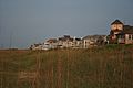
View of homes along oceanfront in Hatteras in June 2007
-

Busy Hatteras Ferry Lines on a Wednesday in June 2007
-
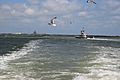
Ferries making trip from Ocracoke to Hatteras, June 2007
-
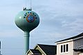
Water tower
-
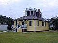
Historical US Weather Bureau office


See also
 In Spanish: Hatteras (Carolina del Norte) para niños
