
Frisco, North Carolina facts for kids
Quick facts for kids
Frisco, North Carolina
|
|
|---|---|

Frisco Native American Museum
|
|

Location in Dare County and the state of North Carolina
|
|
| Country | United States of America |
| State | North Carolina |
| County | Dare |
| Founded | 1898 |
| Named for | San Francisco, CA |
| Area | |
| • Total | 6.26 sq mi (16.20 km2) |
| • Land | 4.84 sq mi (12.54 km2) |
| • Water | 1.41 sq mi (3.66 km2) |
| Elevation | 3 ft (0.9 m) |
| Population
(2020)
|
|
| • Total | 994 |
| • Density | 205.24/sq mi (79.25/km2) |
| ZIP code |
27936
|
| FIPS code | 37-25020 |
Frisco is a small community located on Hatteras Island in North Carolina, United States. It's a "census-designated place" (CDP), which means it's an area identified by the government for statistics, but it doesn't have its own local government like a city or town.
Frisco is found between the villages of Buxton and Hatteras. It's part of Dare County. The community was first called "Trent" or "Trent Woods." It got its current name, Frisco, when a post office opened there in 1898.
Many homes in Frisco are rented out during the summer, so the number of people living there changes a lot throughout the year. In 2020, about 994 people lived there. North Carolina Highway 12 is the main road that connects Frisco to other places on the island.
The Billy Mitchell Airport is located in Frisco. It's named after a famous Army General, Billy Mitchell. Right across from this small airport, you can find the Frisco Native American Museum.
The people of Frisco are governed by the Dare County Board of Commissioners. Frisco is part of District 4, along with other nearby communities like Avon, Buxton, and Hatteras.
Contents
People in Frisco
A "census" is like a big count of all the people living in an area. It helps us understand how many people live somewhere and what groups they belong to.
Frisco's Population in 2020
In 2020, the United States census counted 994 people living in Frisco. There were 76 households and 28 families.
Here's a quick look at the different groups of people living in Frisco in 2020:
| Group | Number | Percentage |
|---|---|---|
| White (not Hispanic) | 924 | 92.96% |
| Black or African American (not Hispanic) | 2 | 0.2% |
| Native American | 5 | 0.5% |
| Asian | 4 | 0.4% |
| Pacific Islander | 1 | 0.1% |
| Other/Mixed | 18 | 1.81% |
| Hispanic or Latino | 40 | 4.02% |
Things to See and Do
Frisco has some interesting places to visit:
- Billy Mitchell Airport: A small local airport.
- Cape Hatteras National Seashore: A beautiful protected area along the coast.
- Frisco Native American Museum: A museum where you can learn about Native American history and culture.
- Frisco Pier: This pier was unfortunately destroyed by Hurricane Earl in 2010.
-
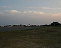
Billy Mitchell Airport in June 2007.
-
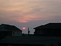
A beautiful sunset over Frisco in June 2008.
-
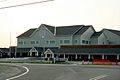
Construction of the new Cape Hatteras Elementary and Secondary School in June 2007.


Frisco's Weather
Frisco has a humid subtropical climate. This means it has hot and humid summers, cool winters, and it rains throughout the year.
During summer, a cool sea breeze often blows in the afternoons. However, it can get very hot and humid, sometimes feeling like 100°F (38°C) or more. Frisco is in an area where hurricanes can happen, especially from June to November.
In winter, it can get cold and windy. The average snowfall is very small, usually less than 2 inches (5 cm) per year.
| Climate data for Frisco, North Carolina (1991–2020 normals) | |||||||||||||
|---|---|---|---|---|---|---|---|---|---|---|---|---|---|
| Month | Jan | Feb | Mar | Apr | May | Jun | Jul | Aug | Sep | Oct | Nov | Dec | Year |
| Mean daily maximum °F (°C) | 53.9 (12.2) |
57.1 (13.9) |
61.8 (16.6) |
69.3 (20.7) |
76.9 (24.9) |
83.8 (28.8) |
86.7 (30.4) |
86.7 (30.4) |
82.2 (27.9) |
73.8 (23.2) |
65.0 (18.3) |
57.6 (14.2) |
71.2 (21.8) |
| Daily mean °F (°C) | 46.9 (8.3) |
48.9 (9.4) |
53.9 (12.2) |
61.9 (16.6) |
70.0 (21.1) |
77.5 (25.3) |
80.7 (27.1) |
80.5 (26.9) |
76.4 (24.7) |
67.3 (19.6) |
58.3 (14.6) |
51.2 (10.7) |
64.5 (18.1) |
| Mean daily minimum °F (°C) | 39.9 (4.4) |
40.7 (4.8) |
46.0 (7.8) |
54.5 (12.5) |
63.1 (17.3) |
71.1 (21.7) |
74.7 (23.7) |
74.2 (23.4) |
70.6 (21.4) |
60.8 (16.0) |
51.5 (10.8) |
44.7 (7.1) |
57.6 (14.2) |
| Average precipitation inches (mm) | 4.65 (118) |
4.30 (109) |
4.17 (106) |
3.95 (100) |
4.48 (114) |
4.82 (122) |
5.57 (141) |
7.03 (179) |
8.10 (206) |
5.23 (133) |
4.70 (119) |
4.56 (116) |
61.56 (1,564) |
| Source: NOAA | |||||||||||||
Plants and Nature
The natural plant life in Frisco is mainly made up of Live oak trees and Sea Oats (a type of grass). These plants are common in coastal areas.
Schools in Frisco
Students in Frisco attend schools that are part of Dare County Schools. The local schools are Cape Hatteras Elementary School and Cape Hatteras Secondary School.
See also
 In Spanish: Frisco (Carolina del Norte) para niños
