Perquimans County, North Carolina facts for kids
Quick facts for kids
Perquimans County
|
|||
|---|---|---|---|

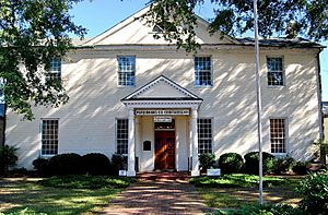
Perquimans County Courthouse
|
|||
|
|||

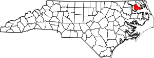
Location within the U.S. state of North Carolina
|
|||
 North Carolina's location within the U.S. |
|||
| Country | |||
| State | |||
| Founded | 1668 | ||
| Named for | Yeopim word meaning “The land of beautiful women” | ||
| Seat | Hertford | ||
| Largest community | Hertford | ||
| Area | |||
| • Total | 328.93 sq mi (851.9 km2) | ||
| • Land | 247.17 sq mi (640.2 km2) | ||
| • Water | 81.76 sq mi (211.8 km2) 24.86% | ||
| Population
(2020)
|
|||
| • Total | 13,005 | ||
| • Estimate
(2023)
|
13,377 | ||
| • Density | 52.62/sq mi (20.32/km2) | ||
| Time zone | UTC−5 (Eastern) | ||
| • Summer (DST) | UTC−4 (EDT) | ||
| Congressional district | 1st | ||
Perquimans County is a county in North Carolina, a state in the United States. It's pronounced "pur-KWIM-unz." In 2020, about 13,005 people lived here. The main town and county seat is Hertford. A special facility called the Harvey Point Defense Testing Activity is also found in Perquimans County.
Contents
Discovering Perquimans County's Past
Perquimans County has a long history. It was first created in 1668 as Berkeley Precinct. Around 1684, its name changed to Perquimans Precinct. It officially became a county in 1739. The largest town and the county seat is Hertford.
Exploring Perquimans County's Geography
Perquimans County covers a total area of about 329 square miles. Most of this area, about 247 square miles, is land. The rest, about 82 square miles, is water. This means water makes up almost 25% of the county's total area.
Major Waterways in the County
- Albemarle Sound
- Little River
- Perquimans River
Neighboring Counties
Perquimans County shares borders with several other counties:
- Gates County to the northwest
- Pasquotank County to the east
- Tyrrell County to the south
- Washington County to the south
- Chowan County to the southwest
Main Roads and Highways
These are the major roads that run through Perquimans County:

 Future I-87
 US 17
US 17
 US 17 Bus.
 NC 37
NC 37
Population and People of Perquimans County
The population of Perquimans County has changed over many years. The U.S. Decennial Census counts the number of people living in the county every ten years. In 1790, there were about 5,439 people. By 2020, the population had grown to 13,005.
| Historical population | |||
|---|---|---|---|
| Census | Pop. | %± | |
| 1790 | 5,439 | — | |
| 1800 | 5,708 | 4.9% | |
| 1810 | 6,052 | 6.0% | |
| 1820 | 6,857 | 13.3% | |
| 1830 | 7,419 | 8.2% | |
| 1840 | 7,346 | −1.0% | |
| 1850 | 7,332 | −0.2% | |
| 1860 | 7,238 | −1.3% | |
| 1870 | 7,945 | 9.8% | |
| 1880 | 9,466 | 19.1% | |
| 1890 | 9,293 | −1.8% | |
| 1900 | 10,091 | 8.6% | |
| 1910 | 11,054 | 9.5% | |
| 1920 | 11,137 | 0.8% | |
| 1930 | 10,668 | −4.2% | |
| 1940 | 9,773 | −8.4% | |
| 1950 | 9,602 | −1.7% | |
| 1960 | 9,178 | −4.4% | |
| 1970 | 8,351 | −9.0% | |
| 1980 | 9,486 | 13.6% | |
| 1990 | 10,447 | 10.1% | |
| 2000 | 11,368 | 8.8% | |
| 2010 | 13,453 | 18.3% | |
| 2020 | 13,005 | −3.3% | |
| 2023 (est.) | 13,377 | −0.6% | |
| U.S. Decennial Census 1790–1960 1900–1990 1990–2000 2010 2020 |
|||
Who Lives in Perquimans County? (2020 Census)
The 2020 census showed that Perquimans County is home to a diverse group of people.
| Race | Number | Percentage |
|---|---|---|
| White (non-Hispanic) | 9,333 | 71.76% |
| Black or African American (non-Hispanic) | 2,686 | 20.65% |
| Native American | 35 | 0.27% |
| Asian | 36 | 0.28% |
| Pacific Islander | 7 | 0.05% |
| Other/Mixed | 599 | 4.61% |
| Hispanic or Latino | 309 | 2.38% |
In 2020, there were 13,005 people living in the county. These people lived in 5,936 households, which included 4,023 families.
Education in Perquimans County
Schools in Perquimans County are part of the Perquimans County Schools system. This system provides education for students living in the county.
Communities and Towns
Towns in Perquimans County
Unincorporated Communities
These are smaller communities that are not officially towns:
Townships
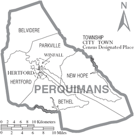
Townships are smaller divisions within the county:
- Belvidere
- Bethel
- Hertford
- New Hope
- Parkville
Famous People from Perquimans County
Some well-known individuals have connections to Perquimans County:
- Janice Cole, who served as a U.S. Attorney.
- Catfish Hunter, a famous professional baseball pitcher who played for the Kansas City/Oakland A's and New York Yankees.
- Wolfman Jack, a popular radio personality.
See also
 In Spanish: Condado de Perquimans para niños
 | Stephanie Wilson |
 | Charles Bolden |
 | Ronald McNair |
 | Frederick D. Gregory |


